Data Snapshots: Reusable Climate Maps


Explore a range of easy-to-understand climate maps in a single interface. Featuring the work of NOAA scientists, each “snapshot” is a public-friendly version of an existing data product.
Dataset Spotlight: U.S. Climatological Rankings - Ranking Chart
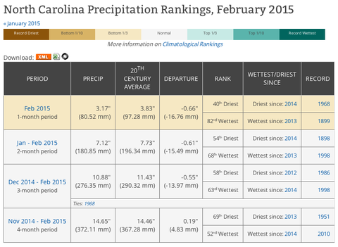
When you hear or see news that a region had its hottest or wettest month since records began, you can check the climatological record books yourself. Use this page to see how conditions in U.S. Climate Divisions, states, or regions over a month or longer period rank among the historical record.
Where did these data come from?
See Climate Trends in Your State

View graphs of historical average temperature for any of the 48 contiguous United States.
![]()