Map
New map of Texas : with the contiguous American & Mexican states /

| Format |
Map |
|---|---|
| Contributors |
Young, J. H. |
| Dates |
1835 |
| Location |
Texas United States |
| Language |
English |
| Subjects |
19Th Century Land Grants Texas United States |
- Title
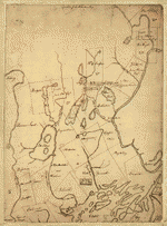
- New map of Texas : with the contiguous American & Mexican states /
- Description
-
Shows colonies and land grants, Neuces River as border between Texas and Mexican states, Indian Territory attached to Arkansas, Santa Fe area, towns, rivers, and roads.
-
Title from title block.
-
"Engraved by J. H. Young."
-
Relief shown by hachures.
-
Additional longitudinal coordinates measured west from Washington (W 29°00'--W 11°15').
-
"Sold by Mitchell & Hinman."
-
"Entered according to act of Congress in the year 1835 by S. Augustus Mitchell in the clerk's office of the district court of the eastern district of Pennsylvania."
-
Available also through the Library of Congress Web site as a raster image.
-
Includes text: "Rivers of Texas," "Land Grants," and "Remarks on Texas."
-
Has ornamental border.
-
1 map : hand col. ; 30 x 36 cm.
- Creator
- Young, J. H.
- Created Published
-
Philadelphia : S. Augustus Mitchell, 1835.
- Subject Headings
-
-
Texas--19th century
-
-
Land grants--Texas--19th century
-
-
United States--Texas.
- Notes
-
-
Shows colonies and land grants, Neuces River as border between Texas and Mexican states, Indian Territory attached to Arkansas, Santa Fe area, towns, rivers, and roads.
-
-
Title from title block.
-
-
"Engraved by J. H. Young."
-
-
Relief shown by hachures.
-
-
Additional longitudinal coordinates measured west from Washington (W 29°00'--W 11°15').
-
-
"Sold by Mitchell & Hinman."
-
-
"Entered according to act of Congress in the year 1835 by S. Augustus Mitchell in the clerk's office of the district court of the eastern district of Pennsylvania."
-
-
Available also through the Library of Congress Web site as a raster image.
-
-
Includes text: "Rivers of Texas," "Land Grants," and "Remarks on Texas."
-
-
Has ornamental border.
- Medium
-
1 map : hand col. ; 30 x 36 cm.
- Call Number
-
G4030 1835 .Y6
- Repository
-
Library of Congress Geography and Map Division Washington, D.C. 20540-4650 USA dcu
- Digital Id
-
g4030 ct002350 http://hdl.loc.gov/loc.gmd/g4030.ct002350
- Library of Congress Catalog Number
- 2008625106
Rights & Access
The maps in the Map Collections materials were either published prior to 1922, produced by the United States government, or both (see catalogue records that accompany each map for information regarding date of publication and source). The Library of Congress is providing access to these materials for educational and research purposes and is not aware of any U.S. copyright protection (see Title 17 of the United States Code) or any other restrictions in the Map Collection materials.
Note that the written permission of the copyright owners and/or other rights holders (such as publicity and/or privacy rights) is required for distribution, reproduction, or other use of protected items beyond that allowed by fair use or other statutory exemptions. Responsibility for making an independent legal assessment of an item and securing any necessary permissions ultimately rests with persons desiring to use the item.
More about Copyright and other Restrictions
For guidance about compiling full citations consult Citing Primary Sources.
Part of...
-
General Maps
[2477]
-
Geography And Maps Division
[60803]
-
American Memory
[1121009]
More maps like this
-
 Map of Massachusetts, Connecticut and Rhode Island; constructed from the latest authorities.
Contributor:
Young, J. H.
Site:
American Memory-cultural, Main Catalog
Original Format:
Map
Date:
1831
View catalog record
Map of Massachusetts, Connecticut and Rhode Island; constructed from the latest authorities.
Contributor:
Young, J. H.
Site:
American Memory-cultural, Main Catalog
Original Format:
Map
Date:
1831
View catalog record
-
 Brazil, Bolivia & Peru.
Contributor:
Young, J. H.
Site:
American Memory-cultural, Main Catalog
Original Format:
Map
Date:
1829
View catalog record
Brazil, Bolivia & Peru.
Contributor:
Young, J. H.
Site:
American Memory-cultural, Main Catalog
Original Format:
Map
Date:
1829
View catalog record
-
 A map of the Federal Territory from the western boundary of Pennsylvania to the Scioto River
Contributor:
Cutler, Manasseh
Site:
American Memory-cultural, Main Catalog
Original Format:
Map
Date:
1785
View catalog record
A map of the Federal Territory from the western boundary of Pennsylvania to the Scioto River
Contributor:
Cutler, Manasseh
Site:
American Memory-cultural, Main Catalog
Original Format:
Map
Date:
1785
View catalog record
-
 A Portion of New York from the Hudson River west to the Unadilla Branch of the Susquehanna River; from the Delaware River north to Fort ...
Site:
American Memory-cultural, Main Catalog
Original Format:
Map
Date:
1700
View catalog record
A Portion of New York from the Hudson River west to the Unadilla Branch of the Susquehanna River; from the Delaware River north to Fort ...
Site:
American Memory-cultural, Main Catalog
Original Format:
Map
Date:
1700
View catalog record
-
 Map of the patent of Oriskany.
Site:
American Memory-cultural, Main Catalog
Original Format:
Map
Date:
1785
View catalog record
Map of the patent of Oriskany.
Site:
American Memory-cultural, Main Catalog
Original Format:
Map
Date:
1785
View catalog record
-
 A plan of the township of Blenheim, as surveyed and divided in the year 1772.
Contributor:
Creassy, James
Site:
American Memory-cultural, Main Catalog
Original Format:
Map
Date:
1772
View catalog record
A plan of the township of Blenheim, as surveyed and divided in the year 1772.
Contributor:
Creassy, James
Site:
American Memory-cultural, Main Catalog
Original Format:
Map
Date:
1772
View catalog record
-
 [Plat of a survey of 2,314 acres of land, being the first large bottom on the east side of the Ohio River, 3 or 4 ...
Contributor:
Crawford, William
Site:
American Memory-cultural, Main Catalog
Original Format:
Map
Date:
1771
View catalog record
[Plat of a survey of 2,314 acres of land, being the first large bottom on the east side of the Ohio River, 3 or 4 ...
Contributor:
Crawford, William
Site:
American Memory-cultural, Main Catalog
Original Format:
Map
Date:
1771
View catalog record
-
 [Eight survey tracts along the Kanawha River, W.Va. showing land granted to George Washington and others.
Contributor:
Washington, George
Site:
American Memory-cultural, Main Catalog
Original Format:
Map
Date:
1774
View catalog record
[Eight survey tracts along the Kanawha River, W.Va. showing land granted to George Washington and others.
Contributor:
Washington, George
Site:
American Memory-cultural, Main Catalog
Original Format:
Map
Date:
1774
View catalog record
-
 A plan of part of the rivers Tombecbe, Alabama, Tensa, Perdido, & Scambia in the province of West Florida; with a sketch of the boundary ...
Contributor:
Taitt, David
Site:
American Memory-cultural, Main Catalog
Original Format:
Map
Date:
1771
View catalog record
A plan of part of the rivers Tombecbe, Alabama, Tensa, Perdido, & Scambia in the province of West Florida; with a sketch of the boundary ...
Contributor:
Taitt, David
Site:
American Memory-cultural, Main Catalog
Original Format:
Map
Date:
1771
View catalog record
-
 [Thomas Hutchins' land grant and map to 2000 acres in West Florida] /
Contributor:
Durnford, Elias Walker
Site:
American Memory-cultural, Main Catalog
Original Format:
Map
Date:
1776
View catalog record
[Thomas Hutchins' land grant and map to 2000 acres in West Florida] /
Contributor:
Durnford, Elias Walker
Site:
American Memory-cultural, Main Catalog
Original Format:
Map
Date:
1776
View catalog record
-
 The above plan is a discription of a new township called Royalsborough in the county of Cumberland, bounded southeasterly on the headline of Brunswick, southwesterly ...
Contributor:
Noyes, Joseph
Site:
American Memory-cultural, Main Catalog
Original Format:
Map
Date:
1766
View catalog record
The above plan is a discription of a new township called Royalsborough in the county of Cumberland, bounded southeasterly on the headline of Brunswick, southwesterly ...
Contributor:
Noyes, Joseph
Site:
American Memory-cultural, Main Catalog
Original Format:
Map
Date:
1766
View catalog record
-
 Copy of a survey return'd by Mr. Sam Lewis, surveyor of Botetourt Coun[t]y. Surveyed for George Washington 2950 acres of land (by virtue of a ...
Contributor:
Lewis, Samuel
Site:
American Memory-cultural, Main Catalog
Original Format:
Map
Date:
1774
View catalog record
Copy of a survey return'd by Mr. Sam Lewis, surveyor of Botetourt Coun[t]y. Surveyed for George Washington 2950 acres of land (by virtue of a ...
Contributor:
Lewis, Samuel
Site:
American Memory-cultural, Main Catalog
Original Format:
Map
Date:
1774
View catalog record
-
 Part of Oxford and Cumberland counties, Me.
Contributor:
Greenleaf, S.
Site:
American Memory-cultural, Main Catalog
Original Format:
Map
Date:
1771
View catalog record
Part of Oxford and Cumberland counties, Me.
Contributor:
Greenleaf, S.
Site:
American Memory-cultural, Main Catalog
Original Format:
Map
Date:
1771
View catalog record
-
 [Map of Las Ormigas Grant, Sabine and DeSoto Parishes, Louisiana].
Site:
American Memory-cultural, Main Catalog
Original Format:
Map
View catalog record
[Map of Las Ormigas Grant, Sabine and DeSoto Parishes, Louisiana].
Site:
American Memory-cultural, Main Catalog
Original Format:
Map
View catalog record
-
 A map of Wayne & Pike counties, Pennsylvania : showing the situations & forms of the warrantee tracts, with the numbers by which the respective ...
Contributor:
Torrey, Jason
Site:
American Memory-cultural, Main Catalog
Original Format:
Map
Date:
1814
View catalog record
A map of Wayne & Pike counties, Pennsylvania : showing the situations & forms of the warrantee tracts, with the numbers by which the respective ...
Contributor:
Torrey, Jason
Site:
American Memory-cultural, Main Catalog
Original Format:
Map
Date:
1814
View catalog record
-
 View of the city of Washington in 1792.
Site:
American Memory-cultural, Main Catalog
Original Format:
Map
Date:
1860
View catalog record
View of the city of Washington in 1792.
Site:
American Memory-cultural, Main Catalog
Original Format:
Map
Date:
1860
View catalog record
You might also like
-

 A journey through Texas; or, A saddle-trip on the south-western frontier: with a statistical appendix.
Contributor:
Olmsted, Frederick Law
Site:
Main Catalog
Original Format:
Book
Date:
1859
A journey through Texas; or, A saddle-trip on the south-western frontier: with a statistical appendix.
Contributor:
Olmsted, Frederick Law
Site:
Main Catalog
Original Format:
Book
Date:
1859
-
 Flax, a new crop for south Texas, harvested with FSA (Farm Security Administration)-financed equipment
Site:
Prints & Photographs
Original Format:
Photo, Print, Drawing
Date:
1939
Flax, a new crop for south Texas, harvested with FSA (Farm Security Administration)-financed equipment
Site:
Prints & Photographs
Original Format:
Photo, Print, Drawing
Date:
1939
-
Farms for soldiers : letters from the Secretary of the Interior, House of Resprestatives, Sixty-sixth Congress, first session transmitting reports from Army officals showing the ...
Contributor:
United States. Congress. House. Committee on Public Lands
Site:
Main Catalog
Original Format:
Book
Date:
1919-08-01
-
Lands for educational purposes ...
Contributor:
United States. Congress. House. Committee on the Public Lands
Site:
Main Catalog
Original Format:
Book
Date:
1916
-
Following the drum,
Contributor:
Vielé, Teresa Griffin
Site:
Main Catalog
Original Format:
Book
Date:
1864
-
 Waiting in line for a bus
Contributor:
O'Rourke, Phil
Site:
American Memory-cultural
Original Format:
Photo, Print, Drawing
Date:
1944
Waiting in line for a bus
Contributor:
O'Rourke, Phil
Site:
American Memory-cultural
Original Format:
Photo, Print, Drawing
Date:
1944