
- 12201 Sunrise Valley Drive
- Reston, VA 20192, USA
- 703-648-5953
- 1-888-ASK-USGS
- Employee Directory
- Web Chat
We conduct impartial, multi- and interdisciplinary research and monitoring to address a broad range of natural-resource issues that affect the quality of life of citizens and landscapes in the Southeastern United States and the Caribbean region.

Get real-time and historical surface-water, groundwater, and water-quality conditions and data for states in the Southeast region. Our data is accessible via forms and lists or from a map-based system.
Get water data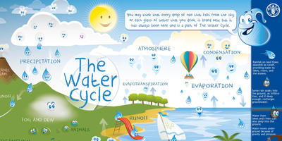
The USGS has created a water-cycle diagram for schools and "kids" ages 5-95. The diagram is available in over 20 languages. An interactive diagram is available to let you "mouse around" the parts water cycle and view explanations and see pictures.
Start learning!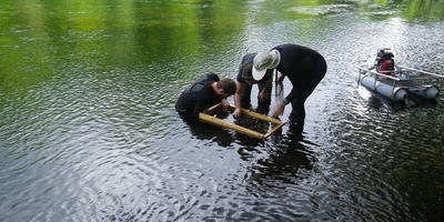
The Wetland and Aquatic Research Center (WARC) provides science with impact to ensure that its research is relevant and useful for resource managers, policy makers, and the public.
Visit the site
A regional assessment of untreated groundwater in the Coastal Lowlands aquifer system in the southeastern United States is now available from the U.S. Geological Survey.
A regional assessment of untreated groundwater in the Southeastern Coastal Plain aquifer system is now available from the U.S. Geological Survey.
A regional assessment of untreated groundwater in the combined Valley and Ridge and Piedmont and Blue Ridge aquifers in the eastern United States is now available from the U.S. Geological Survey.
Mangrove forests are highly productive tidal saline wetland ecosystems found along sheltered tropical and subtropical coasts. Ecologists have long assumed that climatic drivers (i.e., temperature and rainfall regimes) govern the global distribution, structure, and function of mangrove forests. However, data constraints have hindered the...
The US Endangered Species Act of 1973 (ESA) affords many potential benefits to species threatened with extinction. However, most at-risk amphibians—one of the most imperiled vertebrate groups—remain unlisted under the provisions of the ESA, and many impediments to recovery exist for those species that have been listed. Of the 35 US amphibian...
The pervasive influence of human induced global environmental change affects biodiversity across the globe, and there is great uncertainty as to how the biosphere will react on short and longer time scales. To adapt to what the future holds and to manage the impacts of global change, scientists need to predict the expected effects with some...
We conduct impartial, multi- and interdisciplinary research and monitoring on a large range of natural-resource issues that impact the quality of life of citizens and landscapes of the Southeastern United States and the Caribbean region.
LMG-WSC hydrologist, in collaboration with Arkansas Natural Resource Commission scientist are analyzing stream channel geomorphic characteristics at 15 gaged stable stream sites in the Boston Mountains of Arkansas. Field data collection entails topographic surveys of selected stream reaches and analysis of bed and bar sediments. Topographic surveys, running from hundreds to thousands of feet,...
The Mississippi Alluvial Plain is one of the most productive agricultural regions in the Nation and depends on groundwater for irrigation. The MAP area constitutes the third largest area of irrigated cropland in the United States. The area is approximately 29,000 square miles (19 million acres) and includes parts of the States...
The Challange: The DOI WaterSMART (Sustain and Manage America’s Resources for Tomorrow) initiative is developing data and tools to help water managers identify current and future water shortages, for humans and for freshwater ecosystems. Fishes, for example, can decline in diversity and abundance when streamflow becomes too low, for too long. However, ecologists find that effects...
Invasive species are considered to be second only to habitat degradation in terms of negative impacts on the Earth’s ecosystems, and our scientists make up a significant proportion of the global expertise in the rapidly-growing problem of invasive reptiles....
The Daniel Beard Center in Everglades National Park provides the base for most of the field work done on the control of invasive reptiles by USGS Fort Collins Science Center staff. The team works in Everglades National Park, Big Cypress National Preserve, Crocodile Lake National Wildlife Refuge, and other parts of the Greater Everglades Ecosystem focusing on, among other species of concern,...
Groundwater resources in northwestern Louisiana may be needed for development of natural gas production from the Haynesville Shale. Use of groundwater for hydro-fracturing of the shale may lower water levels and alter groundwater flow directions in the Carrizo-Wilcox aquifer and other local aquifers. Regional maps of aquifers in northwestern Louisiana are unavailable. The LaWSC, in cooperation...
Hurricanes bring destructive winds, storm surge, torrential rain, flooding, and tornadoes. A single storm can wreak havoc on coastal and inland communities and on natural areas over thousands of square miles. In 2005, Hurricanes Katrina, Rita, and Wilma demonstrated the devastation that hurricanes can inflict and the importance of hurricane hazards research and preparedness.
More...
Metro Nashville Flood Monitoring Project-This project monitors the Cumberland River and it's tributaries around the Nashville Metro Area. You can learn more at: http://tn.water.usgs.gov/projects/metronashville/index.html...
Maculata applesnails (Pomacea maculata) are exotic freshwater snails that have been widely introduced along the Gulf of Mexico coast. The snails can significantly impact freshwater macrophytes and reduce the quality of water bodies.
Nutrias (Myocastor coypus) are an aquatic rodent imported from South America to the United States in the 1920-40’s for the fur farms. Since their original importation they have become established in the wild in many regions of the United States....
Maculata applesnails (Pomacea maculata) are exotic freshwater snails that have been widely introduced along the Gulf of Mexico coast. They can significantly impact freshwater macrophytes and reduce water quality.
The Molecular Ecology Laboratory applies genetic and genomic technologies to address a variety of complex questions and conservation issues facing the management of the Nation's fish and wildlife resources. Together with our partners, we design and implement studies to document genetic diversity and the distribution of genetic variation among individuals, populations, and species....
We conduct impartial, multi- and interdisciplinary research and monitoring on a large range of natural-resource issues that impact the quality of life of citizens and landscapes of the Southeastern United States and the Caribbean region.
USGS National Water Data Portal
See Current Water Conditions for Tennessee using our new interactive map. Here you can find information on Groundwater, Surface Water and Water Quality.

See Current Water Conditions for Louisiana using our new interactive map. Here you can find information on Groundwater, Surface Water and Water Quality.

See Current Water Conditions for Mississippi using our new interactive map. Here you can find information on Groundwater, Surface Water and Water Quality.

See Current Water Conditions for Arkansas using our new interactive map. Here you can find information on Groundwater, Surface Water and Water Quality.

See Current Water Conditions for Alabama using our new interactive map. Here you can find information on Groundwater, Surface Water and Water Quality.

Information and products are organized within three coastal change hazard themes: 1) extreme storms, 2) shoreline change, and 3) sea-level rise. Each data item represents an individual research product, with some items grouped together as aggregates to show the breadth of the topic and make it easy to explore.

Map of below normal 7-day average streamflow compared to historical streamflow for the day of year (Tennessee)

Groundwater Watch is a supplemental tool to NWISWeb and, as such, is able to provide additional benefits to the groundwater community. NWIS is the authoritative database for USGS groundwater data, and NWISWeb is the public interface for these groundwater data. This is information pertaining to the Memphis Area Groundwater-Level Network.

The interactive sea-level rise visualization tool results from a collaborative effort between NOAA's Coastal Services Center, USGS WARC, and USGS Mississippi Water Science Center. The tool illustrates the scale of potential flooding, but not the exact location, and does not account for erosion, subsidence, sediment accretion, or future construction.

MsCIP was developed in 2009 by the U.S. Army Corps of Engineers, Mobile District, in conjunction with other Federal and State agencies, to help reduce future storm damage along the Mississippi Gulf coast. In 2014, in cooperation with the USACE Mobile District, WARC's Advanced Applications Team began development on the MsCIP Data Viewer, an interactive web-mapping environment.

The JEM community of practice is focused on ecological modeling and monitoring across the Greater Everglades, with particular interest in habitats, how various factors affect habitat change, and how the organisms dependent on those habitats respond today and into the future.

The 3DEP products and services available through The National Map consist of lidar point clouds (LPC), standard digital elevation models (DEMs) at various horizontal resolutions, elevation source and associated datasets, an elevation point query service and bulk point query service. All 3DEP products are available, free of charge and without use restrictions.

River and Coastal Forecast Information
Lower Mississippi River Forecast Center, Slidell, Louisiana—(NWS)
The 3DEP products and services available through The National Map consist of standard digital elevation models (DEMs) at various horizontal resolutions, elevation source and associated datasets, an elevation point query service and bulk point query service. All 3DEP products are available, free of charge and without use restrictions.

This portal is a “go to” source for maps related to ocean and coastal mapping. Information is organized by geography or region, by theme, and by the year data was published.

River and Coastal Forecast Information
Mississippi and Ohio River 7-Day Summary and Forecast

The Union County Water Conservation Board with funding from the U.S. Environmental Protection Agency began a study in 2003 with the U.S. Geological Survey, the Union County Conservation District, Burns & McDonnell to monitor the impact of water-level recovery and water-quality characteristics of the Sparta aquifer system in southern Arkansas and northern Louisiana.
The track of Hurricane Andrew carried it across one of the most extensive mangrove for ests in the New World.
Smith, Thomas J.; Robblee, Michael B.; Wanless, Harold R.; Doyle, Thomas W.No abstract available.
Kitchens, Wiley M.; Bennetts, Robert E.; DeAngelis, Donald L.
Cycling nutrient-enriched wastewater from holding ponds through natural, forested wetlands is a practice that municipal waste treatment managers are considering as a viable option for disposing of wastewater. In this wastewater cycling process, sewer effluent that has been circulated through aerated ponds is discharged into neighboring wetland...
Doyle, Thomas W.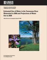
The Tennessee River system is the Nation’s fifth largest river system with a 40,910 mi2 drainage area. The Tennessee water-resources region (WRR), which corresponds to the Tennessee River watershed, ranked tenth among the 21 nationally designated WRRs in the United States in the volume of average daily withdrawals of freshwater in 1995. These...
Susan S. Hutson, M. Carolyn Koroa, and C. Michael Murphree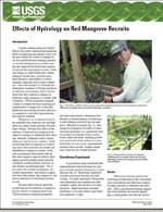
Coastal wetlands along the Gulf of Mexico have been experiencing significant shifts in hydrology and salinity levels over the past century as a result of changes in sea level and freshwater drainage patterns. Local land management in coastal zones has also impacted the hydrologic regimes of salt marshes and mangrove areas. Parks and refuges in...
Doyle, Thomas W.
This guide to the geology and biology of the Dry Tortugas is divided into four sections: 1) geologic and anthropogenic features you will pass on your trip to and from the Tortugas, 2) a summary of items of Tortugas geologic, historic, and human interest and what you will experience at Loggerhead Key while walking and snorkeling, 3) a summary of...
Shinn, Eugene A.; Jaap, Walter C.
Carbon dioxide (CO2) concentration in the atmosphere has steadily increased from 280 parts per million (ppm) in preindustrial times to 381 ppm today and is predicted by some models to double within the next century. Some of the important pathways whereby changes in atmospheric CO2 may impact coastal wetlands include changes in temperature,...
McKee, KarenWe provide information about the effects of Hurricane Katrina on populations of an invasive fish, the Nile tilapia (Oreochromis niloticus) in southern Mississippi. By resampling areas surveyed before the storm, we attempted to determine whether the species expanded its range by moving with storm-related floods. Additionally, we used rotenone to...
Schofield, Pamela J.; Slack, W. Todd; Peterson, Mark S.; Gregoire, Denise R.The Florida snail kite (Rostrhamus sociabilis) is an endangered raptor that occurs as an isolated population, currently of about 2,000 birds, in the wetlands of southern and central Florida, USA. Its exclusive prey species, the apple snail (Pomacea paludosa) is strongly influenced by seasonal changes in water abundance. Droughts during the snail...
Mooij, Wolf M.; Martin, Julien; Kitchens, Wiley M.; DeAngelis, Donald L.

A continuing assessment of water availability and demand is basic to the economic health and future of the State of Tennessee. Population growth in many parts of the State has resulted in increased competition for available water resources. This competition includes off-stream uses for domestic, agricultural, and industrial use as well as in-...
Susan S. Hutson
Water Well Constrution Reports entered online.


A regional assessment of untreated groundwater in the Coastal Lowlands aquifer system in the southeastern United States is now available from the U.S. Geological Survey.
A regional assessment of untreated groundwater in the Southeastern Coastal Plain aquifer system is now available from the U.S. Geological Survey.
A regional assessment of untreated groundwater in the combined Valley and Ridge and Piedmont and Blue Ridge aquifers in the eastern United States is now available from the U.S. Geological Survey.

Water users around the country can now view the past and simulated future of hydrologic processes.


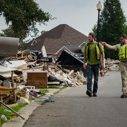
The heavy rains and storm surge Hurricane Matthew produced caused severe flooding in many parts of the south east, resulting in almost 40 peak flood records. As the flood waters continue to recede from some affected areas, the U. S. Geological Survey will continue its efforts to record this historic flooding. Click here to learn more about the work the USGS has completed for Hurricane Matthew.

Reporters: Want more information? Please contact Jeanne Robbins, jrobbins@usgs.gov, 919-571-4017

As the east coast prepares for Hurricane Matthew's arrival, the U.S. Geological Survey uses advanced models to forecast the coastal impacts Matthew could bring.

Burmese pythons have been found on Key Largo.

After the floodwaters recede, the search for the high-water marks begins

The USGS response to the Louisiana floods is part of the larger USGS flood science mission...

Wonder what Backwater Flooding is? We've got your answer here...

Phone: 352-378-8181
Fax: 352-378-4956

Phone: 337-266-8500
Fax: 337-266-8513

GS-W-TNnsh Webmaster@usgs.gov
Phone: (615) 837-4700
Fax: (615) 837-4799

Phone: (334) 395-4140
Fax: (334) 395-4168

Phone: (601) 933-2900
Fax: (601) 933-2901
Phone: (225) 298-5481
Fax: (225) 298-5490

Phone: (787) 749-7400

Phone: (919) 571-4000
Fax: (919) 571-4041

Phone: (803) 750-6100
Fax: (803) 750-6181

Phone: (678) 924-6700
Fax: (678) 924-6710

Phone: (813) 498-5000
Fax: (813) 498-5002

Phone: (727) 502-8000
Fax: (727) 502-8181

Phone: (703) 648-4230
Phone: (501) 228-3600

Phone: 901-678-7287
Fax: 901-678-7300
Phone: 865-862-2031

Phone: 205-348-0950
Phone: (318) 251-9630

Phone: (479) 442-4888


")
