


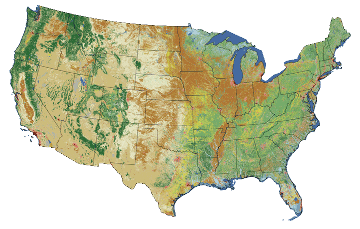
NLCD 2011
NLCD 2006
NLCD 2001
NLCD Shrubland
NLCD MODIS Albedo
Retrofit Land Cover Change
NLCD 1992
|
National Land Cover Database 2011 (NLCD 2011)
Preferred NLCD 2011 citation:
Homer, C.G., Dewitz, J.A., Yang, L., Jin, S., Danielson, P., Xian, G., Coulston, J., Herold, N.D., Wickham, J.D., and Megown, K., 2015, Completion of the 2011 National Land Cover Database for the conterminous United States-Representing a decade of land cover change information. Photogrammetric Engineering and Remote Sensing, v. 81, no. 5, p. 345-354
Preferred NLCD 2011 Percent Developed Imperviousness citation: Xian, G., Homer, C., Dewitz, J., Fry, J., Hossain, N., and Wickham, J., 2011. The change of impervious surface area between 2001 and 2006 in the conterminous United States. Photogrammetric Engineering and Remote Sensing, Vol. 77(8): 758-762. Related Publications for NLCD 2011 Coulston, J. W., Jacobs, D. M., King, C. R., and Elmore, I. C. 2013. The influence of multi-season imagery on models of canopy cover: a case study. Photogrammetric Engineering & Remote Sensing 79(5):469-477. Coulston, J. W., Moisen, G. G., Wilson, B. T., Finco, M. V., Cohen, W. B., and Brewer, C. K. 2012. Modeling percent tree canopy cover: a pilot study. Photogrammetric Engineering & Remote Sensing 78(7): 715-727. Jin, S., Yang, L., Danielson, P., Homer, C., Fry, J., and Xian, G. 2013. A comprehensive change detection method for updating the National Land Cover Database to circa 2011. Remote Sensing of Environment, 132: 159 � 175. Jin, S., Homer, C., Yang, L., Xian, G., Fry, J., Danielson, P., and Townsend, P. 2013. Automated cloud and shadow detection and filling using two-date Landsat imagery in the USA. International Journal of Remote Sensing, 34:5, 1540-1560. Johnson, D., and Mueller, R. 2010. The 2009 cropland data layer. Photogrammetric Engineering & Remote Sensing. 76(11):1201-1205. Tipton, J., Moisen, G., Patterson, P., Jackson, T. A., and Coulston, J. 2012. Sampling intensity and normalizations: Exploring cost-driving factors in nationwide mapping of tree canopy cover. In: McWilliams, W., and Roesch, F. A., eds. 2012. Monitoring Across Borders: 2010 Joint Meeting of the Forest Inventory and Analysis (FIA) Symposium and the Southern Mensurationists. e-Gen. Tech. Rep. SRS-157. Asheville, NC: US Department of Agriculture, Forest Service, Southern Research Station: 201-208. To view and print the PDF you must obtain and install the Acrobat® Reader, available at no charge from Adobe Systems. |
