HOME | ABOUT US | CONTACT | REGIONAL MANAGERS
 
  Nautical Charts & Pubs  
 
  Nautical Charts & Products  
     •   Print-on-Demand Charts (POD)  
     •   PDF Nautical Charts  
     •   Raster Navigational Charts: NOAA RNC®  
     •   Electronic Navigational Charts: NOAA ENC®  
     •   BookletChart™  
     •   Chart Updates (LNM and NM Corrections)  
 
  Nautical Charting Publications  
     •   United States Coast Pilot®  
     •   U.S. Chart No. 1  
     •   Chart Catalogs  
     •   Dates of Latest Editions (DOLE)  
     •   Upcoming New Editions  
 
  Nautical Charting Utilities  
     •   Chart Locator  
     •   NOAA ENC® Online  
 
  Historical Products  
     •   Historical Maps and Charts  
     •   Historical Coast Pilots  
 
  Learn About Charting Products  
     •   Last Correction and Cleared through Dates  
     •   Obtain Charting Products  
     •   How Publications are Updated  
     •   Differences Between Maps & Charts  
     •   Learn About Nautical Charts  
     •   DGPS & Your Chart  
     •   Differences Between NM and LNM  
     •   Differences Between RNCs and ENCs  
     •   Differences Between NOAA ENC® and DNC®  
     •   Differences Between ENC and ENC®Direct to GIS  
 
  Data Portals  
     •   Tides and Currents (General)  
     •   nowCOAST: Real-Time Coastal Data Map Portal  
     •   Physical Oceanographic Real-Time System (PORTS)  
     •   Nautical Charting Links  
 
  Resources  
     •   Chart Carriage Requirements  
     •   Report a Charting Discrepancy  
     •   Chart Inquiries (questions/comments)  
 

Differences Between Maps & Charts

Nautical chart showing northern extent of Cape Henry at entrance to Chesapeake Bay.

Topographic map showing Cape Henry.  Features on shore are much more prominent and detailed.

NOAA Nautical Chart of
Cape Henry, VA – Chesapeake Bay
USGS Topographic Map of
Cape Henry, VA – Chesapeake Bay
   
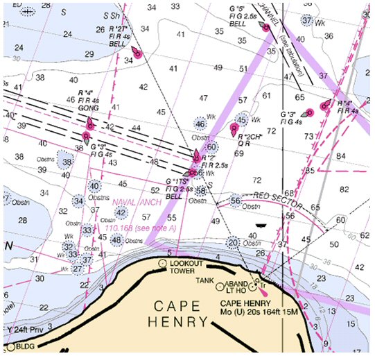
A chart, especially a nautical chart, has special unique characteristics including a very detailed and accurate representation of the coastline, which takes into account varying tidal levels and water forms, critical to a navigator.
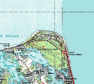
A map emphasizes land forms, including the representation of relief, with shoreline represented as an approximate delineation usually at mean sea level.
   
A chart is a working document. It is used to plot courses for navigators to follow to transit a certain area It takes into account special conditions required for one's vessel, such as draft, bottom clearance, wrecks and obstructions which can be hazardous. Way points are identified to indicate relative position and points at which specific maneuver such as changing courses, must be performed.
A map is a static document which serves as a reference guide. A map is not, and can not be used to plot a course. Rather it provides a predetermined course, usually a road, path, etc., to be followed. Special consideration for the type of vehicle is rarely a consideration. Further, maps provide predetermined points-road intersections-to allow one a choice to change to another predetermined direction
   
Charts provide detailed information on the area beneath the water surface, normally not visible to the naked eye, which can and is very critical for the safe and efficient navigation. 
Maps merely indicate a surface path providing no information of the  condition of the road. For instance a map will not provide information on whether the road is under repair (except when it is a new road) or how many pot holes or other obstructions it may contain. However the driver is able to make a visual assessment of such conditions.
User Survey  | Privacy Policy  |  Disclaimer  |  NOAA's National Ocean Service  |  NOAA  |  U.S. Department of Commerce 
Web site owner: NOAA Office of Coast Survey