Features
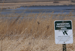
Waterfowl Production Areas (WPAs)
Looking for places to hunt, bird watch, photograph wildlife, see rare native prairie plants or just enjoy the outdoors? Visit a WPA today!
Learn More!
Prairies Conservation Campaign
A coalition of conservation organizations has launched a coordinated, partner-driven “Prairies Conservation Campaign” to bring public attention to the dramatic conversion of grasslands and wetlands to cropland in one of America’s last intact grassland ecosystems – the prairie pothole region.
Learn MoreAbout the Complex
The District is managed out of the headquarters office in Devils Lake, North Dakota.
Devils Lake WMD is managed as part of the Devils Lake Wetland Management District Complex.
Learn more about the complex About the NWRS

The National Wildlife Refuge System, within the U.S. Fish and Wildlife Service, manages a national network of lands and waters set aside to conserve America’s fish, wildlife, and plants.
Learn more about the NWRS
Refuge Updates

NEW FOR 2016! Public access for ice fishing is allowed from 5:00 a.m. to 10:00 p.m. local time in designated areas of the Refuge. Vehicles and fish houses are allowed on the ice as conditions allow. Vehicles are restricted to non-vegetated ice areas and designated roads. Ice fishing shelters and personal property must be removed from the Refuge by 10:00 p.m. each day. Fish houses may not be left unattended in uplands or in parking areas.
The west and south refuge boundaries have been marked with buoys every quarter mile to identify the refuge boundary to those who may be fishing in the neighboring Lake Irvine.
In addition to the buoys there are free mobile apps and GPS downloads available through the North Dakota Game and Fish website that will help identify the refuge boundaries while out on the water. Click the link below to navigate to the downloadable maps.
http://gf.nd.gov/mapsA dynamic arts and science curriculum that teaches wetlands and waterfowl conservation to students in kindergarten through high school.
Participate!
"Double Up for the Ducks" by purchasing two Federal Duck Stamps this season and help conserve more habitat. Follow the link to learn where you can buy Federal Duck Stamps near you.
Learn more
Page Photo Credits — All photos courtesy of USFWS unless otherwise noted.
Last Updated: Jan 29, 2016