
- 12201 Sunrise Valley Drive
- Reston, VA 20192, USA
- 703-648-5953
- 1-888-ASK-USGS
- Employee Directory
- Web Chat
Explore our planet through photography and imagery, including climate change and water all the way back to the 1800s when the USGS was surveying the country by horse and buggy.

Outgoing director, Dr. Robert Rosenbauer (r) congratulating Dr. Guy Gelfenbaum (l) as the new Director of the USGS Pacific Coastal and Marine Science Center.

Dr. Guy Gelfenbaum, geologist and director of the USGS Pacific Coastal and Marine Science Center.

Hydrologic Technician, James Albrecht, from the North Platte Field Office making a measurement of discharge under ice using a Flowtracker acoustic velocity meter on a top-setting wading rod. The string going across the picture is a tagline, used for measuring distance across the channel so that...

The Molecular Ecology Lab at the Fort Collins Science Center

A U.S. Geological Survey field crew uses an Acoustic Doppler Current Profiler to measure water velocity on the Truckee River in Reno, Nevada.

Since mid-December 2016, roughly two dozen wildfires in the Pampas region of Argentina have consumed almost 2.5 million acres while unleashing giant plumes of dense smoke above the rural landscapes.
Likely caused by thunderstorms that followed a stretch of severe drought in the winter and...

Morning snowfall at the Leetown Science Center's Administration building.

A new atlas named Landscapes of West Africa: A Window on a Changing World tells the story of transformations and trends across many lands in West Africa, including this look at the threat of human activities in the...

Large storm waves crashing on the rocks near Santa Cruz, California

Sandy beach and cliffs at Moss Landing, California

USGS scientist Robert Baskin takes a boat out on the Great Salt Lake to conduct research.
Baskin is being awarded with a 2016 Governor’s Medal for Science and Technology. Gov. Gary R. Herbert will present awards to 11 individuals and one company at the 30th anniversary awards dinner on...

Ocoee River, Tennessee

Tree rings dating to the mid-1500s from a ponderosa pine log collected near Taos, NM.

Wind turbines and a rainbow towering high above trees on an island in Hawaii. Paul Cryan, USGS, Fort Collins Science Center.

These larval black-legged ticks, about two months old, were photographed in leaf litter in eastern Tennessee. Photo: Graham Hickling, University of Tennessee

Ticks seek hosts to feed upon by leaning back on their rear legs with front legs outstretched. When a host brushes against the outstretched legs, the tick quickly climbs aboard. The behavior is called “questing.” Photo: Graham Hickling, University of Tennessee

Dissected guano pellet showing antennae, eyes, and body fragments of midges.

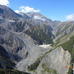
Photograph showing landslides covering State Route 1 near Ohau Point. The route was impacted my several landslides and is the main north-south highway on the eastern part of the South Island of New Zealand.
As many as 80,000 landslides occurred as the result of a magnitude 7.8 earthquake...
Photograph showing a landslide-dammed lake in the headwaters of the Hapuku River in the Seaward Kaikoura mountain range in New Zealand.
As many as 80,000 landslides occurred as the result of a magnitude 7.8 earthquake in New Zealand in November of 2016. The earthquake and landslides...

Photograph showing Papatea Fault surface rupture near Waipapa Bay in New Zealand. The fault moved about 10 m horizontally and uplifted shoreline platform about 2 m at this location.
As many as 80,000 landslides occurred as the result of a magnitude 7.8 earthquake in New Zealand in...

The South Platte River at 104th Street bridge in Denver, CO. Photo by Lindsay Reynolds, USGS.

The South Platte River at the 52 Bridge. Photo by Laura Perry, USGS.

Black and white Tegu lizard in the Florida Everglades grass.

USGS research geologist Jon Warrick explains how his team applied structure-from-motion analysis to photos from the California Coastal Records Project to measure coastal change. Jon Warrick explains a “difference map” constructed from structure-in-motion data. Red areas indicate loss of material...

Framework banner for MAP. Image by Alexe Dacurro

Inline water-use flow meter being installed by Lower Mississippi-Gulf and Arkansas Natural Resources Commission staff

Waterborne resistivity survey in progress on the Tallahatchie River, Leflore County, Mississippi. GPS unit and depth sounder are visible attached to the front of the boat. Photo by James R. Rigby, 2016

View of the Ohmmapper system electrodes being pulled behind a small truck in order to map the near surface geology of Sunflower County, Mississippi near the town of Shellmound. Photo by Ben Miller, 2016

Jason Payne driving an ATV pulling an array of electrodes for mapping the near surface geology in the vicinity of Steiner, Mississippi.

Waterborne resistivity crew conducting a resistivity survey of the Quiver River, Sunflower County, Mississippi. Electrodes on a floating cable are visible behind the boat, which is travelling upstream. Photo by Ben Miller, 2016

A Chinese firebelly newt (Cynops orientalis), the salamander species recently found to be infected with the spring viraemia of carp virus, or SVCV.

A Chinese firebelly newt (Cynops orientalis), the first salamander species found to be infected with the spring viraemia of carp virus.

Erika Lozano, Marcie Cruz, and Emma Hanslowe (L-R), prepare an Argentine black-and-white tegu (Tupinambis merianae) for surgery as part of a study on cold-weather behavior on the lizards.

Sarah Moy conducts radio telemetry on Argentine black-and-white tegus (Tupinambis merianae) in the Florida Everglades. USGS photo.

Jillian Josimovich stands in front of a snake rack she built to house 60 hatchling Burmese pythons (Python molurus bivittatus). Josimovich carried out a research project to examine how these snakes optimize growth. USGS photo.

Molly Conway uses a burrow camera to visualize a Burmese python (Python molurus bivittatus) in a burrow in Everglades National Park. USGS photo.

Alejandro Grajal-Puche shows an Argentine black-and-white tegu (Tupinambis merianae) with a radio-transmitter backpack over its pelvis. USGS photo.

This image is of a perfect row in a field with a USGS Gage in the background. The image was taken by Shane Stocks out of the LMG Jackson, MS office.

JJ Thordsen (USGS) and a wireline operator retrieving downhole vacuum sampler from a characterization well near a CO2 injection well at Citronelle oil field, Alabama.

A sunset in western Loveland, Colorado.

A view of the highway going over Loveland Pass in Colorado.

A landscape view of the "Devil's Backbone" near Loveland, CO.

Chaco Culture National Historical Park, New Mexico.

Alaska Interior mountain range shot with snow capped mountains.

Example of a closed canopy plantation logged 60 years ago at the HJ Andrews Experimental Forest in Oregon, old growth forests have bigger trees and a more complex understory.

Sarah Frey, a Northwest Climate Science Center graduate fellow at Oregon State University, records information during a point count at the H. J. Andrews Experimental Forest in Oregon.

Landsat 7's Enhanced Thematic Mapper Plus (ETM+) sensor captured the image that shows the white covering on the caramel-colored landscape southwest of the Algerian community of Ain Sefra, a town sometimes referred to as the gateway to the...

Acoustic Doppler Current Profiler (ADCP) to measure streamflow
—————————————————————————————————
The use of acoustic Doppler current profilers (ADCPs) from a moving boat is now a commonly used method for measuring streamflow. The technology and methods for...