


AMSR-E Joint Science Team Meeting, McMenamins/Edgefield, Troutdale, OR
11 & 12 September 2012
AMSR-E Joint Science Team Meeting, Asheville, NC,
June 28-29, 2011

AMSR-E LANCE Products
(near-real time)
AMSR-E Data: Google Earth
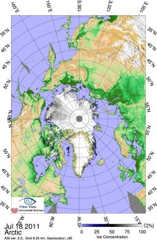
 Sea Ice
Daily Concentraion and Extent
Past 30 days (KML, 46 KB)
Past 60 days (KML, 84 KB)
Past 90 days (KML, 122 KB)
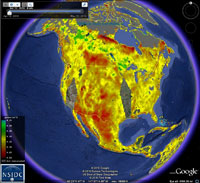
Global Daily Soil Moisture
Past 30 days (KML, 43 KB)
Past 60 days (KML, 72 KB)
Past 90 days (KML, 115 KB)
AMSR-E Joint Science Team Meeting,Huntsville, AL,
June 2-3, 2010
Updated ATBD's
July 2007 Sea Ice ATBD
July 2007 Ocean ATBD Supplement

AMSR-E Brochure
| The Aqua AMSR-E is a cooperative effort between
NASA and the National Space Development Agency (JAXA) of Japan,
with the collaboration of scientific and industry organizations
in both countries. + download pdf |
AMSR-E logo
+ download jpg
The AMSR-E antenna stopped spinning at 0726GMT Oct 4, most likely due to aging lubricant in the mechanism. AMSR-E is currently not producing any data. The Aqua spacecraft accommodated the spin-down, which occurred over a period of about 25 minutes, and continues to operate normally, with all other instruments functioning in science mode. NASA will work with JAXA to understand the condition of the AMSR-E instrument and possible future steps.
_______________________________________________________
 In
support of the Earth Science Enterprise's goals, NASA's
Earth Observing System (EOS) Aqua Satellite was launched
from Vandenberg AFB, California on May 4, 2002 at 02:54:58
a.m. Pacific Daylight Time. The primary goal of Aqua, as
the name implies, is to gather information about water in
the Earth's system. Equipped with six state-of-the-art instruments,
Aqua will col
In
support of the Earth Science Enterprise's goals, NASA's
Earth Observing System (EOS) Aqua Satellite was launched
from Vandenberg AFB, California on May 4, 2002 at 02:54:58
a.m. Pacific Daylight Time. The primary goal of Aqua, as
the name implies, is to gather information about water in
the Earth's system. Equipped with six state-of-the-art instruments,
Aqua will col lect data on global precipitation, evaporation,
and the cycling of water. This information will help scientists
all over the world to better understand the Earth's water
cycle and determine if the water cycle is accelerating as
a result of climate change.
lect data on global precipitation, evaporation,
and the cycling of water. This information will help scientists
all over the world to better understand the Earth's water
cycle and determine if the water cycle is accelerating as
a result of climate change.
The Advanced Microwave Scanning Radiometer - EOS (AMSR-E)
is a one of the six sensors aboard Aqua. AMSR-E is passive
microwave radiometer, modified from the Advanced Earth Observing
Satellite-II (ADEOS-II) AMSR, designed and provided by JAXA
(contractor: Mitsubishi Electric Corporation). It observes
atmospheric, land, oceanic, and cryospheric parameters,
including precipitation, sea surface temperatures, ice concentrations,
snow water equivalent, surface wetness, wind speed, atmospheric
cloud water, and water vapor.
AMSR-E Data Access and Use
|
 NASA Short-term Prediction Research and Transition Center NASA Short-term Prediction Research and Transition CenterAMSR-E CONUS Rain Rate |
 Institute of Oceanography Institute of Oceanography University of Hamburg AMSR-E sea ice concentration |
CERSAT : AMSR-E Sea-Ice Drift Vectors
Arctic Regional Ocean Observing System, Bergen, Norwya
|
