
Data Announcements

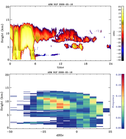
KAZR-ARSCL and KAZRCOR Products Now Available for 2011-2014 Data
Published: 16 November 2016
The Active Remote Sensing of Clouds product using Ka-band ARM Zenith Radars (KAZR-ARSCL) value-added product (VAP) and KAZR Corrected Data (KAZRCOR) VAP together are successors to the retired ARSCL VAP.
The ARSCL VAP was based on the
Millimeter Wavelength Cloud Radar (MMCR), ARM’s original vertically-pointing cloud radar. ARSCL processing optimized MMCR reflectivities and mean Doppler [...]

New WACR Radar Data Available for AWARE Campaign
Published: 16 November 2016
The W-band ARM Cloud Radar-Active Remotely-Sensed Cloud Locations (WACR-ARSCL) provides cloud boundaries and best-estimate time-height fields of radar moments. WACR observations are corrected for velocity aliasing, and then significant detection masks are produced. The corrected WACR measurements are combined with observations from the micropulse lidar, ceilometer, soundings, rain gauge, and [...]

New Scanning ARM Cloud Radar – Advanced – Velocity Azimuth Display (SACR-ADV-VAD) Product Released to Evaluation
Published: 16 November 2016
The Scanning ARM Cloud Radar-Advanced-Velocity Azimuth Display (SACR-ADV-VAD) value-added product (VAP) provides profiles of horizontal wind estimates at cloud level, using observations from the Hemispherical Sky Range Height Indicator (HS-RHI) scan strategy of the Ka-Band Scanning ARM Cloud Radar (KASACR).
The VAD technique was historically used to retrieve wind field properties using weather [...]

Alpha 1 of ARM’s New Modeling Effort Now Released
Published: 31 July 2016
In May 2015, the Department of Energy (DOE) Atmospheric Radiation Measurement (ARM) Climate Research Facility began a pilot project to design a routine, high-resolution modeling capability to complement ARM’s extensive suite of measurements at the Southern Great Plains megasite. This large-eddy simulation (LES) modeling capability has been named LASSO—the LES ARM Symbiotic Simulation [...]

Data Quality Assessment for ARM Radiation Data (QCRAD) VAP Now Operational
Published: 31 July 2016
The Data Quality Assessment for ARM Radiation Data (QCRAD) value-added product (VAP) is now running operationally for the ARM Mobile Facility deployment at Oliktok Point, Alaska, and Eastern North Atlantic site in the Azores. QCRAD has long been the recommended ARM datastream for broadband surface irradiance measurements.
This VAP applies multiple data quality checks, applies a correction for [...]
New Release of Radar CFAD Data Product for ARM Radar Simulator
Published: 31 July 2016
An ARM cloud radar simulator was developed to facilitate direct comparison of climate model output with the ARM ground-based cloud radar measurements by considering limitations and features of the observing process. As part of the effort, this global climate model oriented ARM cloud radar data product, the Contoured Frequency by Altitude Diagram (CFAD), is produced to compare with the ARM radar [...]

Reprocessed Quality Controlled Eddy Correlation Flux Measurement VAP for GoAmazon
Published: 31 July 2016
Quality Controlled Eddy Correlation Flux Measurement (QCECOR) value-added product data were reprocessed for the first ARM Mobile Facility (AMF1) deployment at Manacapuru, Brazil, from April 2014 to December 2015, as a critical component of a two-year scientific collaborative field campaign, the Green Ocean Amazon (GoAmazon) 2014/15. The QCECOR data provide surface sensible and latent heat flux [...]
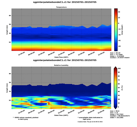
New Version of Interpolated Sounding VAP Released
Published: 9 May 2016
A new version of the Interpolated Sounding (INTERPOLATEDSONDE) value-added product (VAP) is released for use with historical data and current production.
The INTERPOLATEDSONDE VAP transforms sounding data into continuous daily files on a fixed time-height grid at one-minute time resolution from the surface up to a limit of approximately 40 kilometers. The grid extends to 332 levels in order to [...]

MWRRET Version 2 Evaluation Data Available for Southern Great Plains
Published: 9 May 2016
The optimal estimation retrieval of liquid water path (LWP) and precipitable water vapor (PWV) have now been applied to the new 3-channel microwave radiometer at Southern Great Plains (SGP). Data for 2015 are now available as an evaluation product, called the Microwave Radiometer Retrieval version 2 (MWRRETv2), with plans to be an operational VAP within the next year.
The evaluation product [...]

Version 2 of the Continuous Large-Scale Forcing Data Now Available
Published: 9 May 2016
Version 2 of the continuous large-scale forcing data value-added product known as VARANAL for the Southern Great Plains has been released for the year 2012 and for June through August 2015. This product includes both the large-scale forcing terms and the evaluation fields, which can be used for driving single-column models and cloud resolving models and validating model simulations.
This version [...]