Welcome to the USGS Illinois Water Science Center. These pages are your source for water-resource information collected and interpreted
by the U.S. Geological Survey in Illinois.
On the map to the left, point to one of the stream-monitoring locations to see a summary of current streamflow conditions, or click elsewhere on the map to open a larger view.
Illinois Highlights
U.S. Geological Survey data releases are available in the ScienceBase Catalog. ScienceBase houses stand-alone datasets or datasets that support findings in interpretive publications, such as USGS Scientific Investigation Reports or journal articles. These datasets are available for download and are fully documented with metadata. The Illinois-Iowa Water Science Center data releases are listed on a community page within the ScienceBase Catalog.
New Equations for estimating peak discharges in urban basins added to Illinois StreamStats. See more information in the Illinois Center for Transportation (ICT) newsletter featured here.
Ryan Adams of the USGS was quoted in a Chicago Tribune article highlighting projects in Gary, IN as a result of the 2014 Great Lakes Restoration Initiative Shoreline Cities Grant from the U.S. Environmental Protection Agency.
When a moving barge encounters small fish in the Illinois Waterway there is a possibility that the fish will become trapped in the gap between barges, according to a new study by the U.S. Fish and Wildlife Service and the U.S. Geological Survey.
New Illinois Water Science Center Publications!

USGS Data Series 997: Groundwater Quality Data from the National Water-Quality Assessment Project, May 2012 through December 2013
Arnold, T.L., DeSimone, L.A., Bexfield, L.M., Lindsey, B.D., Barlow, J.R., Kulongoski, J.T., Musgrove, MaryLynn, Kingsbury, J.A., and Belitz, Kenneth, 2016, Groundwater quality data from the National Water-Quality Assessment Project, May 2012 through December 2013: U.S. Geological Survey Data Series 997, 56 p.

The U.S. Geological Survey collected bathymetric data in Lake Calumet and a portion of the Calumet River in the vicinity of Lake Calumet to produce a bathymetric map. The bathymetric survey was made over 3 days (July 26, September 11, and November 7, 2012). Lake Calumet has become a focus area for Asian carp rapid-response efforts by state and federal agencies, and very little bathymetric data existed prior to this survey. This bathymetric survey provides data for a variety of scientific and engineering studies of the area; for example, hydraulic modeling of water and sediment transport from Lake Calumet to the Calumet River.
Duncker, J.J., Johnson, K.K., and Sharpe, J.B., 2015, Bathymetric survey of Lake Calumet, Cook County, Illinois: U.S. Geological Survey Scientific Investigations Map 3330, 1 sheet
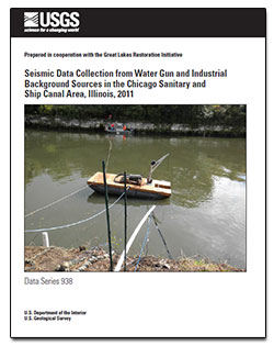
The water gun is a tool adapted from deep marine geophysical surveys that is being evaluated for use as an acoustic fish deterrent to control the movement of invasive marine species. The water gun creates a seismic signal by using a compressed air discharge to move a piston rapidly within the water, resulting in an implosion. This energy pulse may be able to modify fish behavior or destroy marine life, such as the Asian carp, at some distance. The effects of this energy pulse on structures in the Chicago Sanitary and Ship Canal (CSSC), such as canal walls, shore lines, and lock structures, are not known. The potential effects of the use of a water gun on structures was identified as a concern in the CSSC and was assessed relative to existing background sources during this study. During September 2011, two water guns with piston sizes of 80 and 343 cubic inches, respectively, were tested in the CSSC at varying pressures and distances from a canal wall consisting of dolomite and dolomite setblock. Seismic data were collected during these water gun firings using geophones on land, in boreholes, and at the canal wall interface. Data were collected at varying depths in the canal water using hydrophones. Seismic data were also collected during the occurrences of barge traffic, railroad traffic located near the electric fish barrier in Lemont, and coal-loading operations at a coal power plant near the electric fish barrier. In general, energy produced by barge and railroad sources was less than energy created by the water gun. Energy levels produced by coal-loading operations at least 200 feet from geophones were approximately four times lower than energy levels measured during water gun operations.
Morrow, W.S., Carpenter, P.J., and Adams, R.F., 2015, Seismic data collection from water guns and industrial background sources in the Chicago Sanitary and Ship Canal Area, Illinois, 2011: U.S. Geological Survey Data Series 938, 23 p.

USGS Data Series 1009: Groundwater quality at the Saline Valley Conservancy District well field, Gallatin County, Illinois: U.S.
Gorczynska, Magdalena, and Kay, R.T., 2016, Groundwater quality at the Saline Valley Conservancy District well field Gallatin County, Illinois: U.S. Geological Survey Data Series 1009, 13 p.

Application of hydrogeology and groundwater-age estimates to assess the travel time of groundwater at the site of a landfill to the Mahomet Aquifer, near Clinton, Illinois, with a section on Regional Indications of Recharge to the Mahomet Aquifer from Previously Collected Tritium and Pesticide Data, by Buszka, P.M. and Morrow, W.S.
Kay, R.T., and Buszka, P.M., 2016, Application of hydrogeology and groundwater-age estimates to assess the travel time of groundwater, Illinois: U.S. Geological Survey Scientific Investigations Report 2015�5159, 54 p.

Geology, hydrology, water quality, and potential for interbasin invasive-species spread by way of the groundwater pathway near Lemont, Illinois
Kay, R.T., Mills, P.C., and Jackson, P.R., 2016, Geology, hydrology, water quality, and potential for interbasin invasive-species, Lemont, Illinois: U.S. Geological Survey Scientific Investigations Report 2016�5095, 91 p.

Hydrogeology and groundwater quality at monitoring wells installed for the Tunnel and Reservoir Plant System and nearby water-supply wells, Cook County, Illinois
Kay, R.T., 2016, Hydrogeology and groundwater quality at monitoring wells installed for the Tunnel and Reservoir Plant System and nearby water-supply wells, Cook County, Illinois, 1995-2013: (Ver. 1.1 May 2016): U.S. Geological Survey Scientific Investigations Report 2015�5186, 347 p.

Hydrogeologic Framework of LaSalle County, Illinois
Kay, R.T., Bailey, C.R., 2016, Hydrogeologic framework, LaSalle County, Illinois: U.S. Geological Survey Scientific Investigations Report 2016�5154, 97 p.
More New Publications!
Garcia, T., Murphy, E. A., Jackson, P. R., & Garcia, M. H. (2015). Application of the FluEgg model to predict transport of Asian carp eggs in the Saint Joseph River (Great Lakes tributary). Journal of Great Lakes Research.
Sharpe, J.B. and Soong, D.T., 2015, Lake Michigan Diversion Accounting Land Cover Change Estimation by Use of the National Land Cover Dataset and Raingage Network Partitioning Analysis, U.S. Geological Survey Open-File Report 2014-1258.
Mills, P.C., and Cobb, R.P, 2015, Hexavalent and total chromium at low reporting concentrations in source-water aquifers and surface waters used for public supply in Illinois, 2013: U.S. Geological Survey Scientific Investigations Report 2015�5020, 58 p.
New Madrid Quake Potential Elevated
An updated USGS Report says the New Madrid Seismic Zone has a larger range of potential earthquake magnitudes than previously imagined.
USGS Illinois Water Science Center Has New Address
405 N Goodwin Urbana, IL 61801

CAN YOU FEEL IT?
If you feel an earthquake, here is the link to the popular USGS webpage to report what you felt: http://earthquake.usgs.gov/earthquakes/dyfi/


