Warning: Javascript must be enabled to use all the features on this page!
Page Loading - Please Wait...
- Dec 14, 2016 - HTTPS/SSL has been implemented for Water Data for the Nation. Please see news on new formats
-
Full News

Page Loading - Please Wait...
LOCATION.--Lat 41o49'07", long
71o42'20", Providence County, RI, Hydrologic Unit
01090004, on left bank, 5 ft downstream from bridge on Elmdale Road, on
Rams Tail Road, 0.4 mi upstream from Barden Reservoir, and 0.3 mi south
of South Foster.
DRAINAGE AREA.--14.0 mi2.
WATER-DISCHARGE RECORDS
PERIOD OF RECORD.--March 1994 to current year.
GAGE.--Data Collection Platform with telephone telemeter.
Elevation of gage is 355 ft above National Geodetic Vertical Datum of
1929, from topographic map.
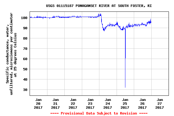
WATER-QUALITY RECORDS
| Boating safety tips |
![]() U.S. Department of the Interior |
U.S. Geological Survey
U.S. Department of the Interior |
U.S. Geological Survey
Title: USGS Current Conditions for the Nation
URL: https://waterdata.usgs.gov/nwis/uv?
Page Contact Information: Massachusetts Water Data Support Team
Page Last Modified: 2017-01-27 02:22:59 EST
4.04 0.91 vaww02