
Principal Investigator: Mary Yoklavich
Co-Principal Investigators: David Huff
External Collaborator: Milton Love (University of California Santa Barbara)
Rocky areas on the continental shelf and upper slope off central and southern California are dominated by more than 40 species of rockfishes, some of which have been declared overfished or are in a rebuilding status. Sedentary rockfishes living in high-relief rocky habitats are particularly difficult to appraise accurately with conventional fisheries-dependent methods. Effective management requires spatially explicit information on the distribution and abundance of these species coupled with components of their habitat (such as depth and substratum type). In this study, we will spatially integrate archived data that was collected during visual surveys of rockfishes with broad-scale seafloor habitat data to create predictive models and maps of fish density and biomass.
The first objective of this research is to advance the spatial models of rockfishes and habitats that we have been developing off central California, which were the result of a previous Habitat Science funded project (Relating Population Abundance of Groundfish Species to Habitats Using Predictive Models and Broad-scale Seafloor Maps). This project will extend the geographic and temporal scope of these efforts in support of stock and habitat assessments relevant to NOAAs Habitat Blueprint Southwest Regional Initiative in the Southern California Bight (SCB). The second objective is to examine temporal trends in biomass for rockfishes in areas of critical habitat (e.g., The Footprint Marine Protected Area [MPA], comprising a rocky seamount within the Channel Islands National Marine Sanctuary).
During the last 17 years, we have surveyed diverse groundfish assemblages and associated habitats in deep water (20-400 m) on rocky banks in the Southern California Bight using direct observation methodologies from occupied submersibles equipped with multiple video cameras and lasers (for measurements). We have now collected spatially referenced information on identification, densities, and size composition of rockfishes and other demersal fishes and associated habitat from more than 400 submersible dives comprising at least 1,100 well navigated and quantified strip transects in the SCB. Several of these dives/transects were conducted annually at specific sites (such as The Footprint MPA); these particular data will be used in spatio-temporal analyses. All of these data are held in a comprehensive database. Coastwide seafloor habitat maps of substratum type and depth have been developed for the 5-year review of West Coast groundfish essential fish habitat (EFH). Environmental variables for predictive modelling and mapping at each location will be quantified at multiple scales.
This geographic expansion of our spatially predictive models will help improve the assessments of a number of demersal fish species with increased occurrence in southern California (e.g., cowcod, boccacio, greenspotted, greenblotched, and starry rockfishes) and identify their critical habitats. Further, our use of fisheries-independent observations from visual surveys will be particularly useful in the absence of fisheries-dependent data from inside numerous fishery closures located in the Southern California Bight (e.g., Cowcod Conservation Areas; EFH closures). Our results will have direct applications to coastal and marine spatial management to address such needs as (1) the design and monitoring of MPAs, (2) identification of EFH, and (3) identification of areas important to the restoration or rebuilding of depleted stocks. Development of models of co-occurring species and associated habitats will have application to ecosystem-based management, providing information needed to manage a more complete demersal fish community.
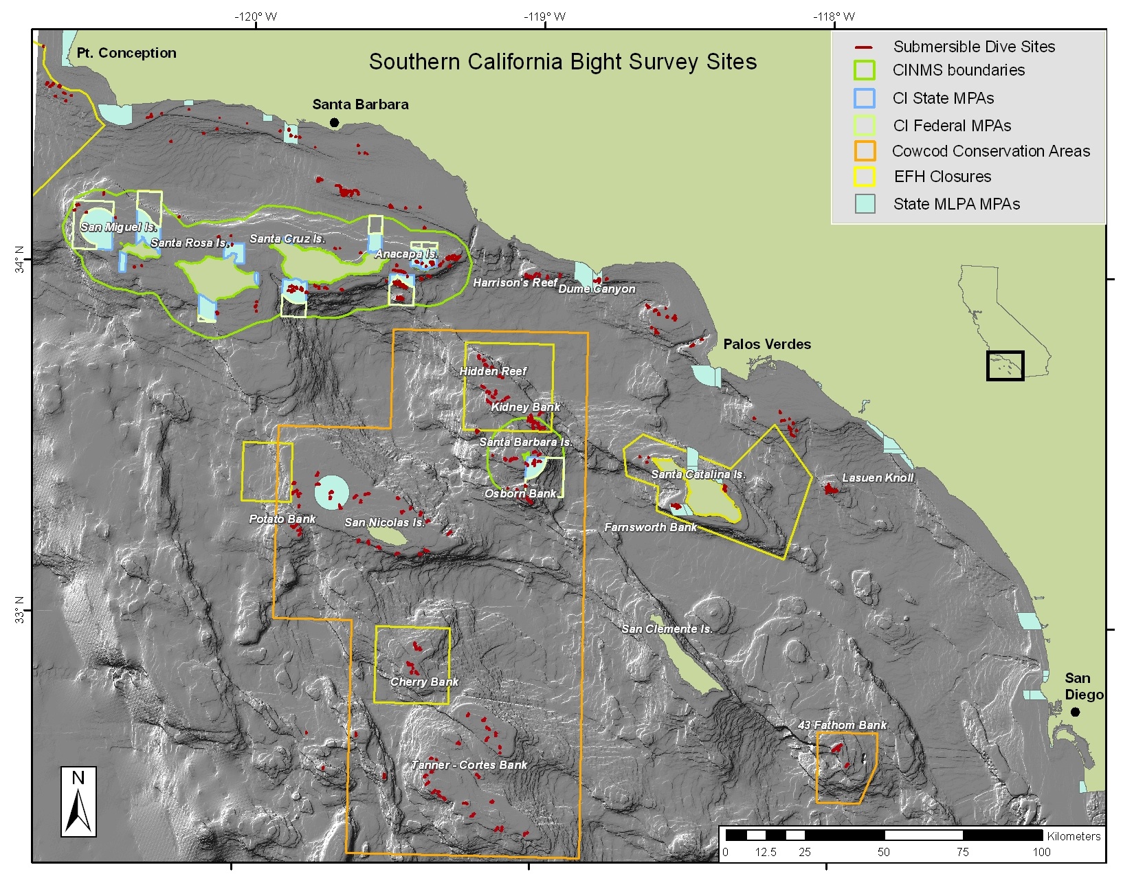
Numerous closed areas in the Southern California Bight protect demersal fish species and their seafloor habitats from extractive and destructive fishing activities. Data on fishes and the physical and biogenic components of their habitat have been collected during visual surveys from manned submersibles within and outside these closed areas over increasing time of protection.