


National Forecast Charts Legacy Page:
Valid Sun Jan 22, 2017
Valid Mon Jan 23, 2017
Valid Tue Jan 24, 2017

Image Format:


+ Additional Links
- » Description of the National Forecast Chart
- » Product Archives
- » Download hazards in KML or shapefile format


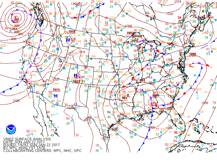
North American Surface Analysis Legacy Page:
Analyzed at 00Z Sun Jan 22, 2017
Analyzed at 03Z Sun Jan 22, 2017
Analyzed at 06Z Sun Jan 22, 2017
Analyzed at 09Z Sun Jan 22, 2017
Analyzed at 12Z Sun Jan 22, 2017
Analyzed at 15Z Sun Jan 22, 2017
Analyzed at 18Z Sun Jan 22, 2017
Analyzed at 21Z Sun Jan 22, 2017
Analyzed at 00Z Mon Jan 23, 2017
Image Format:


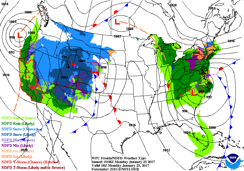
Surface Fronts and Sea-Level Pressures Legacy Page:
Analyzed 00Z Mon Jan 23, 2017
Valid 06Z Mon Jan 23, 2017
Valid 12Z Mon Jan 23, 2017
Valid 18Z Mon Jan 23, 2017
Valid 00Z Tue Jan 24, 2017
Valid 12Z Tue Jan 24, 2017
Valid 00Z Wed Jan 25, 2017
Valid 12Z Thu Jan 26, 2017
Valid 12Z Fri Jan 27, 2017
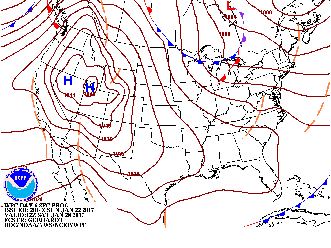
Valid 12Z Sat Jan 28, 2017
Valid 12Z Sun Jan 29, 2017
Valid 12Z Mon Jan 30, 2017


+ Short Range Forecast Discussion (Day ½-2½)
+ Medium Range Forecast Discussion (Day 3-7)
+ Additional Links
Short Range Forecast Discussion
NWS Weather Prediction Center College Park MD
333 PM EST Sun Jan 22 2017

Valid 00Z Mon Jan 23 2017 - 00Z Wed Jan 25 2017

...There is a slight risk of severe thunderstorms over the
Southeast into parts of the Southern Mid-Atlantic with an embedded
region of moderate and high risk...

...Heavy rain possible along the Southern California Coast...

...Heavy snow for the Sierras...

...Heavy rain over parts of Southern New England...

Low pressure over the Southern Appalachians will move
northeastward to off the Mid-Atlantic Coast by Tuesday.  Showers
and thunderstorms will develop over parts of the Southeast through
Monday morning, some of the thunderstorms will be severe.  Rain
will also develop over parts of the Lower Mississippi Valley to
Southeast and parts of the Great Lakes/Ohio Valley along with
parts of the Mid-Atlantic that will end over the Lower Mississippi
Valley by Monday and over the Southeast overnight Monday.  The
rain will also end over most of the Ohio Valley by Tuesday
morning.  Snow will develop over parts of Maine on Sunday evening
that will expand into parts of the Lower Great Lakes and Central
Appalachians that will become a wintry mix of snow, sleet, and or
rain/freezing rain overnight Monday into Tuesday.

Meanwhile, a deep upper-level low just off the Northwest Coast
will move eastward to the Central High Plains by Tuesday.
Moisture flowing into Southern/Central California will slowly
weaken overnight Sunday.  The storm will produce coastal rain and
higher elevation snow over the Pacific Northwest and snow over the
Northern Rockies that will wane on Monday.  Rain and higher
elevation snow will also develop over California and snow over the
Western Great Basin that will start to wane by Tuesday morning.
Snow and lower elevation rain will develop over parts of the Great
Basin, Southwest that will move into parts of the Central/Southern
Rockies by Monday morning.  In addition, snow and rain will
develop over parts of the Northern/Central Plains by Monday
evening continuing through Tuesday.


Ziegenfelder


Graphics available at www.wpc.ncep.noaa.gov/basicwx/basicwx_wbg.php
EXTENDED FORECAST DISCUSSION
NWS WEATHER PREDICTION CENTER COLLEGE PARK MD
1035 AM EST SUN JAN 22 2017

VALID 12Z WED JAN 25 2017 - 12Z SUN JAN 29 2017

...GENERAL FLOW PATTERN/MODEL EVALUATION...

IN THE WAKE OF A COASTAL STORM LIFTING AWAY FROM MAINE AND A
SURFACE CYCLONE TRACKING THROUGH THE GREAT LAKES ON
WEDNESDAY...THE PATTERN WILL BECOME FAIRLY QUIET OVER THE LOWER 48
DURING THE LATER HALF OF THE WEEK AND INTO NEXT WEEKEND.  A BROAD
TROUGH CARVING OUT OVER THE EASTERN HALF OF THE NATION WILL HELP
PLUNGE A FRONTAL BOUNDARY WELL SOUTH INTO THE GULF OF
MEXICO...WHILE UPPER RIDGING AND SURFACE HIGH PRESSURE ARE
EXPECTED TO BUILD IN AND HOLD STRONG OVER THE WESTERN U.S..

THERE REMAINS SOME UNCERTAINTY WITH THE EXACT TIMING OF THE
SURFACE LOW CROSSING THE GREAT LAKES ON WEDNESDAY.  THE WPC
FORECAST STAYED FAIRLY CLOSE TO THE 00Z ECMWF/UKMET/ECMWF ENSEMBLE
MEAN...WHICH HAVE BEEN CONSISTENTLY IN THE MIDDLE OF SLOWER CMC
SOLUTIONS AND FASTER GFS SOLUTIONS WITH THIS FEATURE...AND THE
ECMWF/UKMET/ECMWF ENSEMBLE MEAN ALSO MATCH WELL WITH THE PREVIOUS
WPC FORECAST.  LATER IN THE FORECAST PERIOD...A BLEND OF THE 00Z
GFS/GEFS MEAN AND ECMWF/ECWMF ENSEMBLE MEAN APPEARED TO BEST
ACCOUNT FOR THE GOOD AGREEMENT AMONG DETERMINISTIC GUIDANCE WITH
THE LONGWAVE PATTERN...EVEN OUT THROUGH DAY 7/NEXT SUNDAY...BUT
THE BLEND ALSO SMOOTHED OUT SOME OF THE TIMING/AMPLIFIED
DIFFERENCES THAT DEVELOP WITH IMPULSES OF SHORTWAVE ENERGY DIGGING
INTO THE NORTH CENTRAL U.S. LATER THIS WEEK AND A POSSIBLE PACIFIC
SYSTEM REACHING BRITISH COLUMBIA NEXT WEEKEND.


...WEATHER HIGHLIGHTS/THREATS...

SNOW IS EXPECTED WITH BOTH A COASTAL STORM EXITING MAINE AND
SURFACE CYCLONE TRACKING ACROSS THE GREAT LAKES ON WEDNESDAY...BUT
THEN PRECIPITATION SHOULD BECOME RATHER SPARSE ACROSS THE CONUS
TOWARDS THE LATER HALF OF THE WEEK AND THROUGH NEXT WEEKEND.  AN
EXCEPTION TO THIS WILL BE ACROSS THE GREAT LAKES REGION AND
CENTRAL APPALACHIANS...WHERE COOL/DRY NORTHWESTERLY FLOW WILL
FOSTER LOCALIZED LAKE EFFECT AND UPSLOPE SNOW SHOWERS.
ALSO...PRECIPITATION FROM A SERIES OF PACIFIC SYSTEMS PROGRESSING
TOWARDS WESTERN CANADA COULD IMPACT THE EXTREME NORTHWESTERN
CORNER OF THE NATION...AND MOISTURE RETURNING NORTH OF A FRONTAL
BOUNDARY PLUNGED IN THE GULF OF MEXICO SHOULD INCREASE THE CHANCE
OF PRECIPITATION OVER SOUTH TEXAS AND FLORIDA NEXT WEEKEND.
INITIALLY MILD CONDITIONS IN THE EAST SHOULD TREND COOLER TOWARDS
THE END OF THE WEEK AS A BROAD TROUGH CARVES OUT ALOFT...WHILE
TEMPERATURES WILL STAY BELOW AVERAGE IN THE WEST UNDER AN UPPER
RIDGE (BUT RATHER STRONG SURFACE HIGH PRESSURE).


GERHARDT
Quantitative Precipitation Forecasts Legacy Page:


» View
Probabilistic Precipitation Guidance (Day 1-3)
+ Forecast Discussion (Day 1-3)
+ Additional Links
+ Forecast Discussion (Day 1-3)
QUANTITATIVE PRECIPITATION FORECAST DISCUSSION
NWS WEATHER PREDICTION CENTER COLLEGE PARK MD
527 PM EST SUN JAN 22 2017


FINAL DAY 1...DAY 2 AND DAY 3 QPF DISCUSSION
VALID JAN 23/0000 UTC THRU JAN 26/0000 UTC
REFERENCE AWIPS GRAPHICS UNDER...PRECIP ACCUM - 24HR


DAY 1

18Z UPDATE...
INCREASED AMOUNTS WITHIN EVOLVING COMMA HEAD IN THE SOUTHEAST U.S.
GIVEN MULTIMODEL SUPPORT.  OTHERWISE...NO SIGNIFICANT CHANGES FROM
PRELIM GUIDANCE.

UPPER TN VALLEY---UPPER OH VALLEY--CENTRAL TO SOUTHERN
APPALACHIANS---MID ATLANTIC---COASTAL SOUTHEAST AND CENTRAL TO
SOUTH FLORIDA

THE STRONG CLOSED LOW MOVING FROM THE LOWER MS VALLEY INTO THE
SOUTHEAST THIS AFTERNOON WILL BE LIFTING MORE TOWARD THE NORTHEAST
TONIGHT AND INTO MONDAY ACROSS THE SOUTHEAST AND THE SOUTHERN MID
ATLANTIC.  THE ACTIVE CONVECTION ALONG AND AHEAD OF THE ASSOCIATED
COLD FRONT AND IN THE VICINITY OF NORTHEASTWARD MOVING WARM FRONT
WILL BE PRESSING SOUTHEASTWARD THROUGH FLORIDA TONIGHT AND OFF THE
SOUTHEASTERN COAST.  THE PRECIPITATION DISTRIBUTION AT THAT POINT
WILL THEN BE PREDOMINANTLY IN THE COMMA HEAD/DEFORMATION
PRECIPITATION BAND ON THE WEST AND NORTH SIDE OF THE TRACK OF THE
STRONG CLOSED LOW FROM THE UPPER TN VALLEY---SOUTHERN TO CENTRAL
APPALACHIANS---UPPER OH VALLEY---MID ATLANTIC AND INTO THE EASTERN
LAKES REGION.  WIDESPREAD MODERATE TO HEAVY PRECIP TOTALS LIKELY
ACROSS THESE REGIONS--WHILE MODERATE TO LOCALLY HEAVY PRECIP
TOTALS POSSIBLE THROUGH CENTRAL TO SOUTH FL AND ALONG THE
SOUTHEAST COAST DUE PRIMARILY TO THE EXPECTED QUICK MOVEMENT OF
THE FRONTAL BOUNDARIES ACROSS THESE AREAS.  ABOVE AVERAGE TEMPS
AHEAD OF THIS SYSTEM WILL CONTINUE TO KEEP THE WINTER WEATHER
THREAT CONFINED TO THE NORTHERN PORTION OF THE PRECIP REGION FROM
THE SOUTHERN TIER OF NY INTO NORTHERN PA.  SEE THE LATEST QPFHSD
FOR ADDITIONAL WINTER WEATHER INFORMATION.


CALIFORNIA---SOUTHWEST---GREAT BASIN--CENTRAL ROCKIES

BROAD CYCLONIC FLOW WILL CONTINUE DAY 1 TO THE SOUTH OF THE
SOUTHWARD MOVING MID TO UPPER LEVEL CLOSED LOW OFF THE PACIFIC
NORTHWEST COAST ACROSS LARGE PORTIONS OF THE WEST FROM CALIFORNIA
INTO THE GREAT BASIN---ROCKIES AND SOUTHWEST.  THE AXIS OF MUCH
ABOVE AVERAGE PW VALUES IN THE ATMOSPHERIC RIVER CURRENTLY
IMPACTING CENTRAL TO SOUTHERN CALIFORNIA WILL CONTINUE TO PRESS
SLOWLY EAST SOUTHEASTWARD INTO SOUTHERN CALIFORNIA THIS EVENING
AND INLAND INTO THE SOUTHWEST TONIGHT AND INTO EARLY MONDAY.  IN
THE WAKE OF THE ATMOSPHERIC RIVER---PERSISTENT CYCLONIC ONSHORE
FLOW WILL MAINTAIN SHOWERY CONDITIONS THROUGH CALIFORNIA--INLAND
INTO THE GREAT BASIN AND ROCKIES.  HEAVY PRECIP TOTALS LIKELY OVER
THE SOUTHERN COAST RANGE OF CALIFORNIA AND THROUGH THE SIERRA
EARLY DAY 1---WITH MODERATE TO LOCALLY HEAVY TOTALS INLAND THROUGH
THE FAVORED TERRAIN AREAS OF THE SOUTHWEST---GREAT BASIN AND
CENTRAL ROCKIES.  MODERATE PRECIP TOTALS LIKELY ELSEWHERE ALONG
THE CENTRAL TO NORTHERN CALIFORNIA COAST RANGES.  THIS 24 HOURS
PERIOD MAY BE THE LAST WIDESPREAD MODERATE TO HEAVY PRECIP EVENT
FOR CALIFORNIA INTO THE SOUTHWEST---GREAT BASIN AND CENTRAL
ROCKIES IN THE RECENT VERY WET PATTERN AS AN EXTENDED PERIOD OF
DRIER CONDITIONS IS EXPECTED.


DAYS 2 AND 3...


...WEST COAST...


BROAD CYCLONIC FLOW FROM AN MID TO UPPER LEVEL TROUGH SWINGING
ACROSS THE WEST COAST WILL CONTINUE TO BRING RAIN AND HIGHER
ELEVATION SNOW TO THE SOUTHERN HALF OF CALIFORNIA.  MOST OF THE
PRECIPITATION WILL OCCUR DURING THE FIRST PART OF DAY 2. A STRONG
SHORT WAVE WILL ROUND THE BOTTOM OF THE UPPER LEVEL TROUGH AND
MOVE ACROSS SOUTHERN CALIFORNIA INTO THE EARLY HOURS OF
TUESDAY...BRINGING HEAVY RAIN ACROSS THIS REGION OF CALI.  FOR THE
DAY 2 EXCESSIVE RAINFALL...MULTIPLE MODELS (INCLUDING WPC QPF) WAS
GIVING THIS REGION OVER 1.00 INCHES OF QPF.  THIS AREA IS EXPECTED
TO RECEIVE HEAVY RAINFALL PRIOR TO DAY 2...SO WITH ADDITIONAL
AMOUNTS OF AT LEAST 1.00 INCH FLOODING WILL BE A CONCERN.
THUS...WPC CONTINUED THE SLIGHT RISK FOR DAY 2 EXCESSIVE RAINFALL
OUTLOOK.

BY THE END OF DAY 2 AND BEGINNING OF DAY 3...THE MAIN AXIS OF THE
TROUGH WILL SHIFT OVER THE SOUTHWEST AND TOWARD THE ROCKIES.  SOME
LINGERING PRECIPITATION CAN BE EXPECTED DURING THE FIRST PART OF
DAY 3...HOWEVER AN UPPER LEVEL RIDGE WILL BUILD ACROSS THE WEST
COAST AND CUT OFF THE SUPPLY OF MOISTURE. PRECIPITATION SHOULD END
BY EARLY WEDNESDAY MORNING.  THE 12Z GFS WAS MUCH FASTER WITH THE
PRECIPITATION ENDING ACROSS CALIFORNIA...WHILE THE 12Z ECMWF HAD
PRECIPITATION LINGERING EVEN INTO DAY 3. WPC COMPROMISED AND USED
A BLEND OF THE 12Z GFS/ECMWF.


...CENTRAL AND SOUTHERN ROCKIES/SOUTHWEST...

THE STRONG SHORT WAVE DELIVERING THE HEAVY RAINFALL ACROSS
SOUTHERN CALIFORNIA WILL CONTINUE TO MOVE EASTWARD ACROSS THE
SOUTHWEST AND SOUTHERN/CENTRAL ROCKIES EARLY DAY 2.  WIDESPREAD
QPF AMOUNTS WILL CONCENTRATE AROUND THE FOUR CORNERS REGION AS
MOISTURE FROM THE PACIFIC STILL LINGERS ACROSS THIS REGION AND IS
ENHANCED BY THE TERRAIN.   THE HIGHER ELEVATIONS CAN EXPECT HEAVY
SNOW TO CONTINUE ACROSS THE CENTRAL AND SOUTHERN ROCKIES...ALONG
WITH SOME PARTS OF THE NORTHERN ROCKIES.  AS THE SHORT WAVE EJECTS
OUT INTO THE PLAINS LATER ON INTO DAY 2/DAY 3...THE MOISTURE
SUPPLY WILL BEGIN TO DECREASE.  PRECIPITATION AMOUNTS ACROSS THE
FOUR CORNERS/ROCKIES WILL BEGIN TO TAPER OFF AS A RESULT BY THE
END OF DAY 2.  BY DAY 3...SOME LINGERING LIGHT PRECIPITATION COULD
CONTINUE ACROSS PARTS OF THE CENTRAL ROCKIES.  WPC USED A BLEND OF
THE 12Z GFS/ECMWF.


...NORTHERN PLAINS/UPPER MS VALLEY/UPPER GREAT LAKES...

THE SYSTEM AFFECTING THE WEST COAST/ROCKIES WILL EJECT OUT INTO
THE CENTRAL PLAINS BY TUESDAY...ALONG WITH IT A SURFACE LOW THAT
FOLLOWS GENERALLY THE SAME PATH AND WILL UNDERGO CYCLOGENESIS AS
IT MOVES FROM THE PLAINS TOWARD THE GREAT LAKES.  PWAT VALUES
AHEAD OF THE FRONT WILL BE AROUND 0.5 INCHES.  PRECIPITATION WILL
BEGIN TO DEVELOP AROUND THE SURFACE LOW BY TUESDAY AFTERNOON AND
WILL CONTINUE TO MOVE EASTWARD TOWARD THE UPPER GREAT LAKES BY
WEDNESDAY MORNING.  FOR DAY 2...AN AXIS OF 0.5-0.75 INCHES ALONG
THE NORTHERN/CENTRAL PLAINS WAS PLACED...WITH THIS SHIFTING TOWARD
THE UPPER MIDWEST/GREAT LAKES FOR DAY 3.  IN TERMS OF MODELS...THE
GFS CONTINUED TO BE FASTER AND FARTHER EAST WITH THE PLACEMENT OF
QPF WHILE THE ECMWF CONTINUED ITS CONSISTENCY TO BE FARTHER SOUTH
AND SLOWER.  WPC BASED ITS QPF ON A MOSTLY ON THE 12Z ECMWF WITH
SOME WEIGHT ON THE 12Z UKMET AS IT HAD A SIMILAR OUTPUT OF THE
ECMWF.


...MID ATLANTIC/NORTHEAST...


A STRONG CLOSED MID LEVEL LOW WILL MOVE OUT OF THE MID-ATLANTIC
AND SKIRT THE NEW ENGLAND COASTLINE ON DAY 2.  THE SURFACE LOW
WILL ALSO MOVE INTO THE ATLANTIC AND ALONG THE NEW ENGLAND
COAST...DELIVERING RAINFALL AND WINTRY PRECIPITATION THROUGHOUT
DAY 2/TUESDAY.  PWAT VALUES OF 1.00 WILL BE TRANSPORTED TOWARD
THESE REGIONS AS THE SURFACE LOW MAKES ITS NORTHEASTERLY TRACK
TOWARD NOVA SCOTIA.  WITH THIS IMPRESSIVE AMOUNT OF MOISTURE AND
UPPER LEVEL FORCING...WIDESPREAD PRECIPITATION IS EXPECTED FOR
MUCH OF THE NORTHEAST AND NEW ENGLAND ON DAY 2.  AN AXIS OF
1.00-2.00 INCHES OF QPF WAS PLACED FROM NJ TO THE SOUTHERN TIP OF
MAINE.  ALTHOUGH FFG GUIDANCE WAS HIGH IN THIS REGION...THERE WAS
SOME FFG VALUES THAT WERE LOWER ESPECIALLY IN THE NJ REGION.
CONTINUED THE SLIGHT RISK OF EXCESSIVE RAINFALL IN THIS AREA. AS
THE SURFACE LOW DEEPENS AND MOVES TOWARD NOVA
SCOTIA...PRECIPITATION WILL QUICKLY TAPER OFF BY DAY 3...WITH QPF
STILL IN PLACE OVER NORTHERN MAINE.  WPC QPF WAS BASED ON A BLEND
OF THE 12Z ECMWF/12Z GFS.


GRAPHICS AVAILABLE ON THE WEB AT
WWW.WPC.NCEP.NOAA.GOV/QPF/QPF2.SHTML


ORAVEC/SULLIVAN/REINHART

24HR QP VT 24/00Z
 0.01 400643 402646 404652 408658 416667 426693 428698 430702
      432703 443708 445710 446712 443717 442719 441723 442733
      445743 447751 449753 450758 451769 452786 453796 453801
      455805 458812 461817 464819 466819 469818 471816 485813
      495817 507823 510827 514831 521839 523847 526854 527871
      527882 526890 524906 521914 518918 504916 500913 496908
      495901 495891 495883 496879 496874 494870 494864 490856
      488851 486849 485847 484850 483852 480854 475857 467861
      464863 460865 454869 450872 443874 439875 432876 418877
      410878 403876 393872 387870 382869 372872 367873 365874
      366876 372880 370885 367889 352905 344915 339917 335917
      334916 328914 325909 320900 316892 314886 312877 313872
      313864 314858 316855 315851 314846 326827 328820 324814
      320810 318809 315810 310817 309823 305836 303848 297857
      295860 292860 287860 278865 273865 273863 269859 267853
      265851 266849 266844 268840 266836 262836 255836 248836
      241836 237838 233838 231837 227834 223831 224825 225818
      225811 224805 224799 225788 217786 214785 215782 218777
      220771 225762 233755 251739 260732 266725 278718 289711
      355669 357669 359668 360668 362667 364667 366666 367666
      369665 371664 373664 374663 375662 376661 377659 378657
      379656 380655 381653 382653 383651 383650 385649 386647
 0.01 510207 511196 509190 506185 507177 511150 510145 511136
      510129 508125 506117 504114 499103 496086 496082 495079
      495071 494068 494064 492061 489064 489070 487073 486072
      482069 479071 477077 477095 476104 478109 478118 476121
      473119 470108 462101 462094 461089 458076 457072 455071
      453070 450068 446067 442064 438064 434066 440085 438087
      435085 432083 429082 427079 425074 427070 428065 427059
      424055 418055 416056 413054 409052 403050 396050 392047
      387049 377049 373048 369049 363049 359051 356053 355055
      355062 354077 355082 354085 352086 349087 345087 339084
      334084 330087 327097 325101 323103 320103 310106 307111
      309117 314126 316129 320132 304173 315192 319195 325196
      332202 338210 343218 349226 356234 364243 369246 373248
      385252 390253 396256 402257 406257 417260 441267 467276
      472279 477281 480281 483278 487277 488270 494262 500248
      501241 501237 503233 504225 506217 510207
 0.01 490237 491222 488217 484215 479216 476213 475208 476200
      475193 473189 470185 468183 465182 462181 460183 456182
      451181 449183 450185 451192 450199 451205 453210 464214
      466217 464221 461224 457226 448225 444228 443233 452232
      456232 461234 466236 471235 474232 478230 481233 481239
      483244 486241 488238 490237
 0.01 464129 463127 463126 463124 463121 464119 464117 463114
      462112 461114 460116 459118 459121 458123 458125 458128
      457128 456130 457132 459132 460133 462131 464129
 0.01 464023 462011 460005 456003 455995 452993 450998 449005
      444016 442021 441029 444041 446046 449051 452050 455047
      458042 461037 463031 463027 464023 464023
 0.25 461253 456250 452246 447244 441243 436241 433238 427231
      421229 420225 418219 416215 412212 410207 410203 407199
      404195 403189 407179 411171 417163 421156 427148 430144
      434142 436141 437139 438131 444123 447119 448111 447105
      445101 443098 438095 431090 427086 423086 420089 418094
      413101 412101 413096 411090 409085 406082 406079 409080
      413080 416075 416071 415069 412065 405061 402060 398062
      393062 389061 384061 381066 373061 368059 364062 363067
      364072 368083 371093 373102 377105 377108 371109 367112
      364114 358114 351109 344104 341100 338099 336102 334108
      339128 344140 346150 347155 348158 351158 355158 357163
      354168 353171 352176 350180 348176 348171 350167 348163
      348159 344160 339159 335160 329160 321156 312154 307155
      305159 309167 319180 331185 334189 336193 339201 344208
      355221 359224 364227 373231 390245 399250 408252 417253
      426254 445253 454252 461253
 0.25 436784 426741 425734 428731 424729 423723 420714 419709
      417706 409684 405674 402668 396664 389663 382666 375671
      368678 360684 352687 344690 336692 327696 311704 303710
      295714 289718 282722 275726 270731 257741 243752 237757
      233762 228767 226769 225772 228773 232773 234776 237785
      240796 241800 239804 238811 236820 237825 240827 246826
      257825 267823 272822 277820 284815 297807 312801 322801
      329803 333806 335810 337815 338820 338830 336839 334846
      329852 327857 327863 328874 332878 336879 342875 348870
      351868 355867 362863 368858 383850 391845 398841 405836
      410832 418829 423824 427816 430807 435795 436784
 0.25 413139 412133 409126 406122 400123 393123 388125 385129
      387135 388138 392139 396142 398145 401145 408145 413141
      413139
 0.25 389185 391179 389176 384171 381169 381166 385159 385153
      383151 379151 376152 374152 374157 373162 371165 368167
      368171 373176 377182 384185 389185
 0.25 381215 380211 379209 374206 369201 365198 361194 354191
      352193 353195 355198 360201 364204 368209 373212 378216
      381215
 0.25 388111 388107 387104 388101 388100 387097 383095 381097
      380101 380105 381108 383111 385113 386113 388111
 0.50 431248 429242 424237 413234 410233 410230 414225 415220
      412216 407215 404210 398202 390196 382189 372182 365180
      360179 355180 351183 349184 348182 346176 345168 343164
      333162 328161 323159 311156 309159 311162 314166 320174
      337186 341197 347205 354212 358216 362220 365218 364215
      361210 359206 356202 353199 350194 351187 355189 366195
      371199 374202 382209 391213 403220 407229 390229 387232
      388235 390240 400246 412248 421250 427250 431248
 0.50 439112 439108 437105 434099 430092 428090 425091 427098
      427103 425104 414110 410108 410104 408096 405099 404102
      400106 398106 396108 392112 391115 391117 395118 402118
      407119 413123 415126 419128 424124 433116 439112
 0.50 429795 428786 427780 423768 419760 417755 417750 414728
      414720 412714 409703 405690 401681 398675 395672 389669
      384671 381672 374679 364695 353713 350715 349720 342725
      334723 335716 325718 314720 301723 293728 278737 271742
      265747 259753 253761 241775 242781 242783 245784 253780
      259776 267771 270769 274768 269773 254787 249793 246800
      242808 244813 248814 253815 255818 261818 265817 270814
      271810 267808 265805 276793 289784 297779 306776 313774
      319774 324774 328776 332783 335787 336792 341801 344804
      345810 343831 340844 335852 333856 332862 333867 335869
      340869 343867 350863 358858 365852 374846 381841 394830
      409821 417818 421815 424810 427802 429795
 0.50 421147 421145 419145 419147 417148 417149 417151 417152
      418153 419152 420149 421148 421147
 0.50 393080 393078 393075 393073 392071 392070 391070 390070
      389072 389075 390077 390078 391080 392080 393080
 0.50 385143 383136 380133 379123 377119 365118 359118 354116
      346108 341106 340111 342118 344124 353132 363138 367142
      370147 373148 376148 380144 385143
 0.50 372220 373218 372216 372215 370217 370219 370220 372220
      372220
 0.50 379096 379094 378092 378091 377092 376092 376094 376096
      376097 378098 379096
 0.50 378083 379078 378074 377071 376067 375065 373063 370062
      366063 367067 369068 371072 371075 372080 372082 375084
      378083
 0.50 366157 366155 365153 365152 363151 362152 361154 360156
      361157 361159 362160 364160 365160 366158 366157
 0.50 366773 366771 366769 365767 364767 363766 363767 362769
      363771 364773 366774 366773
 0.50 282763 281762 279763 278763 279763 281763 282763
 0.50 278765 277764 275765 274766 276767 277766 278765
 1.00 405724 396685 391678 387676 384678 379683 375690 359720
      354726 348731 335741 322750 314754 308757 299761 293765
      288770 286774 285779 290779 294777 301773 315766 323762
      332759 339757 348756 360746 368741 373741 383740 387742
      389744 392746 395745 400739 404736 405732 405724
 1.00 412805 408802 401803 396805 391810 388815 385820 383825
      387824 392821 397816 401813 407811 411807 412805
 1.00 398210 392202 386197 380190 373185 366182 361182 357185
      360189 364191 372196 378203 381205 386207 395210 398210
 1.00 406773 402769 397766 393762 392761 390762 384767 381771
      375781 373788 370793 363801 357811 351822 349836 347843
      345848 340852 339855 339859 340860 343860 347855 356848
      361838 362830 364824 368813 376803 384797 396799 400794
      402790 405781 406773
 1.00 406114 406112 407110 405108 404109 403110 402111 402113
      403114 405115 406114
 1.00 376141 376139 376137 376134 376133 376132 376130 376128
      376125 375124 373123 372125 371127 371129 371131 371134
      371136 371138 371140 371141 373143 375142 376141
 1.00 347198 347196 346195 346193 345191 344193 344195 344196
      345198 346199 347198
 1.00 345184 345178 344170 343166 341164 334164 327162 320160
      316161 319167 324171 329175 334178 337181 342185 345184
 1.50 395699 394691 391685 388681 385683 379692 373700 371706
      370711 368717 366721 364726 364731 375731 382730 388728
      390724 392720 394708 395699
 1.50 385200 383196 379193 376191 373187 370185 364184 361186
      364189 369191 372194 375197 378200 383202 385200
 1.50 355739 351737 345739 339742 334745 330748 325753 323754
      324756 329754 336753 343751 349749 353744 355739
 1.50 362818 362816 361816 360819 361819 362818
 1.50 360823 360821 359820 358821 358822 356823 354826 355828
      355830 355832 355835 357833 357832 358830 359828 359825
      360824 360823
 1.50 344182 345176 344171 342166 339166 334165 330164 325163
      321164 323167 326169 329172 333174 336177 339181 343183
      344182
 1.50 319759 319757 318757 318759 319759 319759
 2.00 385710 385705 385701 383699 380699 378701 377703 376707
      375710 375714 375717 376719 378722 381721 383719 384716
      385712 385710
 2.00 373191 373189 372188 371187 369186 368186 366186 364186
      366187 367188 369190 371191 372192 373191
 2.00 344180 344175 344173 343169 341166 338166 334166 330164
      327164 324165 326167 328169 331171 333172 336174 338176
      339179 341179 344180
 3.00 343178 343177 342175 343173 343171 343170 341168 340168
      341170 341173 342175 343177 343178 343178
 3.00 335169 334167 333167 332166 330165 328165 328166 330168
      331168 332169 333170 335169

24HR QP VT 25/00Z
 0.01 424622 454625 473639 479648 484659 488671 490676 491684
      493689 494696 494710 494738 494755 493761 493769 491780
      489785 487790 482797 479800 474801 472803 474805 475807
      478810 483819 488820 493820 502821 512824 520824 529824
      535831 540839 535845 529855 526858 521860 516862 512861
      509862 507864 503865 498866 494866 484865 464866 460864
      457864 451865 441865 431865 420865 401862 393859 387859
      383857 375854 370853 365850 356847 352845 349842 352833
      352828 355824 367809 370804 375801 383796 384792 385789
      383786 378779 371774 366773 362774 360772 359768 356764
      348761 345761 342764 337768 335772 322786 317792 314794
      310794 301790 294786 290782 288778 286771 289767 293757
      296749 302742 307735 317721 323712 330704 340693 347686
      355679 362672 365667 390638 424622
 0.01 558034 558025 557017 554004 552989 549976 546972 542970
      538968 534970 530973 528978 524989 523998 521002 516006
      514009 511014 509020 509037 511050 513056 516061 529076
      532080 538081 542080 545077 553053 556040 558034
 0.01 510167 505164 499163 490160 485152 483149 481144 483139
      485137 487139 490142 491140 480125 480109 478098 476091
      474086 472081 467075 465071 466066 467058 471034 474008
      474984 470975 469968 466962 462952 459946 457940 452932
      449929 448923 447916 446911 442901 439894 434887 428883
      420879 413879 409882 407885 407892 401911 397922 394926
      390924 387924 384922 378922 374920 368920 361924 360931
      360935 362937 368943 370947 371955 373961 375967 377968
      379973 380978 382981 385984 395980 398978 401977 402980
      403986 404991 406994 408000 410013 410021 407027 405030
      400032 394032 389033 382029 380035 384040 390046 394048
      396050 394052 391053 386054 378048 374045 370043 361048
      356049 351048 343051 340049 337052 327055 327060 332062
      336064 342064 348066 349068 347070 341072 333073 329075
      325077 319082 311087 304089 301094 301100 302106 302110
      300112 300118 302123 303134 304138 302144 297150 296157
      298161 306168 314173 311179 312184 313195 313200 315205
      314210 315215 316222 319226 320232 324239 328247 334253
      349266 365277 368279 374281 381283 386282 396280 403277
      410273 414270 417266 423260 427257 427254 423248 417241
      416239 417235 419231 421227 425225 433219 432214 429211
      422205 414202 410201 408199 406196 402193 397191 394193
      392196 388195 380190 376189 373186 366184 369190 373194
      371196 369196 365198 363199 361197 354191 351187 350183
      347171 347167 345166 341163 332160 325159 319152 317147
      319142 323139 328136 332134 336134 341136 344138 350141
      353140 358141 368142 377140 385136 390131 397125 402123
      407126 413129 415135 415139 413144 408149 399150 394151
      391156 399163 402167 407168 413168 420169 422172 427171
      432170 434163 434152 433145 434137 437130 442125 448119
      449122 448125 447131 448136 452138 453142 452146 451154
      454161 457166 462170 467173 471176 475174 482174 487173
      492172 497171 502170 507169 510167 510167
 0.01 468823 463819 459815 452816 447817 442813 440811 437811
      434818 438825 441829 447831 453829 460828 465826 468823
 0.01 403181 404177 404172 402169 401167 397168 395169 393170
      390171 387173 386173 385175 388178 390179 394180 397181
      399183 401182 403181
 0.25 483708 481690 477676 475668 471664 465660 458651 454646
      448646 440645 434646 429645 419644 408646 397650 389656
      384659 381663 376674 375678 371682 367686 364690 362697
      362702 363711 365717 366721 364723 362727 361733 361736
      363736 376733 386738 388739 388742 385747 382751 380757
      384763 388765 394765 398768 403779 407792 411802 414808
      418811 421810 425806 432797 435793 437789 439782 442776
      444772 447768 452769 457767 462765 466762 470757 472750
      475739 480729 483718 483708
 0.25 480839 478837 474836 466838 459841 452844 446848 444854
      447856 451857 460856 468853 475850 478848 479844 480839
 0.25 464028 465016 464008 462001 458993 455988 450983 448976
      447966 443950 440942 437937 432934 427936 424943 423949
      421952 416963 415970 417973 422977 426982 428988 426996
      423001 417015 412031 416035 423036 430047 431050 430053
      426058 424060 420060 414059 400061 395063 389066 382067
      376064 371059 369052 365051 362052 357055 356059 360065
      361073 361078 362081 366083 370088 371092 373090 377085
      386078 393076 400078 406079 410079 412081 414087 417093
      426103 422109 422119 427122 426130 434122 437115 438110
      438105 435098 436093 438091 441090 442086 446079 448076
      451078 454078 455076 457070 458059 458049 459043 460038
      463034 464028
 0.25 426151 426148 427146 427144 427141 426141 426143 425146
      424148 425151 426151 426151
 0.25 410230 412227 411224 407222 407215 405212 400211 399215
      401220 403221 402223 399225 396229 399233 402233 406231
      410230
 0.25 402247 403241 401237 399235 395234 391233 389229 382226
      373223 366220 353213 346208 342208 339210 338213 338217
      342223 346229 349235 352242 354246 357248 360249 363248
      370248 380250 386251 394251 400248 402247
 0.25 395796 393795 391795 390796 388797 386799 387802 388800
      390799 392798 393797 395796
 0.25 385804 386802 385801 384802 383803 381804 381805 380807
      379807 379809 380810 382809 383809 383808 384806 385804
      385804
 0.25 367818 366816 364817 364818 363820 362821 362823 363823
      364823 365822 366820 366819 367818
 0.25 357087 357082 356080 350081 346084 342089 334081 329084
      327089 327094 325098 323102 321104 320108 324111 328116
      332114 335110 340113 342109 342100 342095 349095 357087
 0.25 332169 332168 330167 328167 326167 326168 327170 328171
      330171 330170 332170 332169
 0.50 467692 467684 466680 461668 458662 452654 448654 445657
      443659 440657 432655 425653 418651 408652 399655 393660
      387666 382674 380683 375689 372693 371697 371702 372709
      376716 379719 383720 390721 392722 393725 393731 389748
      408770 413781 418788 421790 426790 432785 436778 440769
      443764 446762 451757 454753 458752 463744 466736 468724
      468716 468707 467696 467692
 0.50 445041 445035 445031 444025 444019 445013 444007 441001
      438999 435999 429004 425008 422018 421021 423025 428029
      433033 438039 441042 445041 445041
 0.50 437973 437971 437969 437966 437964 436963 435961 433961
      431961 430961 429961 428963 428964 428966 428968 429971
      429972 430973 431974 433975 434976 435976 436975 437973
 0.50 365239 366234 366230 365227 363226 360225 356225 354227
      353229 355231 358232 360235 357239 361241 363240 365239
 1.00 452718 434733 432731 431726 431721 432718 441706 445690
      446686 446681 445677 443674 436674 431669 426665 421662
      415660 407662 401666 397671 396679 395683 396689 401704
      402715 401724 396738 397745 402750 413755 417761 420771
      422773 426774 431769 439757 444742 450731 452718
 1.50 441689 441684 438682 435682 433679 428675 421676 416672
      410673 405675 407678 412688 415694 413701 408706 407713
      407717 408723 412727 420723 424719 432708 436702 436695
      441689
 2.00 432704 431697 428694 424697 421701 418704 415707 413711
      410714 413717 418714 423713 426710 429708 432704

24HR QP VT 26/00Z
 0.01 454587 487600 510642 515655 523678 526688 530700 536722
      539734 540748 541761 539772 537783 534792 526799 516801
      506798 500799 496802 492805 490803 487802 481802 479802
      477805 476810 476815 474821 473826 474830 482834 486834
      487831 489828 494827 514825 516825 518830 519837 521839
      521857 521864 519869 516873 516882 513899 512904 510908
      505914 497916 492917 489917 487919 482920 479922 474923
      471927 466932 463945 462956 461962 461966 463969 470968
      476964 492954 500949 507949 510949 511951 511966 506974
      499980 492982 489983 487985 487989 489994 489001 490005
      487007 484007 480007 477009 474007 469006 463006 461010
      461015 459025 451049 444056 440060 437066 437071 438075
      441085 442091 442094 445096 450097 453100 451107 449113
      447116 434126 428132 426134 422131 421128 416127 407124
      390116 397109 400108 403108 410109 418107 426104 427101
      426097 423094 413092 403090 399089 394088 386085 382080
      379076 381073 383069 387065 398057 407052 412050 413047
      412044 410040 406036 402031 402024 402018 403014 404000
      401989 399986 399979 399966 399962 400957 399954 397952
      390950 383945 380943 380940 384929 391915 398908 400906
      401902 401899 398897 396897 394895 392892 397881 409843
      413836 414832 414825 400834 395840 390847 388852 386856
      383857 378857 381848 386840 392830 393828 391826 387824
      386820 387815 391808 400792 412781 418774 422766 429748
      427746 422747 413749 408749 404748 406745 412743 424741
      429738 431735 431731 428729 424731 417736 406739 404736
      403728 404720 408708 411701 416694 419692 421688 423680
      423675 421670 417662 414657 413637 426611 454587
 0.01 509286 511277 509270 505261 495244 490233 487229 484226
      482232 481239 478232 474234 475240 475243 473243 468242
      464241 461242 458246 455248 443249 437248 433244 424229
      420225 413223 409223 404223 395223 387225 382226 378229
      372236 369240 368247 367258 372261 374267 378275 384283
      390289 401294 412298 432305 445310 449311 454311 464316
      469317 474319 484319 488319 491318 498312 502304 509286
 0.01 494143 491137 484133 475126 470120 466124 466129 460133
      455147 453151 452156 452164 456166 459165 461163 464164
      465167 468168 474168 476171 479169 483166 485162 484159
      481153 483147 485145 491146 494143
 0.01 404210 403204 398200 393196 388193 383190 380189 379192
      379195 382197 385200 392203 397207 401211 404210
 0.01 409164 409159 408156 404153 400155 399157 400160 401162
      397163 394162 391162 389163 386168 387174 389176 392177
      398178 403177 405172 404169 404166 409164
 0.01 364207 364201 363197 358193 353188 348183 343181 339181
      336182 336187 339194 340202 344207 347210 351211 356212
      358211 364207
 0.01 350844 351841 350838 346838 343840 339840 334843 328848
      324857 320862 316867 310873 294897 289905 285910 276921
      274925 275931 283932 281938 277943 277948 281952 280957
      280962 283963 286961 291956 296948 300943 309933 319920
      323915 326909 328904 328898 328891 329887 328884 327877
      330869 335863 343851 350844
 0.25 458595 485606 503636 509652 514667 518687 520696 521707
      522720 523731 524741 522749 520756 516757 514756 510755
      507759 503761 499761 495758 491753 488747 482733 480724
      477719 475717 471716 466715 461711 458707 453701 449697
      441689 437684 433679 430673 428666 423652 421632 439605
      458595
 0.25 451279 447276 443274 437271 428268 420266 413264 411266
      412270 416277 420283 429285 436286 443284 448281 451279
 0.25 468883 469876 468868 465860 461853 459844 455832 453825
      447809 443806 438807 434814 430831 429843 428848 426851
      423858 421865 419877 417887 416895 415905 413929 416948
      428983 430985 431990 433995 436995 438988 443981 451942
      453930 455921 463908 465899 466894 468883
 0.50 464602 481611 498636 503648 507661 511675 514691 515701
      516710 516717 513723 506730 502731 499728 495722 493718
      490715 485713 475712 471711 468706 457689 449682 443676
      437673 434670 429661 424647 424640 431624 446606 464602
 0.50 444882 443870 441861 443851 443839 441833 438835 435843
      434849 434854 432858 429860 426881 424893 423902 422914
      423924 425935 426940 428943 432945 435943 438935 441926
      443918 444910 444904 443892 444882
 1.00 491664 488660 487654 483644 480640 477638 473638 470641
      463648 460651 457653 453651 450649 445641 441640 436641
      432642 430646 432652 435656 440660 447667 453671 461675
      467679 480688 487693 490694 491689 490674 491664
Excessive Rainfall Forecasts Legacy Page:
Valid 01Z Mon Jan 23 2017 - 12Z Mon Jan 23 2017
Valid 12Z Mon Jan 23 2017 - 12Z Tue Jan 24 2017
Valid 12Z Tue Jan 24 2017 - 12Z Wed Jan 25 2017


+ Forecast Discussion
+ Additional Links
EXCESSIVE RAINFALL DISCUSSION
NWS WEATHER PREDICTION CENTER COLLEGE PARK MD
718 PM EST SUN JAN 22 2017

...VALID 01Z MON JAN 23 2017 - 12Z MON JAN 23 2017...
...REFERENCE AWIPS GRAPHIC UNDER...DAY 1 EXCESSIVE RAINFALL...


MARGINAL RISK OF RAINFALL EXCEEDING FFG TO THE RIGHT OF A LINE FROM
25 NNW CHA OQT 40 WSW TRI 10 NNE VJI 10 WNW HLX 10 SE PSK
10 SSW HSP 20 NNW SHD 15 SSW SHD 15 NE MTV 10 NNE INT 15 ESE JQF
15 ESE UZA 15 SSE GRD WDR RYY 30 SW VPC 20 N ALX 15 SSE EET
10 W TCL 35 E CBM 15 NE 1M4 15 E MDQ 25 NNW CHA.

MARGINAL RISK OF RAINFALL EXCEEDING FFG TO THE RIGHT OF A LINE FROM
65 SW MRY 15 SSE MRY 30 SE SNS 25 ENE PRB 40 E PRB 20 SW BFL
20 SSE BFL 20 S PTV 20 NNW VIS 10 ENE MAE 20 ENE MOD BAB
25 NNE CIC 30 ENE OVE 50 SSW TVL 35 NNE VIS 30 W IYK EDW
30 SW DAG 20 WNW NXP 15 E TRM 20 SSW NJK 90 SSE MMTJ 130 S MMTJ
180 SSW NRS 205 SSW NRS.

SLIGHT RISK OF RAINFALL EXCEEDING FFG TO THE RIGHT OF A LINE FROM
25 SW NTD 15 SE NTD 10 SW SMO 15 SSE PMD 25 NNE RIV 15 NW PSP
20 SW PSP CZZ 60 S MMTJ 95 SSW NRS 115 S NUC.

SLIGHT RISK OF RAINFALL EXCEEDING FFG TO THE RIGHT OF A LINE FROM
20 WSW BHM 25 WSW 3A1 30 W CHA 30 NE CHA 25 SW TYS 35 NW AVL
20 W TNB 10 WNW UKF 10 NE IPJ 30 WSW UZA 15 WNW GRD 20 E GVL 47A
20 NE ANB 20 WSW BHM.

MODERATE RISK OF RAINFALL EXCEEDING FFG TO THE RIGHT OF A LINE FROM
20 NNE RNM 10 NW CZZ SEE NFG 10 E SNA POC 15 NE ONT 20 NE RIV
20 NNE RNM.


0100 UTC UPDATE...

ACRS THE SOUTHEAST U.S...
STG N/S CONVECTIVE LINE AHEAD OF DEEPENING SFC LOW OVER NRN GA
SHOULD CONTINUE TO MORE RAPIDLY TOWARD AND OFF THE SE COAST OVER
THE NEXT FEW HOURS WHILE MOVING QUICK ENOUGH ACRS THE FL PENINSULA
TO PRECLUDE ANY ORGANIZED EXCESSIVE RAIN THREAT THERE.  MAIN HEAVY
TO PSBL EXCESSIVE RAIN THREAT WILL FOCUS WITHIN EVOLVING COMMA
HEAD BAND TO THE NORTH OF THE SFC LOW WHERE SLOW PIVOTING BAND OF
MDT TO LOCALLY HEAVY RAIN COULD LEAD TO LOCAL 1 TO 2 INCH RAINS IN
SEVERAL HOURS.  THESE AMOUNTS ON TOP OF LOWERING FF GUIDANCE
VALUES..GIVEN LOCALLY HEAVY RAINS SUN AFTN/EVENING COULD LEAD TO
SOME RUNOFF ISSUES...ESPECIALLY NEAR STEEPER TERRAIN INFLUENCES.

ACRS CA...
WHILE BROAD ONSHORE FLOW PATRN WILL MAINTAIN RAIN THREAT THROUGH
MUCH OF THE CA COAST ALONG WITH SNOW THREAT IN THE HIER
TERRAIN...MAIN PW PLUME ALONG ADVANCING COLD FRONT CONTINUES TO
PUSH SEWD INTO SRN CA WHERE THE MORE SIGNIFICANT HEAVY RAIN THREAT
WILL FOCUS FOR THE REMAINDER OF THE OVERNIGHT PD.  PREFRONTAL
RAINFALL AMOUNTS OF BETWEEN 1 TO 2 INCHES WITH LOCALLY HEAVIER
AMOUNTS IN FAVORED UPSLOPE AREAS WILL OCCUR MAINLY BEFORE 06Z.
MODERATELY STG POST FRONTAL WLY FLOW OF 30KTS OR SO SHOULD LEAD TO
ADDITIONAL RAINS OF 1+" MAINLY OVER THE MORE FAVORED WRN FACING
UPSLOPE AREAS..BELOW LOWERING SNOW LEVELS.  SLIGHT AN MDT
EXCESSIVE RAINFALL THREATS WERE ADJUSTED SWD BASED ON THE SWD
PROGRESSION OF EXPECTED HEAVIER RAINS TONIGHT.

SULLIVAN

PREVIOUS DISCUSSION FOLLOWS...


...CALIFORNIA...
...MODERATE RISK OF EXCESSIVE RAINFALL SANTA BARBARA TO LOS
ANGELES...

THE FLASH FLOOD THREAT APPEARS PARTICULARLY PRONOUNCED TODAY ALONG
THE CALIFORNIA COAST FROM MONTEREY TO SAN DIEGO...BUT ESPECIALLY
IN SOUTHERN CALIFORNIA. MULTIPLE HI-RES MODELS PRODUCE HOURLY RAIN
RATES GREATER THAN 0.75 INCHES NEAR AND SOUTH OF SANTA
BARBARA...AND IT IS LIKELY THAT INTENSE SOUTHERLY FLOW IN THE
850-700 MB LAYER WILL COMBINE WITH THE TERRAIN TO BOOST THOSE
HOURLY RATES ABOVE 1.00 INCH FROM MIDDAY INTO THE LATE AFTERNOON
HOURS.
GEFS 850-700 MB ONSHORE FLOW WIND SPEED ANOMALIES ARE MORE GREATLY
FOCUSED ALONG THE SOUTHERN CALIFORNIA COAST AND THE SOUTHERN
SIERRAS TODAY. TOTAL PRECIPITABLE WATER VALUES OF 1.00 INCH AGAIN
PUSH INTO SOUTHERN CALIFORNIA. AREAL AVERAGE PRECIPITATION OF 2 TO
4 INCHES IS A STRONG BET ALONG THE COAST OF CENTRAL/SOUTHERN
CALIFORNIA AND THE SLOPES OF THE SOUTHERN SIERRAS THROUGH MONDAY
MORNING. THIS WILL FALL MORE HEAVILY AND MORE RAPIDLY IN SOUTHERN
CALIFORNIA...WHERE DOWNSCALING OF THE QPF TAKES THE PREDICTED
AMOUNTS UP TO 5 OR EVEN 6 INCHES IN SPOTS.

GIVEN RECENT STORM SYSTEMS IN RAPID SUCCESSION...THE AREA MAY BE
MORE PRONE TO RAPID RUNOFF. IN SANTA BARBARA AND
VENTURA COUNTIES THE NATIONAL WATER MODEL...FORCED BY GFS
QPF...PRODUCES A TRANSITION FROM MUCH BELOW NORMAL STREAM FLOW TO
HIGH FLOW IN ONLY A 3 HOUR WINDOW.


...SOUTHEAST STATES...

A BROAD MARGINAL RISK OF EXCESSIVE RAINFALL IS INDICATED HERE...AS
A DEEP AND GRADUALLY PROGRESSIVE STORM SYSTEM DRIVES LARGE AREAS
OF CONVECTIVELY ENHANCED RAINFALL. IT WAS NOT OBVIOUS WHERE TO
EMBED A HIGHER PROBABILITIES AND A SLIGHT RISK AREA. BY MID
MORNING THE EXTENSIVE CONVECTION NEAR THE GULF COAST MAY HAVE
PLAYED OUT...AND WE WILL SEE A TRANSITION TOWARD MORE PROGRESSIVE
AND FRACTURED MODES OF CONVECTION THIS AFTERNOON AT LOWER
LATITUDES...AND STEADY RAIN WITHIN AN ENVIRONMENT OF LESSER
INSTABILITY FARTHER NORTH. THE LOWER FLASH FLOOD GUIDANCE VALUES
EXIST TO THE NORTH...ESPECIALLY UP INTO THE APPALACHIANS...WHILE
FFG REMAINS ON THE HIGHER SIDE TO THE SOUTH DESPITE RECENT
RAINFALL. ULTIMATELY...THE BALANCE OF THESE FACTORS LED TO
ISSUANCE OF A BROAD SLIGHT RISK...AND ONE THAT WILL LIKELY NEED TO
BE TRIMMED THROUGHOUT THE DAY AS THE SYSTEM EVOLVES. THE AREA OF
PERHAPS GREATEST CONCERN WILL BE SOUTHERN ALABAMA / GEORGIA...AND
FAR NORTHERN FLORIDA...WHERE HEAVY RAIN FELL SATURDAY...AND WHERE
A SECOND ROUND WAS OCCURRING THIS MORNING. ADDITIONAL SCATTERED
THUNDERSTORMS PRODUCING BRIEF BOUTS OF HEAVY RAIN ARE EXPECTED IN
THIS AREA THIS AFTERNOON. FARTHER NORTH...THE 00Z GUIDANCE TRENDED
DEEPER AND STRONGER WITH THE SYNOPTIC LOW AS IT TRACKS TOWARD
NORTHEAST ALABAMA...SETTING UP A STRONG DEFORMATION AREA WHERE
MODERATE RAINFALL AND PERHAPS EMBEDDED CONVECTIVE ELEMENTS MAY
LEAD TO HEAVY AMOUNTS OVER A BIT LONGER DURATION. OBSERVATIONS OF
INCREASED SOIL MOISTURE AND IN-BANK RISES ON STREAMS WERE REPORTED
BY THE LOCAL OFFICE IN HUNTSVILLE.

BURKE
Winter Weather Forecasts Legacy Page:


» Interactive Winter Weather Map (Day 1-3)
» Interactive Winter Weather Map (Day 4-7)
+ Forecast Discussion (Day 1-3)
+ Additional Links
» Interactive Winter Weather Map (Day 4-7)
+ Forecast Discussion (Day 1-3)
PROBABILISTIC HEAVY SNOW AND ICING DISCUSSION
NWS WEATHER PREDICTION CENTER COLLEGE PARK MD
322 PM EST SUN JAN 22 2017

VALID 00Z MON JAN 23 2017 - 00Z THU JAN 26 2017

DAYS 1-3...

...WEST INTO UPPER MIDWEST/UPPER MS VALLEY AND GREAT LAKES....

A VERY WRAPPED UP LOW PRESSURE SYSTEM OFF THE WEST COAST IS
DRIVING A STRONG UPPER JET INTO NRN CA THIS MORNING. WATER VAPOR
IMAGERY DEPICTS A LARGE LOW PRESSURE SYSTEM OFF THE PAC NW
COAST... TREMENDOUS COLD AIR ALOFT SWEEPING IN FROM THE ERN PAC
AND A LONG FETCH OF PAC AND SUBTROPICAL MOISTURE TRANSPORTING FROM
NEAR HAWAII INTO CENTRAL CA. EVEN THOUGH THIS IS THE LAST IN A
SERIES OF POWERFUL WEATHER SYSTEMS FROM THE PAC...  EXTREMELY
HEAVY SNOW WILL PUMMEL THE TERRAIN OF CA TODAY AND TMRW AND LINGER
INTO TUES.

THE FOCUS ON SUN EVENING THROUGH MON IS REALLY FROM THE SOUTHERN
SIERRA AND SOUTHERN CA TO THE INTER-MOUNTAIN WEST... THOUGH
ONSHORE FLOW WILL REMAIN INTACT ACROSS ALL OF CA. THE VERY ACTIVE
JET WITH EXTREMELY FAVORABLE LEFT EXIT REGION UPPER DYNAMICS AND
PHASED MOISTURE TRANSPORT WILL POUND THE CENTRAL/SRN SIERRA WITH
ANOTHER 1 TO 2 FEET... AFFECT THE SOUTHERN CA MTNS OF THE SAN
GABRIEL/SAN BERNADINO AND REALLY IMPACT THE INTERIOR TERRAIN WITH
DIFLUENT SWRLY FLOW ALOFT. A FOOT OR MORE WILL BE POSSIBLE ACROSS
PARTS OF THE WASATCH/TETONS AND CO ROCKIES.

BY MON EVENING THROUGH WED... THE ENTIRE STORM SYSTEM EMERGES FROM
THE CENTRAL ROCKIES... BEGINS TO EJECT OUT INTO THE CENTRAL PLAINS
AND ALLOWS A DEVELOPING AREA OF SURFACE LOW PRESSURE TO GO THROUGH
CYCLOGENESIS FROM THE CENTRAL PLAINS TO THE GREAT LAKES. A DECENT
AMOUNT OF SPREAD EXISTS AT THE MOMENT BUT THE OVERALL CONSENSUS IS
A STREAK OF HEAVY OVERRUNNING AND DYNAMIC COOLING SNOW. WPC
FOLLOWED A COMPROMISE AT THE MOMENT OF THE GFS/ECMWF WITH MORE
ECMWF FOR AN AXIS OF ACCUMULATING SNOW FROM WY THROUGH SD/NRN NE
INTO THE UPPER MS VALLEY.


...INTERIOR NORTHEAST AND NEW ENGLAND...

A LARGE AND VERY ACTIVE SOUTHERN STREAM SYSTEM ACROSS THE SOUTHERN
TIER OF THE COUNTRY TODAY... PRODUCING HEAVY RAIN AND SEVERE
WEATHER... WILL SHIFT TOWARD THE MID ATLANTIC STATES ON MON...
WHILE AN IMPRESSIVE BLOCKING RIDGE OF HIGH PRESSURE TO THE NORTH
WILL LOCK IN LOW LEVEL COLD AIR OVER NERN SECTION OF THE COUNTRY.
THUS ATLANTIC AND GULF MOISTURE ADVECTING INLAND AROUND THE
CIRCULATION AND ON THE NOSE OF THE LOW LEVEL JET SHOULD YIELD A
THREAT OF SNOW ACROSS NRN PA AND WRN NY. THE MID TO UPPER LOW WILL
BEGIN TO PHASE WITH THE NRN STREAM ON TUES AND THE ENTIRE UPPER
TROUGH WILL NEG TILT. A DEVELOPING AND INTENSIFYING AREA OF
SURFACE LOW PRESSURE WILL GRADUALLY LIFT NORTHWARD ALONG THE NERN
SEABOARD. ONCE AGAIN... OVERALL MINIMAL SPREAD BETWEEN THE
GFS/ECMWF INDICATES A VARIETY OF WINTRY PRECIP OF
SNOW/SLEET/FREEZING RAIN ACROSS THE INTERIOR NORTHEAST AND MUCH OF
NEW ENGLAND WITH THE LARGEST SNOW ACCUMULATIONS OCCURRING FROM
CENTRAL/UPSTATE NY INTO SOUTHERN QUEBEC. BY WED... THE ENTIRE
STORM SYSTEM WILL LIFT UP INTO THE CANADIAN MARITIMES.


MUSHER
Medium Range Forecasts Legacy Page:
Valid 12Z Thu Jan 26, 2017
Valid 12Z Fri Jan 27, 2017
Valid 12Z Sat Jan 28, 2017
Valid 12Z Sun Jan 29, 2017
Valid 12Z Mon Jan 30, 2017
Image Options:


+ Forecast Discussion
+ Additional Links
EXTENDED FORECAST DISCUSSION
NWS WEATHER PREDICTION CENTER COLLEGE PARK MD
1035 AM EST SUN JAN 22 2017

VALID 12Z WED JAN 25 2017 - 12Z SUN JAN 29 2017

...GENERAL FLOW PATTERN/MODEL EVALUATION...

IN THE WAKE OF A COASTAL STORM LIFTING AWAY FROM MAINE AND A
SURFACE CYCLONE TRACKING THROUGH THE GREAT LAKES ON
WEDNESDAY...THE PATTERN WILL BECOME FAIRLY QUIET OVER THE LOWER 48
DURING THE LATER HALF OF THE WEEK AND INTO NEXT WEEKEND.  A BROAD
TROUGH CARVING OUT OVER THE EASTERN HALF OF THE NATION WILL HELP
PLUNGE A FRONTAL BOUNDARY WELL SOUTH INTO THE GULF OF
MEXICO...WHILE UPPER RIDGING AND SURFACE HIGH PRESSURE ARE
EXPECTED TO BUILD IN AND HOLD STRONG OVER THE WESTERN U.S..

THERE REMAINS SOME UNCERTAINTY WITH THE EXACT TIMING OF THE
SURFACE LOW CROSSING THE GREAT LAKES ON WEDNESDAY.  THE WPC
FORECAST STAYED FAIRLY CLOSE TO THE 00Z ECMWF/UKMET/ECMWF ENSEMBLE
MEAN...WHICH HAVE BEEN CONSISTENTLY IN THE MIDDLE OF SLOWER CMC
SOLUTIONS AND FASTER GFS SOLUTIONS WITH THIS FEATURE...AND THE
ECMWF/UKMET/ECMWF ENSEMBLE MEAN ALSO MATCH WELL WITH THE PREVIOUS
WPC FORECAST.  LATER IN THE FORECAST PERIOD...A BLEND OF THE 00Z
GFS/GEFS MEAN AND ECMWF/ECWMF ENSEMBLE MEAN APPEARED TO BEST
ACCOUNT FOR THE GOOD AGREEMENT AMONG DETERMINISTIC GUIDANCE WITH
THE LONGWAVE PATTERN...EVEN OUT THROUGH DAY 7/NEXT SUNDAY...BUT
THE BLEND ALSO SMOOTHED OUT SOME OF THE TIMING/AMPLIFIED
DIFFERENCES THAT DEVELOP WITH IMPULSES OF SHORTWAVE ENERGY DIGGING
INTO THE NORTH CENTRAL U.S. LATER THIS WEEK AND A POSSIBLE PACIFIC
SYSTEM REACHING BRITISH COLUMBIA NEXT WEEKEND.


...WEATHER HIGHLIGHTS/THREATS...

SNOW IS EXPECTED WITH BOTH A COASTAL STORM EXITING MAINE AND
SURFACE CYCLONE TRACKING ACROSS THE GREAT LAKES ON WEDNESDAY...BUT
THEN PRECIPITATION SHOULD BECOME RATHER SPARSE ACROSS THE CONUS
TOWARDS THE LATER HALF OF THE WEEK AND THROUGH NEXT WEEKEND.  AN
EXCEPTION TO THIS WILL BE ACROSS THE GREAT LAKES REGION AND
CENTRAL APPALACHIANS...WHERE COOL/DRY NORTHWESTERLY FLOW WILL
FOSTER LOCALIZED LAKE EFFECT AND UPSLOPE SNOW SHOWERS.
ALSO...PRECIPITATION FROM A SERIES OF PACIFIC SYSTEMS PROGRESSING
TOWARDS WESTERN CANADA COULD IMPACT THE EXTREME NORTHWESTERN
CORNER OF THE NATION...AND MOISTURE RETURNING NORTH OF A FRONTAL
BOUNDARY PLUNGED IN THE GULF OF MEXICO SHOULD INCREASE THE CHANCE
OF PRECIPITATION OVER SOUTH TEXAS AND FLORIDA NEXT WEEKEND.
INITIALLY MILD CONDITIONS IN THE EAST SHOULD TREND COOLER TOWARDS
THE END OF THE WEEK AS A BROAD TROUGH CARVES OUT ALOFT...WHILE
TEMPERATURES WILL STAY BELOW AVERAGE IN THE WEST UNDER AN UPPER
RIDGE (BUT RATHER STRONG SURFACE HIGH PRESSURE).


GERHARDT
Forecast Tools (Prototype):
1/3/6/24-hr Changes

Change in weather parameters over the last 1/3/6/24 hours. The data used here is either from the Real-Time Mesoscale Analysis (RTMA) or the Rapid Refresh (RAP). The RTMA is shown at its native resolution of 2.5km and is used for surface variables. The RAP is shown at 32km (native resolution 13km) and is primarily used for non-surface (i.e., upper level) variables. For more information please see the RTMA or the RAP website.
GEFS Probabilities

This forecast product shows probabilistic information for the lower 48 states from the GEFS. This updates four times daily. Probabilities of exceeding or remaining less than such variables as precipitation, temperature, or sea-level pressure at various thresholds are displayed.
Links to Other Useful Forecast Tools
Meteorological Conversions and CalculationsStorm Prediction Center's Forecast Tools
Ensemble Situational Awareness Table


.jpg)