- Data and Products
- Weather & Climate
- CRONOS Database
- Climate Thresholds
- Holiday Climatology
- Winter Storm Database
- Ask a Meteorologist Database
- Climate Division Data
- Climate Normals
- CRONOS API
- CRONOS Review
- Daily Normals Temperature Tool
- Data Request Form
- Environmental Modeling
- Evapotranspiration
- Heat Index Climatology
- Hurricanes Database
- NCDC Storm Events Database
- Open Water Evaporation
- Precipitation Estimates
- Storm Reports Portal
- Sunrise / Sunset Times
- Weather Extremes
- Wind Rose
- Water Resources
- Agriculture
- Forestry
- NC ECONet
- Data Request Form
- All Products
- Weather & Climate
- Aspects of NC Climate
- Educational Outreach
- About Our Office

State Climate Office of North Carolina
Email: sco@climate.ncsu.edu
Phone: 919-515-3056
Phone: 919-515-3056
Global Patterns - El Niño-Southern Oscillation (ENSO)
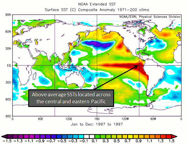
| The El Niño-Southern Oscillation (ENSO) is a naturally occurring phenomenon that involves fluctuating ocean temperatures in the equatorial Pacific. The warmer waters essentially slosh, or oscillate, back and forth across the Pacific, much like water in a bath tub. For North America and much of the globe, the phenomenon is known as a dominant force causing variations in regional climate patterns. The pattern generally fluctuates between two states: warmer than normal central and eastern equatorial Pacific SSTs (El Niño) and cooler than normal central and eastern equatorial Pacific SSTs (La Niña). Often, sea surface temperatures (SSTs) are used to identify this oscillation, but it is important to understand that changes in sub-surface ocean temperatures are the first to respond to an oncoming change in the ENSO phase. For instance, when ENSO is transitioning into a warm phase the sub-surface temperatures begin to warm above average, while a shallow layer of near average temperature remains at the surface. Eventually, the surface ocean temperatures will respond to the warming of the sub-surface temperatures, and a warm phase of the ENSO cycle ensues. The same cycle occurs, only opposite, for the cool phase of ENSO. When temperatures in the ENSO region of the Pacific are near average it is known as ENSO neutral, meaning that the oscillation is neither in a warm nor cool phase. Typically, atmospheric patterns during ENSO neutral are controlled more by other climate patterns (NAO, PNA) that vary on shorter timescales; these are examined on the following pages. |

Source: http://science.nasa.gov/ |
| El Niño (Warm Phase) The warm phase of the ENSO cycle features warmer than normal SSTs across the central and eastern equatorial Pacific along with:
|
 |
Typical El Niño Effects: December Through February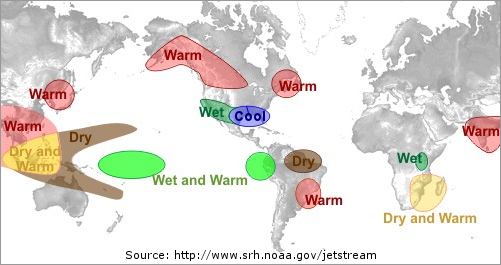 |
Typical El Niño Effects: June Through August |
Research conducted at the SCO indicates more storms and increased winter precipitation for the southeast during El Niño events. In contrast, decreased summer rainfall occurs during El Niño events, partly due to a decrease in the number of tropical cyclones that develop in the North Atlantic Basin.
| La Niña (Cool Phase) This phase of the ENSO cycle features cooler than normal SSTs across the central and eastern equatorial Pacific along with:
|
 |
Typical La Niña Effects: December Through February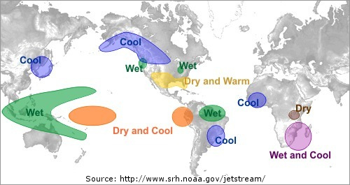 |
Typical La Niña Effects: June Through August |
Climatic conditions in North Carolina during La Niña conditions tend to be opposite those seen during El Niño events, including an increase in the number of tropical cyclones that develop in the North Atlantic Ocean.
The State Climate Office has also studied the relationship between severe weather, such as tornadoes, and El Niño / La Niña. In North Carolina, it appears that there are more tornadoes during La Niña events.
Current ENSO Conditions
http://www.cpc.noaa.gov/products/precip/CWlink/MJO/enso.shtml#current
Sources and Additional Information
http://www.cpc.noaa.gov/products/analysis_monitoring/impacts/warm_impacts.shtml


