

Coconut Island Lagoon, Oahu, Hawaii. Credit: Jenifer Rhoades
The Pacific Islands Ocean Observing System (PacIOOS) is the U.S. IOOS Region that covers the U.S. Pacific (Hawai‘i, Guam, American Samoa, Commonwealth of the Northern Mariana Islands), the Pacific nations in Free Association with the U.S. (Republic of the Marshall Islands, Federated States of Micronesia, Republic of Palau), and the U.S. Pacific Remote Island Areas (Howland, Baker, Johnston, Jarvis, Kingman, Palmyra, Midway, Wake). PacIOOS is a partnership of data providers and users working together to enhance ocean observations and develop, disseminate, evaluate and apply ocean data and information products designed to address the needs of stakeholders who call the Pacific Islands home.
Contact Information: Melissa Iwamoto, Director
About the Pacific Island Region
The PacIOOS region is the largest region within the IOOS system and covers a vast area of the globe — spanning six time zones across the Pacific Ocean; the region is bisected by the International Date Line, straddles all four hemispheres, is distributed over an area of nearly 35 million km , includes 2,500 km of coastlines, and over 2,300 individual islands. Though each of the island constituents in the PacIOOS region is distinct in terms of their respective governments, languages, legal systems, geographical setting, cultural norms, societal structure, economies, and level of infrastructure, all are uniquely tied to the ocean. The open and coastal waters of the region are a leading source of food, place of recreation, fuel for a tourism-based economy, network for transportation, and are a dominant driver of regional weather patterns and global climate
The Pacific Islands Ocean Observing System makes several products and tools available online.
- PacIOOS Voyager is a google map with overlays of various PacIOOS real-time data, sensor locations, model data, as well as other local meteorological and oceanographic information.

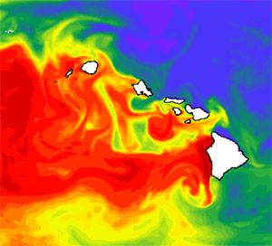
Ocean circulation and current forecasts are made daily using the Regional Ocean Modeling System (ROMS) for the Main Hawaiian Islands with increased resolution on Oahu.
- Real-time observations of wave conditions, surface currents, water quality, harbor surge, and sea level are provided.
- Other products for the Pacific Islands region include wave, ocean circulation and atmospheric forecasts; coastal inundation forecasts; sea level rise mapping tools; and tiger shark tracking.
Activities that PacIOOS undertakes are as follows:
- Outreach and Engagement: Addresses stakeholder needs to expand PacIOOS’ user base, facilitate informed decision-making, and guide the future development of PacIOOS.
- Water Quality: Monitor water quality in the Pacific to help partners protect ecosystem, wildlife, and human health.
- Marine Operations: Improve marine operations and decision making for industry and emergency responders with reliable ocean observations.
- Ecosystems and Living Marine Resources: Inform ecosystem based management with innovative technologies and efforts.
- Coastal Hazards: Assist coastal hazard planning, mitigation, and response by providing real-time and forecast ocean conditions.
- Data Management System: Evolve to be the lead source of ocean information, customized products, and decision-making tools for ocean stakeholders.
- Modeling: Expand geographical coverage of model forecasts to aid response and planning throughout the region.