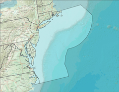
The Mid-Atlantic Coastal Ocean Observing System (MARACOOS) spans the coastal states from Cape Cod to Cape Hatteras. Coverage includes all of the estuaries and continental shelf waters within that coastal area.
Contact Information: Gerhard Kuska, Executive Director, kuska@maracoos.org
About the Mid-Atlantic Region
MARACOOS seeks to discover and apply new knowledge and understanding of our coastal ocean to help save lives and livelihoods, and maintain the quality of life in the Mid-Atlantic Region. To accomplish this, MARACOOS membership has identified five high-priority regional themes:
- Maritime Safety,
- Ecological Decision Support,
- Water Quality,
- Coastal Inundation, and
- Energy.
A fundamental MARACOOS asset is the diverse expertise of its approximately 1/3 academic, 1/3 industry, and 1/3 non-profit/government membership. MARACOOS has developed a collaborative network of scientific, business, non-profit and government leaders who are dedicated to applying their combined expertise to address priority regional needs. Multiple federal agencies have recognized the combination of expertise, operational capabilities, and opportunities in the Mid-Atlantic with their investments in this region including NOAA, Department of Defense, National Science Foundation, Department of Homeland Security (including USCG), NASA, and the Environmental Protection Agency.
To address its priority regional themes, MARACOOS has established a number of real-time observing and forecasting assets, including:
- An array of High-Frequency Surface Current Radars covering the entire MAB,
- A fleet of underwater gliders able to adaptively sample the entire MAB,
- A network of hardened meteorological stations distributed throughout the MAB,
- Three satellite ground stations acquiring imagery of the ocean, atmosphere and land,
- Coast Guard drifters used for SAR operations and to evaluate the skill of the forecasting systems, and
- An ensemble of both statistical and dynamical ocean forecast models that (a) assimilate spatial data from the satellites, the HF Radar network, and the fleet of autonomous ocean gliders, and (b) are forced by an ensemble of atmospheric models validated with the meteorological network.
The MARACOOS data and tools page features links to a number of data products. Information available includes:
- Web products such as real-time data and forecasts
- The MARACOOS Real-Time Data Assets map, with current observing data available through an interactive display
- Google Earth overlays that allow users to download kmz files for displaying data and model forecasts in Google Earth
- Weather forecasts and data from around the Mid-Atlantic Bight for both land and offshore regions
- Model outputs from four systems forecasting mid-Atlantic bight ocean circulation and a fifth model highlighting storm surge

