| Oyster Restoration Mapping Support |
|
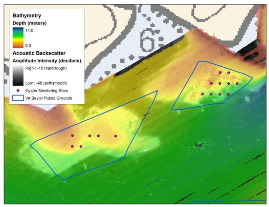
Native oyster restoration in the Chesapeake Bay focuses on creating hard surfaces (reefs) for larval oysters to settle on and planting hatchery-raised juvenile oysters (called spat) that are attached to oyster shells. Acoustic seabed surveying systems are used to identify oyster habitat and planting locations that will maximize the survival of spat-on-shell. Preferable restoration sites are hard, geologically stable terraces, of generally uniform depth, of moderate to high rugosity (a measure of surface irregularity), with sand or oyster shell as the base. Sites are typically located on historic oyster bottom. The NOAA Chesapeake Bay Office provides Maryland and Virginia oyster restoration partners with Geographic Information System (GIS)-ready acoustic mapping products that identify current distribution, structure and quality of oyster habitat. Composite image of backscatter and partially transparent bathymetry data collected by the NOAA Chesapeake Bay Office with historic oyster boundaries and recent monitoring sites in the Great Wicomico River, Virginia. In Maryland, NOAA has teamed wth the Maryland Geological Survey to provide the Oyster Recovery Partnership with mapping products and suggested boundaries for restoration sites. Boundaries are derived from side-scan sonar imagery, sub-bottom profiling, single beam seabed classification, and bathymetry data.
Side-scan sonar and seabed classification at Mill Hill Oyster Sanctuary in Eastern Bay, Maryland; Diver transects and spat-on-shell planting sites at Mill Hill sanctuary. Click images to enlarge. |