

Drought

USDA has the science-based solutions and technical experts on the ground today to help farmers and ranchers through drought and to prepare our country for weather events in the future. USDA offers technical and financial assistance to farmers and ranchers to cope with drought across the nation.
Every day, USDA is closely monitoring the drought and assisting farmers and ranchers with implementing voluntary conservation practices that help alleviate the drought's effects.

Latest USDA Drought Announcements:
- National Drought Resilience Partnership 2016 End of Year Report, January 2017
- National Drought Resilience Partnership - August 2016 Report
- June 23, 2016: USDA, Interior Announce More Than $47 Million in Investments for Water Conservation, Energy Efficiency, Drought Response & Agriculture Operations Across the West
- March 22, 2016: USDA Awards $8.5 Million to Improve Communities' Water Sources
- October 15, 2015 Fact Sheet: Impact of USDA Investments to Protect and Sustain America's Water Supply
- October 9, 2015: USDA Offers Assistance to Carolina Farmers and Ranchers Affected by Floods
- Jun 25, 2015: California-based Organizations Support Federal and State Investments to Support Water Quality and Quantity in Drought-Stricken California
- Jun 24, 2015: Agriculture Secretary Vilsack Announces $150 Million, New Partnership to Support Water Quality and Quantity in Drought-Stricken California
- 2015 White House Drought Factsheet
2016 Drought Disaster Updates
 Disaster Fast Track Map Updated 1/11/17
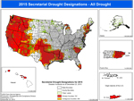
Drought Disaster Designations Map (PDF, 6MB)
Text-only (accessible) version
Map shows designations due to drought across the country under USDA's amended rule. Any county declared a primary (red) or contiguous (orange) disaster county makes producers in that county eligible for certain emergency aid.
List of Designated Drought Disaster Counties (PDF, 414KB)
U.S. Drought Monitor
 The U.S. Drought Monitor
 is a weekly map of drought conditions that is produced jointly by the National Oceanic and Atmospheric Administration, the U.S. Department of Agriculture, and the National Drought Mitigation Center (NDMC) at the University of Nebraska-Lincoln.
Drought Impact Reporter
 Submit a report to the Drought Impact Reporter
Please provide a description of how drought is affecting you, your livelihood, your activities, etc. The Drought Impact Reporter (DIR) is the nation's first comprehensive database of drought impacts. The DIR collects and displays reports, providing researchers and interested members of the public with context and detail of on the ground drought impacts across the nation.
Community Collaborative Rain, Hail & Snow Network
 Become a CoCoRaHS Observer
The CoCoRaHS network is a unique grassroots network of thousands of trained volunteers of all ages and backgrounds working together to improve meteorological science by measuring and reporting precipitation amounts (rain, hail, and snow). CoCoRaHS is the largest provider of daily precipitation observations in the United States. The data from these observations are used by USDA and the National Oceanic and Atmospheric Administration (NOAA) for tools such as the United States Drought Monitor.