
Maps
Google Maps and Google Earth Data
Google Maps and Earth shows you DEC's data in interactive maps with satellite imagery, photographs, local business information and driving directions. Google Earth allows map data to be viewed in a 3D virtual environment.
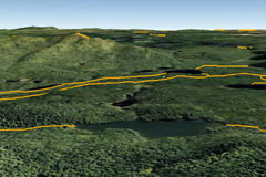
A Google Earth view of existing crosscountry
ski trails in a part of the Adirondacks.

A Google Maps view of DEC owned or operated
boat launch sites onto New York State waters.
Map Collection
The Map Collection contains non-interactive (static) maps that you may view, save or print.
You can find maps for:
- places to hunt;
- places to fish;
- places to go (recreational lands that you can visit);
- wildlife management areas;
- DEC campgrounds;
- and more.
Interactive Maps

The State Lands Interactive Mapper is an
excellent tool for hunters to use to view
the boundaries of wildlife management
areas in detail.
Each interactive map contains data on a certain topic or theme, including nature, environmental facilities, and minerals. You can use interactive tools to explore the data and create customized maps.
Some of DEC's interactive maps include:
- Wildlife Management Units (WMUs) - view boundary lines and local roads using DEC's State Land Interactive mapper and Google Earth.
- State Lands Interactive Mapper (SLIM) - discover recreational features such as roads, trails, and parking lots on DEC owned lands.
- New York Nature Explorer - find out about the animals, plants and habitats in your area of interest.
- Mineral Resources Navigator - locate mines and oil, gas and other regulated well types.
Go to DEC's interactive maps page for additional online maps.
Geodata Inventory
DEC's Geodata Inventory can be browsed at the NYS GIS Clearinghouse. The metadata for each dataset provides descriptive information about how, when and by whom a specific set of data was collected and how the data is formatted and accessed. Some data sets are available for download as shapefiles, and some can be downloaded and viewed in products like Google Earth.
