

You are here
Intermountain West Drought Early Warning System
Conditions for the week of Jan. 4-10
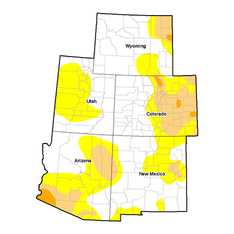
Decent snows (0.5-3 inches liquid equivalent) blanketed southeastern Wyoming, central Colorado, and central Utah, increasing the Water Year To Date (WYTD) basin average precipitation and snow water content to above normal , resulting in a one-category improvement. Some reservoirs were still below normal in these areas, but the decent snow pack should greatly contribute to a good spring snow melt runoff and recharge if conditions are maintained. In the Southwest, although precipitation was generally light (0.2-1 inch) or zero (in southern Arizona, and southern New Mexico), wet weather the previous two weeks with some improvements warranted status quo this week. Southern New Mexico will need to be watched for D0 development as the Jan. 10 snow-water content is well below normal (15-49%) while the WYTD precipitation is near or above normal (92-116%).
Read more about the Intermountain West DEWS
U.S. Drought Monitor - Intermountain West DEWS
As of January 10, 2017
Author: David Miskus,NOAA/NWS/NCEP/CPC
| Week | None | D0-D4 | D1-D4 | D2-D4 | D3-D4 | D4 |
|---|---|---|---|---|---|---|
| Current 1/10/2017 | 55.79% | 44.21% | 15.19% | 1.39% | 0.00% | 0.00% |
| Last Week 1/03/2017 | 49.44% | 50.56% | 18.89% | 1.51% | 0.00% | 0.00% |
| Three Months Ago 10/11/2016 | 51.84% | 48.16% | 15.83% | 1.63% | 0.00% | 0.00% |
| Start of Calendar Year 1/03/2017 | 49.44% | 50.56% | 18.89% | 1.51% | 0.00% | 0.00% |
| One Year Ago 1/12/2016 | 57.60% | 42.40% | 11.72% | 3.41% | 0.00% | 0.00% |
Drought Intensities
- None: No Drought
- D0: Abnormally Dry
- D1: Moderate Drought
- D2: Severe Drought
- D3: Extreme Drought
- D4: Exceptional Drought

Download the following time series chart as an Image,
Download the following time series data as JSON,
Download the following time series data as XML

Showing Data will replace the time series below with a data table.
Download the following pie chart as an Image

Showing Data will replace the pie chart below with a data table.