Landsat Missions

Landsat Collection 1 Processing Status

As of January 17, 2017
Landsat 7 ETM+ (1999-2016)
  • U.S. Complete!
  • World scenes to process 1,966,301
  • World scenes completed 1,380,613 (70%)
  • Years completed 2006-2016
  • Year in progress 2005
Landsat 4-5 TM (1982-2012)
  • U.S. Complete!
  • World scenes to process 2,061,307
  • World scenes completed 1,376,655 (67%)
  • Years completed 1994-2012
  • Year in progress 1993
Landsat 8 OLI/TIRS
  • Begin processing January 2017
  • Data available February 2017

For further information visit the Landsat Collections webpage.

Landsat represents the world's longest continuously acquired collection of space-based moderate-resolution land remote sensing data.

Four decades of imagery provides a unique resource for those who work in agriculture, geology, forestry, regional planning, education, mapping, and global change research.

Landsat Headlines

January 09, 2017

January 9, 2017 – Landsat Science Team: 2016 Summer Meeting Summary

The Landsat Science Team held their biannual meeting in July, 2016, at South Dakota State University in Brookings, South Dakota. A summary of this meeting was recently published by NASA in The Earth Observer (Volume 28, Issue 6). (Read More)

December 07, 2016

December 5-9, 2016 - Landsat Ground Station Operators Meeting

The 45th Landsat Ground Station Operators Working Group Meeting is being held December 5-9 in Libreville, Gabon. Members from USGS EROS, International Cooperators, and various partners will discuss topics related to Landsat Missions. (Read More)

December 02, 2016

December 2, 2016 - Landsat 9 Ground System Review

On November 30 – December 1, USGS EROS hosted the Landsat 9 Ground System Requirements Review (GSRR) in Sioux Falls, SD. This was the first in a series of major project reviews for Landsat 9, which is scheduled for launch December 2020. (Read More)

October 21, 2016

October 21, 2016 - Landsat 8 Collection 1 Sample Data

Landsat 8 Collection 1 Level-1 sample data are available. Users are encouraged to analyze these samples and contact User Services with any questions or feedback.

October 18, 2016

October 18, 2016 - Upcoming Website Interruptions

Access to this site may become interrupted between 6:00 pm to 9:00 pm CT on Thursday, October 20, 2016 due to system upgrades.

October 11, 2016

October 11, 2016 – Earth Observation Day

Landsat satellites have been imaging our planet since 1972, producing data that are valuable for land surface change detection, agricultural yield forecasting, disaster monitoring, and many other applications. As part of Earth Science Week, Earth Observation Day strives to (Read More)

September 30, 2016

September 30, 2016 - Landsat Science Team Leader Named Pecora Award Recipient

Dr. Curtis Woodcock of Boston University received the 2016 William T. Pecora Award for achievement in Earth remote sensing recently during a special event held in Washington, D.C. (Read More)

September 27, 2016

September 27, 2016 - Landsat Collection 1 Data Available

Landsat Collection 1 data are now available on EarthExplorer. Collection 1 data contain notable improvements from Pre-Collection data. The Landsat Collections webpage details these changes (Read More)

September 21, 2016

September 21, 2016 - 50 years of Landsat Vision

Today we celebrate the 50th anniversary of Secretary of the Interior Stewart Udall’s 1966 announcement of "Project EROS (Earth Resources Observation Satellites)”. Udall’s vision paved the way for what we today know as Landsat, and gave the world the confidence to create satellite (Read More)

September 02, 2016

September 1, 2016 - Landsat 9 Passes Mission Milestone

Landsat 9 passed one of its important reviews: “Key Decision Point B (KDP-B)” on August 17, 2016. KDP-B marks the entry of a NASA Flight Project into “Phase B”, during which a preliminary design for all mission segments is completed. (Read More)

Land Remote Sensing Image Collections

Wildfires Scorch Pampas Region of Argentina
Since mid-December 2016, roughly two dozen wildfires in the Pampas region of Argentina have consumed almost 2.5 million acres while unleashing giant plumes of dense smoke above the rural landscapes.
Marree Man Geoglyph in Australia Does Reappearing Act
In June 1998, a pilot discovered a strange sight in the Australian outback that wasn’t there before—a huge outline of what appeared to be an Aboriginal man throwing either a boomerang or a stick.
Rare Snow Falls at the Edge of Sahara Desert
In mid-December 2016, a rarity occurred on the edge of the Sahara Desert in northwest Africa. It snowed.
Expansion at the Port of Rotterdam
A large infrastructure project has changed the shape of the coastline of the Netherlands while increasing the cargo capacity at Europe's largest port.
A Landsat Mosaic for Indiana's Bicentennial
Throughout 2016, Indiana has been celebrating its 200th anniversary of statehood.
As Glaciers Worldwide Are Retreating, One Defies the Trend
Many glaciers around the world are losing ice mass and retreating.
Landsat Chronicles Deforestation in Colombia
Deforestation has long been a fact of life in the Amazon, Andean, and Caribbean regions of Colombia, South America, something that Landsat satellite data have thoroughly chronicled through the years.
Saudi Wheat Experiment Relied on Fossil Water
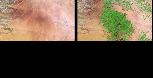
In the mid-1980s, Saudi Arabia embarked on an ambitious agricultural plan to grow crops in its desert areas using ancient fossil water deep beneath the sand, and installed center-pivot irrigation systems in the barren Wadi As-Sirhan basin in the northwest part of the country.
Three Gorges Dam Brings Power, Concerns to Central China
The construction of the Three Gorges Dam on the Yangtze River in central China offers an interesting glimpse into the balancing act borne from humanity's changing of the natural landscape.
Salar de Uyuni
When the huge prehistoric salt lake Lago Minchin, which used to cover all of southern Bolivia, began to dry up, it left several small lakes behind
Wildfires Scorch Pampas Region of Argentina Marree Man Geoglyph in Australia Does Reappearing Act Rare Snow Falls at the Edge of Sahara Desert Expansion at the Port of Rotterdam A Landsat Mosaic for Indiana As Glaciers Worldwide Are Retreating, One Defies the Trend Landsat Chronicles Deforestation in Colombia Saudi Wheat Experiment Relied on Fossil Water Three Gorges Dam Brings Power, Concerns to Central China Salar de Uyuni

Landsat Twitter

No front page content has been created yet.

“From a valuation standpoint, Landsat is an extremely valuable public good just in its direct use—let alone the economic value of all the indirect uses built on the direct data.”

John Loomis, an economist at Colorado State University, Landsat Benefited U.S. Economy by $1.8 Billion in 2011, Aug 30, 2015

“The Landsat archive holds great potential for studying the processes behind the Greenland Ice Sheet’s response to our changing climate over multi-decadal time scales. It is essential that this record be exploited over other areas of the Greenland Ice Sheet.”

Noel Gourmelen, Despite Warming, Landsat Reveals Decadal Slowdowns on Greenland Ice Sheet, Oct 28, 2015

"We are now beginning to see that the combination of high performance computing, data storage facilities, data preparation techniques, and advanced systems can materially accelerate the value of Landsat data."

Dr. Suzette Kimball, acting Director of the USGS, A New Era of Space Collaboration between Australia and U.S., Jun 18, 2015

“...the time is now right and urgent to apply space technology towards the solution of many pressing natural resources problems being compounded by population and industrial growth.”

Stewart L. Udall, Secretary of the Interior (1966)

“The economic value of just one year of Landsat data far exceeds the multi-year total cost of building, launching, and managing Landsat satellites and sensors.”

Landsat Seen as Stunning Return on Public Investment, Jan 14, 2015, USGS press release

“The value of Landsat data is internationally recognized as indispensable to science, natural resource management, commerce, security, foreign policy, agriculture, and education.”

National Geospatial Advisory Committee, Landsat Advisory Group, Statement on Landsat Data Use and Charges, Sept 18, 2012

About

Landsat represents the world's longest continuously acquired collection of space-based moderate-resolution land remote sensing data. Four decades of imagery provides a unique resource for those who work in agriculture, geology, forestry, regional planning, education, mapping, and global change research. Landsat images are also invaluable for emergency response and disaster relief.


Contact Us

Landsat Updates

The Landsat Update is an informal communication tool, prepared periodically and distributed electronically to USGS Landsat partners, to provide information about Landsat activities and related topics of interest.

Accessibility FOIA Privacy Policies and Notices

USA.gov logo U.S. Department of the Interior | U.S. Geological Survey
URL: https://landsat.usgs.gov
Page Contact Information: Ask Landsat
Page Last Modified: 11/29/16 03:03 pm
Sitemap