| GOES Composite | This large sector area shows infrared, visible, shortwave infrared and water vapor imagery and loops compositied from GOES East and GOES West. The following infrared enhancements are also available: AVN, Dvorak, JSL, RGB, Funktop, and Rainbow. This product is generated every 30 Minutes. Central U.S. Northern Hemisphere |
|
|
||
| GOES | Resolution: 10-20 Km | Frequency: 30 Minutes |
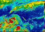
| GOES East Eastern U. S. |
This large sector area shows infrared, visible, shortwave infrared and water vapor imagery and loops from GOES East. The following infrared enhancements are also available: AVN, Dvorak, JSL, RGB, Funktop, and Rainbow. This product is generated every 30 Minutes. Product Link |
|
|
||
| GOES East | Resolution: 10 Km | Frequency: 30 Minutes |
| GOES East Regional Sectors |
Goes East provides static imagery and loops from the visible, infrared, shortwave and water vapor channels. This imagery is displayed with several enhancements including AVN, Dvorak, JSL, RGB, Funktop, and Rainbow. Regional Geostationary imagery is generated every 30 Minutes and is normally at 3-4 Km resolution. Regional Sectors (Overview) |
|
|
||
| GOES East | Resolution: 3-4 Km | Frequency: 30 Minutes |
| GOES East - NWS Weather Forecast Office (WFO) Sectors |
Infrared, visible, and shortwave infrared images and loops from GOES East are provided on the Weather Forecast Office (WFO) level. AVN, Dvorak, JSL, RGB, Funktop, and Rainbow enhancements are available along with multiple overlays on looping images. This product is generated every 15 minutes at 1-4 Km resolution. GOES-East imagery is not yet available for Western Region. We do plan to add all Western Region WFO sectors. GOES East - Weather Forecast Office (WFO) Regions |
|
|
||
| GOES East | Resolution: 1-4 Km | Frequency: 15 Minutes |
| GOES West Western U. S. |
This large sector area shows infrared, visible, shortwave infrared and water vapor imagery and loops from GOES West. The following infrared enhancements are also available: AVN, Dvorak, JSL, RGB, Funktop, and Rainbow. This product is generated every 30 Minutes. Product Link |
|
|
||
| GOES West | Resolution: 10 Km | Frequency: 30 Minutes |
| GOES West Regional Sectors |
Goes West provides static imagery and loops from the visible, infrared, shortwave and water vapor channels. This imagery is displayed with several enhancements including AVN, Dvorak, JSL, RGB, Funktop, and Rainbow. Regional Geostationary imagery is generated every 30 Minutes and is normally at 3-4 Km resolution. Regional Sectors (Overview) |
|
|
||
| GOES West | Resolution: 3-4 Km | Frequency: 30 Minutes |
| GOES West - NWS Weather Forecast Office (WFO) Sectors |
Infrared, visible, and shortwave infrared images and loops from GOES West are provided on the Weather Forecast Office (WFO) level. AVN, Dvorak, JSL, RGB, Funktop, and Rainbow enhancements are available along with multiple overlays on looping images. This product is generated every 15 minutes at 1-4 Km resolution. GOES-West imagery is only available for Western Region. We plan to add selected WFO sectors from Central and Southern Region within the GOES-West footprint. GOES West - WFO Regions |
|
|
||
| GOES West | Resolution: 1-4 Km | Frequency: 15 Minutes |
| MTSAT Sectors | Currently infrared, visible, and shortwave infrared images and loops from MTSAT for Palau, Yap, Marianas, Chuuk, Pohnpei/Kosrae, and the Marshall Islands are provided by the Geostationary Satellite Server. Overview Pacific Region (Guam and Micronesia) Northwest Pacific Imagery (Japan, Eastern China) West Pacific Imagery (Philippines, Southeast Asia) Southern Pacific Countries / Islands (Fiji, New Zealand, Vanuatu, etc) |
|
|
||
| MTSAT | Resolution: Varies | Frequency: Hourly |