


(Click for actual conditions)
Maps of hydrologic drought and streamflow in real time, daily, 7-day, 14-day, and 28-day levels as well as comparisons to historical streamflow.

(Click for actual conditions)
NASA scientists generate groundwater and soil moisture drought indicators each week, based on terrestrial water storage observations derived from satellite data and integrated with other observations.
(Click for more resources)
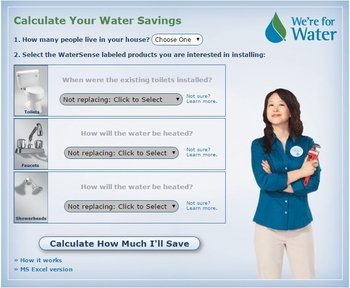
The U.S. Environmental Protection Agency offers a ways to use less water with water-efficient products, new homes, and services through tip sheets, product labeling, educational materials and more.

(Click for more resources)
List of publications and resources from the National Sustainable Agriculture Information Service. Topics range from drought-resistant soil to choosing water-use-efficient crops and more.

(Click for more resources)
The NRCS National Technology Support Centers staff a team of technical specialists in every aspect of freshwater quality and quantity. Direct access to professionals in many specific areas of concern is available.