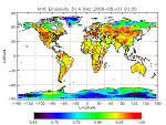
| Land Surface Emissivity (MSPPS) | The NESDIS operational Land Surface Emissivity (LSE) products are available from 23, 31 and 50.3 GHz channel measurements of the Advanced Microwave Sounding Units (AMSU) -A aboard on the NOAA POES satellites. The products are available at both pixel and grid levels
Product Link More information on MSPPS Products |
|
|
||
| POES | Resolution: 50 Km at nadir | Frequency: 12 hours |
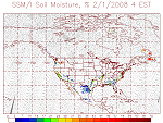
| Soil Moisture (SSM/I) | Product shows soil moisture for land regions. The soil moisture is derived from the passive microwave sensor SSM/I, which has 7 channels of 19 GHz (H, V), 22 GHz (V), 37 GHz (H, V), and 85 GHz (H, V), where H is the horizontal polarization, V is the vertical polarization. The soil moisture varies from 0 to 70 mm with accuracy of 1 mm. The product is updated once per day at 4 am EST.
This product is originally generated by Fleet Numerical Meteorology and Oceanography Center (FNMOC). NOAA/NESDIS gets the product through an interagency program referred to as the Shared Processing Program in which NOAA, the US Air Force and US Navy participate. OSDPD converts the product into HDF-EOS and WMO BUFR formats and distributed to users. Product Link |
|
|
||
| POES | Mapped Resolution: 25 km | Frequency: Daily |
| Surface & Insolation Products (GSIP-fd) | The full disk GOES Surface & Insolation Products (GSIP-fd) processing system is a near real-time operational system for generating products related to Earth radiation budget and associated products, which include radiative fluxes for the shortwave, longwave, and visible portions of the electromagnetic spectrum; surface temperature; and cloud properties. Radiative fluxes are calculated for downward and upward directions at the Earth surface and the top-of-atmosphere. The primary output products are the insolation (shortwave downward surface radiative flux) and photosynthetically available radiation or PAR (visible downward surface radiative flux), which are used in predictive models of coral reef health (coral bleaching prediction) and hydrological models (e.g., solar influence on evapotranspiration).
Product Link | Version 3 |
|
|
||
| GOES | Resolution: 1/8 Degree | Frequency: 1-3 Hours |
| Land Surface Temperature (GLST) | Land surface temperature, a key indicator of the Earth surface energy budget, is widely required in applications of hydrology, meteorology and climatology. It is of fundamental importance to the net radiation budget at the Earth's surface and for monitoring the state of crops and vegetation, as well as an important indicator of both the greenhouse effect and the energy flux between the atmosphere and earth surface. Land Surface Temperature (LST) from NOAA's Geostationary Operational Environmental Satellites (GOES) has been available as secondary products from other GOES product systems. In this product system, GOES LST is produced for the first time as primary products for operational use by NCEP/EMC for weather forecast and data assimilation models.
Product Link |
|
|
||
| GOES | Resolution: 1 km | Frequency: 1-3 Hours |
| Surface Temperature (DPI) | Product shows false color images of derived product imagery of the temperature of the uppermost layer of the land surface (degrees K). The DPI products are generated hourly with coverage over the CONUS and adjacent ocean areas.
GOES Sounder Single Image GOES Sounder Image Loop |
|
|
||
| GOES | Resolution: 4 km (Imager) / 10 km (Sounder) | Frequency: Hourly |
| Surface Temperature (MSPPS) | Land Surface Temperature (LST) is a key indicator of land surface states, and can provide information on surface-atmosphere heat and mass fluxes, vegetation water stress, and soil moisture. It is one of the key parameters in the physics of land surface processes, combining surface-atmosphere interactions and the energy fluxes between the atmosphere and the ground.
The NESDIS operational LST product is derived from 23, 31 and 50.3 GHz channel measurements of the Advanced Microwave Sounding Units (AMSU) -A aboard on the NOAA POES satellites, and is expressed here in Degree Kelvin. The products are available at both pixel and grid levels. Product Link More information on MSPPS Products |
|
|
||
| POES | Resolution: 45 Km at nadir | Frequency: 12 hours |
| Surface Temperature (SSM/I) | Product shows surface temperature over land. The land surface temperature is derived from the passive microwave sensor SSM/I, which has 7 channels of 19 GHz (H, V), 22 GHz (V), 37 GHz (H, V), and 85 GHz (H, V), where H is the horizontal polarization, V is the vertical polarization. The land surface temperature varies from -99 to 69 with accuracy of 1 Degree Kelvin. The product is updated once per day at 4 am EST.
This product is originally generated by Fleet Numerical Meteorology and Oceanography Center (FNMOC). NOAA/NESDIS gets the product through an interagency program referred to as the Shared Processing Program in which NOAA, the US Air Force and US Navy participate. OSDPD converts the product into HDF-EOS and WMO BUFR formats and distributed to users. Product Link |
|
|
||
| POES | Resolution: 25 km | Frequency: Daily |
| Surface Type(SSM/I) | Product shows surface type around the world. The surface type is defined with the surface tag values at a given latitude and longitude. The surface types include: Floods; Dense Vegetation; Agricultural/Range Vegetation; Dry arable soil; Moist soil; Semi-Desert; Desert; Composite vegetation and water; Composite soil and water; Dry snow; Wet snow; Refrozen snow; Glacial ice. The product is updated once per day at 4 am EST.
This product is originally generated by Fleet Numerical Meteorology and Oceanography Center (FNMOC). NOAA/NESDIS gets the product through an interagency program referred to as the Shared Processing Program in which NOAA, the US Air Force and US Navy participate. OSDPD converts the product into HDF-EOS and WMO BUFR formats and distributed to users. Product Link |
|
|
||
| GOES or POES | Resolution: 25 km | Frequency: Daily |