| Snow Cover (MSPPS) | The AMSU snow cover product is a True/False (1/0) indicator of existing snow. It is identified by the scattering depression difference of ice particles between 23.8, 31.4 and 89 GHz channel brightness temperature measurements of the Advanced Microwave Sounding Units (AMSU) -A & -B aboard on the NOAA POES satellites. The products are available at both pixel and grid levels.
Product Link |
|
|
||
| POES (AMSU) | Resolution: 16 Km at Nadir | Frequency: Orbital (Granule) or Daily |
| Snow Depth (SSM/I) | Product shows snow depth over land. The snow depth is derived from the passive microwave sensor SSM/I, which has 7 channels of 19 GHz (H, V), 22 GHz (V), 37 GHz (H, V), and 85 GHz (H, V), where H is the horizontal polarization, V is the vertical polarization. The snow depth measures the depth of recently accumulated dry snow, which varies from 0 to 400 with accuracy of 1 mm. The product is updated once per day at 4 am EST.
This product is originally generated by Fleet Numerical Meteorology and Oceanography Center (FNMOC). NOAA/NESDIS gets the product through an interagency program referred to as the Shared Processing Program in which NOAA, the US Air Force and US Navy participate. OSDPD converts the product into HDF-EOS and WMO BUFR formats and distributed to users. Product Link |
|
|
||
| POES (DMSP) | Resolution: 25 km | Frequency: Daily |
| Snow and Ice Cover - NH 24-km (IMS) |
This National Ice Center product shows daily snow and ice cover for the Northern Hemisphere, Continental United States, Alaska, Afghanistan and Asia/Europe. It is derived from several data sources, including the POES AVHRR and AMSU, GOES/Imager, GMS, and Meteosat. This 24-km resolution analysis has a 1024 x 1024 grid. The National Ice Center (NIC), is comprised of personnel from NOAA, The United States Navy and The United States Coast Guard.
Product Link |
|
|
||
| GOES and POES | Resolution: 24 km | Frequency: Daily |
| Snow and Ice Cover - NH 4-km (Automated) |
Product shows the snow and ice cover on a daily basis for the Northern Hemisphere. It is derived from several data sources including the POES AVHRR and AMSU, GOES/Imager, GMS, and Meteosat. This 4-km resolution analysis has a 6144 x 6144 grid. The algorithm is fully automated.
Product Link |
|
|
||
| GOES and POES | Resolution: 4 km | Frequency: Daily |
| Snow and Ice Cover - SH 4-km (Automated) |
Product shows the snow and ice cover on a daily basis for the Southern Hemisphere. It is derived from several data sources including the POES AVHRR and AMSU, GOES/Imager, GMS, and Meteosat. This 4-km resolution analysis has a 6144 x 6144 grid. The algorithm is fully automated, with archive snow and ice maps available since January 2005.
Product Link |
|
|
||
| GOES and POES | Resolution: 4 km | Frequency: Daily |
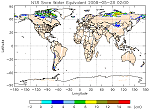
| Snow Water Equivalent (MSPPS) | Snow Water Equivalent (SWE) can be presented in units of kg/m2 or meters of depth of liquid water that would result from melting of the snow. It is derived from the brightness temperature difference between the lowest frequency channel (23.8 GHz) and higher frequency channel (31.4 GHz, 89 GHz) measurements of the Advanced Microwave Sounding Units (AMSU) -A & -B aboard on the NOAA POES satellites. The products are available at both pixel and grid levels.
Product Link More information on MSPPS Products |
|
|
||
| POES (AMSU) | Resolution: 16 km | Frequency: Orbital |
| Automated Snow Mapping System | The automated snow mapping system is based on a synergy of GOES-Imager, NOAA-AVHRR and DMSP-SSM/I data and produces daily snow cover maps for the North American continent.
Product Link |
|
|
||
| GOES and POES | Resolution: 1/25/Degree | Frequency: Daily |