
Photo by Bert Duet
Follow us 
USGS Southern Arizona Noon Seminar Series
DATA CENTER
Arizona Weather Radar
ABOUT THE Arizona WSC
USGS IN YOUR STATE
USGS Water Science Centers are located in each state.

|
Water Resources of Arizona
Welcome to the U.S. Geological Survey (USGS) Web page for the water resources of Arizona; this is your direct link to all kinds of water-resource information. Here you'll find information on Arizona's rivers and streams. You'll also find information about groundwater, water quality, and many other topics.
|
-
USGS Southern Arizona Noon Seminar Series
Time: 12:00pm to 1:00pm (unless noted otherwise)
Location: Room 253, Dennis Deconcini Environment and Natural Resources Building, University of Arizona
|
| Date |
Speaker |
Seminar Title |
| January 26, 2017 |
James Callegary
USGS Arizona Water Science Center
|
Post-Wildfire Potential for Carbon and Nitrogen Retention and Sequestration in the Southwestern United States in Restored Ephemeral and Intermittent Stream Channels (abstract) |
February 9
(TENTATIVE) |
Evan Canfield
|
Urban Runoff and Watershed Management |
-
 Click to view larger map image
Flood Warning Sites for the Community of Cedar Creek, Arizona
The Arizona Water Science Center installed a network of rain gages and stream gages in response to the Cedar Fire to provide flood warning for the community of Cedar Creek, Arizona.
Links to Cedar Fire Flood warning stream and precipitation stations
-
Grand Canyon High Flow Monitoring
Video: The USGS monitors sediment loads during Grand Canyon's beach-building high flow releases.
-
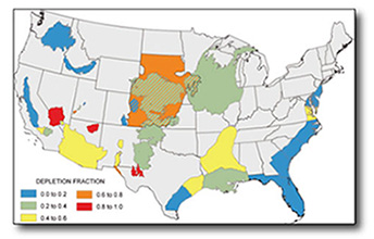 Estimated long-term cumulative storage depletion fraction in 31 areas and aquifers within the United States.
Depletion and Capture: Revisiting The Source of Water Derived from Wells
Lenny Konikow of the USGS National Research Program and Stan Leake of the Arizona Water Science Center have a new article entitled "Depletion and Capture: Revisiting The Source of Water Derived from Wells," published in a current issue of the journal Groundwater. Sources of water to pumped wells include storage depletion and capture of water entering or leaving aquifers. The authors discuss how depletion and capture are linked through time and how limited available capture can affect the sources of water to pumped wells. In the figure shown here, the authors indicate estimated ratios of storage depletion to volume of groundwater pumped for 31 areas and aquifers in the United States. The article can be accessed at http://onlinelibrary.wiley.com/doi/10.1111/gwat.12204/pdf
-
Maps of the damping factor at the
water table in Central Valley, California, computed by the screening tool.
Click to view larger image....
New tool for improving simulation of recharge in groundwater models
Recharge of aquifers by the infiltration of surface water varies over time, but at widely different rates. In some cases, groundwater models can treat recharge as a steady process (not varying over time), which makes the model simpler and more efficient to run. In other cases, variation in recharge over time is an important process, and should be included in a groundwater model to improve its accuracy. A new screening tool developed at the Arizona Water Science Center can simplify groundwater models by delineating areas where recharge can be treated as steady state. The screening tool determines a damping depth that is based on an analytical solution for the damping of sinusoidal infiltration variations in homogeneous soils in the vadose zone. Groundwater recharge may be considered steady where the damping depth is above the depth of the water table. A recent paper in Vadose Zone Journal presents nomograms for predicting the damping depth for clay and sandy soils. The screening tool was applied to Central Valley, California and found areas where monthly, seasonal, or annual variations in infiltration may be damped to steady rates. A MATLAB script, DAMP, is available for computing the damping factor for any soil and any sinusoidal flux variation. A discussion of the paper and its implications for groundwater modeling is a featured story by the Soil Science Society of America.
-

USGS Streamgaging in the 1920s
While the US Geological Survey (USGS) streamgage located at the Colorado River in Grand Canyon was not one of the first USGS streamgages established in Arizona, it was certainly one of the most remote and difficult-to-access gages. Located within the ancient Vishnu Schist in the inner gorge of Grand Canyon, the first permanent gage was constructed in 1922. One of the first gaging station operators at the site was Glenton Godfrey Sykes.
Read stories about streamgaging on the Colorado River in the 1920s as Glenton Sykes wrote them in his unpublished autobiography, Scraps From the Past.
|
Of Interest....

|

Real-Time Streamflow Data Portal
Access real-time streamflow data using an interactive map!
USGS WaterNow - Have current conditions for water data sent directly to your mobile phone or email.
Streamer - Explore America's larger streams as you trace upstream to their source or downstream to where they empty.

Explanation of percentile classes
|
Hydrologic Conditions

Arizona Groundwater Conditions Interactive Map
What is the current status of ground-water conditions in Arizona? How do conditions compare now versus before widespread development of groundwater? How far have water levels fallen, both in the past and recently? Have any wells shown rises in water levels, either in the past or recently? What are the recent trends in groundwater levels? Visit the Arizona Groundwater Conditions Interactive Map page to find out.
|
Drought Conditions for Selected Basins
The USGS, in cooperation with the Governor's Drought Task Force, has developed a series of maps showing drought intensity for selected drainage basins in Arizona. To view historical maps, learn how the maps are developed, and download images, visit our drought page.
|
Drought conditions for
September 2016

Click to view larger image
|
|
Recent Publications
 Scientific Investigations Report 2016-5115
Simulation of groundwater withdrawal scenarios for the Redwall-Muav and Coconino Aquifer Systems of northern and central Arizona
by D.R. Pool
|
 Open-File Report 2016–1155
Gravity change from 2014 to 2015, Sierra Vista Subwatershed, Upper San Pedro Basin, Arizona
by Jeffrey R. Kennedy
|
 Scientific Investigations Report 2016-5114
Hydrological conditions and evaluation of sustainable groundwater use in the Sierra Vista Subwatershed, Upper San Pedro Basin, southeastern Arizona
by Bruce Gungle, James B. Callegary, Nicholas V. Paretti, Jeffrey R. Kennedy, Christopher J. Eastoe, Dale S. Turner, Jesse E. Dickinson, Lainie R. Levick, and Zachary P. Sugg
|
 Bulletin of Environmental Contamination and Toxicology
Investigation of Total and Hexavalent Chromium in Filtered and Unfiltered Groundwater Samples at the Tucson International Airport Superfund Site
by Fred Tillman, R. Blaine McCleskey, and Edythi Hermosillo
|
 Geophysical Research Letters
Changes in groundwater recharge under projected climate in the upper Colorado River basin
by Fred Tillman, Subhrendu Gangopadhyay, and Tom Pruitt
|
 Open-File Report 2016–1088
Hydrologic analyses in support of the Navajo Generating Station–Kayenta Mine Complex environmental impact statement
by Stanley A. Leake, Jamie P. Macy, and Margot Truini
|
 Open-File Report 2016-1053
Analysis of stable isotope ratios (δ18O and δ2H) in precipitation of the Verde River watershed, Arizona 2013 through 2014
by Kimberly R. Beisner, Nicholas V. Paretti, and Rachel S. Tucci
|
 Journal Of The American Water Resources Association
Supporting Diverse Data Providers in the Open Water Data Initiative: Communicating Water Data Quality and Fitness of Use
by Sara Larsen, Stuart Hamilton, Jessica Lucido, Bradley Garner, and Dwane Young,
|
 Journal of Arid Environments
A comparison of estimates of basin-scale soil-moisture evapotranspiration and estimates of riparian groundwater evapotranspiration with implications for water budgets in the Verde Valley, Central Arizona, USA
by F.D. Tillmann, S.M. Wiele, and D.R. Pool
|
 Geophysical Journal International
Accounting for time- and space-varying changes in the gravity field to improve the network adjustment of relative-gravity data
by Jeffrey R. Kennedy and Ty P.A. Ferré
|
|
|


