NSSL Projects
Featured Projects

FACETs: Forecasting a Continuum of Environmental Threats
FACETs is a proposed next-generation severe weather watch and warning framework that is modern, flexible, and designed to communicate clear and simple hazardous weather information to serve the public. FACETs supports NOAA's Weather-Ready Nation initiative to build community resilience in the face of increasing vulnerability to extreme weather and water events.

Warn-on-Forecast (WoF)
Collaborators on the Warn-on-Forecast project investigate ways to make predictions of severe weather so specific, forecasters will be able to issue a warning based on that forecast before the weather forms—up to an hour or more in advance.

mPING
The Hydrometeor Classification Algorithm (HCA) is continuously being refined using observations collected through NSSL's Meteorological Phenomena Identification Near the Ground (mPING) project. mPING is a project to collect weather information from the public through their smart phone or mobile device. Researchers compare the reports of precipitation with what is detected by the dual-polarized radar data.

Hazardous Weather Testbed (HWT)
NOAA's Hazardous Weather Testbed (HWT) is jointly managed by NSSL, the Storm Prediction Center (SPC), and the National Weather Service Oklahoma City/Norman Weather Forecast Office (OUN). The HWT accelerates the transition of promising new meteorological insights and technologies into advances in forecasting and warning for hazardous weather events throughout the United States.
Multi-Radar Multi-Sensor (MRMS)
The MRMS system produces severe weather and precipitation products for improved decision-making capability within NOAA. The automated algorithms in MRMS quickly and intelligently integrate data streams from multiple radars, surface and upper air observations, lightning detection systems, satellite and forecast models.

Multifunction Phased Array Radar (MPAR) project
The Multi-function Phased Array Radar (MPAR) project was established to demonstrate the potential to simultaneously perform aircraft tracking, wind profiling, and weather surveillance with a single phased array weather radar. NOAA's National Weather Radar Testbed (NWRT) is a phased array radar (PAR) actively being tested and evaluated in Norman, Oklahoma.

FLASH
The Flooded Locations And Simulated Hydrographs Project (FLASH) was launched in early 2012 to improve the accuracy and timing of flash flood warnings. FLASH uses forecast models, geographic information, and real-time high-resolution, accurate rainfall observations from the NMQ/Q2 project to produce flash flood forecasts at 1-km/5-min resolution. FLASH project development continues to be an active collaboration between members of NSSL's Stormscale Hydrometeorology and Hydromodeling Groups, and the HyDROS Lab at the University of Oklahoma.

Field Projects
Field research gives NSSL scientists a way to test new technology, check their theories, and propose new ideas about severe weather. NSSL researchers often go into the field to observe severe weather. They use radars mounted on trucks, cars with weather instruments on them, special cameras and vehicles for launching weather balloons to observe and record the atmosphere in and around storms.
More Projects

CI-FLOW
The Coastal and Inland Flooding Observation and Warning (CI-FLOW) project is a demonstration projection that predicts the combined effects of coastal and inland floods for coastal North Carolina. CI-FLOW captures the complex interaction between rainfall, river flows, waves, and tides and storm surge, and how they will impact ocean and river water levels.
MPAR Software Upgrade Project
Specific goals for this project were to improve the quality of meteorological data produced by the NWRT PAR, to demonstrate adaptive scanning capabilities for weather observations, and to demonstrate dynamic scheduling of multi-function scanning strategies.
MYRORSS
The Multi-Year Reanalysis Of Remotely-Sensed Storms (MYRORSS) is a cooperative endeavor between the National Oceanic and Atmospheric Administration's (NOAA) National Severe Storms Laboratory (NSSL) and the National Climatic Data Center (NCDC) to reconstruct and evaluate numerical model output and radar products derived from 15 years of WSR-88D data over the coterminous U.S. (CONUS). The end result of this research will be a rich dataset with a diverse range of applications, including severe weather diagnosis and climatological information.

NSSL On-Demand
NSSL's On-Demand, a web-based tool helps confirm when and where severe weather occurred by mapping circulations or hail detected by radar on Google Earth satellite images. NWS forecasters can quickly review warnings and check their accuracy with this system.

PARISE
Each spring, NWS forecasters evaluate how rapidly updating phased array radar data impacts the warning decision-making process in the Phased Array Radar Innovative Sensing Experiment (PARISE).

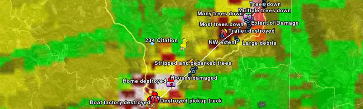
SHAVE
The Severe Hazards Analysis and Verification Experiment (SHAVE) project blended high-resolution radar data with reports of hail size, wind damage, flash flooding and winter weather collected through phone calls. The data helps evaluate the performance of radar technology and decision-making tools.

VORTEX-SE: Verification of the Origins of Rotation in Tornadoes EXperiment-Southeast
VORTEX-SE is a research program to understand how environmental factors characteristic of the southeastern United States affect the formation, intensity, structure, and path of tornadoes in this region. VORTEX-SE will also determine the best methods for communicating forecast uncertainty related to these events to the public, and evaluate public response. In many ways, VORTEX-SE represents a new approach to tornado research in general.

WDSS-II
The Warning Decision Support System: Integrated Information/National Mosaic and Multi-Sensor Quantitative Precipitation Estimation is the research version of MRMS. Successful applications will be moved into MRMS as they are approved.

NSSL Weather Research & Forecasting Model (WRF)
NSSL is working on ensemble forecast models for very short-range (0 to 60 minute) forecasts of severe weather events. Ensembles are groups of computer forecast models that are able to ingest Doppler radar, lightning or satellite data of thunderstorms to provide improved predictions of thunderstorms and their associated severe weather.
3DVAR
NWS forecasters are evaluating a new weather-adaptive 3DVAR system from NSSL/CIMMS that automatically detects and analyzes supercell thunderstorms. The 3DVAR system uses data from the national WSR-88D radar network and computer models to automatically locate regions of thunderstorm activity. It is able to identify deep rotating updrafts that indicate a supercell thunderstorm at 1 km resolution every five minutes in these regions. Initial development and testing of the 3DVAR was done at the Center for Analysis and Prediction of Storms at the University of Oklahoma.
Preliminary display of the 3DVAR product
NSSL Briefings: New system automatically detects supercell thunderstorms
FFaIR
A team from NSSL partners with the NOAA Hydrometeorological Testbed at the Weather Prediction Center in the Flash Flood and Intense Rainfall Experiment (FFaIR). FFaIR explores using high-resolution atmospheric and hydrologic models to improve short-term forecasts of both precipitation amounts and flash flooding.
Severe Weather Hazards Climatology
NSSL researchers watch trends over a number of years to look for patterns that could help improve severe weather forecasts and warnings.
ESTOFEX
NSSL supports the European Storm Forecast Experiment by evaluating the severe weather forecasts they produce for Europe. The project was started in 2002 and is ongoing.