Ocean Images
A gallery of great images of our ocean and coasts.
Latest Photos:
A regal slipper lobster (Arctides regalis) patrols a busy coral reef habitat of massive Porites and encrusting Monitpora corals off the coast of Moloka‘i in the main Hawaiian Islands.

Corals are home to millions of species. Humbug dascyllus (Dascyllus aruanus) and multibar goatfish (Parupeneus multifasciatus) are commonly seen in the shallow reefs and lagoons of American Samoa.

A sea anemone surrounded by Pocillopora, Porites, and giant clams at Kingman Reef in the Pacific Remote Islands Marine National Monument.

Close-up shot of a slate pencil urchin (Heterocentrotus mamillatus) at Kingman Reef in the Pacific Remote Islands Marine National Monument.

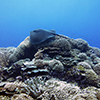
The coral reef benthic community at Swains Island in American Samoa is dominated by an assemblage of plating Montipora and branching Pocillopora meandrina.
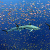
Grey reef sharks and colorful schools of anthias in the waters of Jarvis Island, Pacific Remote Island Areas Marine National Monument. Credit: Kelvin Gorospe

The Center for Operational Oceanographic Products and Services, in partnership with the Integrated Ocean Observing System (IOOS®), has established a new Physical Oceanographic Real Time System (PORTS®) in Cape Cod. A high tech wave-monitoring buoy was recently deployed in Cape Cod Bay that will provide ocean information to improve safety and efficiency of marine transportation as mariner’s approach or exit Cape Cod Canal. This buoy will also become part of the Northeastern Regional Association of Coastal Ocean Observing Systems buoy network. (Image courtesy of U.S. Geological Survey)

Students from Simon Sanchez High School view sedimentation in the Achang Marine Preserve after planting 1,000 acacia seedlings with the Guam Agriculture Department’s Forestry Division during an October 2015 restoration project in the Manell-Geus Habitat Focus Area. In the distance, a sediment plume is visible in the water after a storm.
The Manell-Geus watershed is a NOAA Habitat Blueprint site located in southern Guam. Habitat Blueprint is focused on improving habitat as a way to improve resilience to climate change impacts. From planting trees to stabilize soil to training people to monitor their coral reef resources, NOAA and Merizo residents are teaming up to support natural resource management to ensure strong fishing traditions and healthy reef habitats exist for years, and generations, to come.
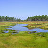
The Geus River in the Manell-Geus watershed Habitat Focus Area is an important cultural, recreational, and subsistence area for many local residents. The area includes the island’s only shallow water lagoon, as well as fringing reefs, mangroves and extensive seagrass beds. It is also home to the coastal village of Merizo, which is well-known for its strong fishing tradition.

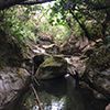
Priest Pools is a popular hiking spot for Merizo residents and visitors. It is located in the Manell-Geus watershed, a NOAA Habitat Blueprint site located in southern Guam. The area includes the island’s only shallow water lagoon, as well as fringing reefs, mangroves and extensive seagrass beds. It is also home to the coastal village of Merizo, which is well-known for its strong fishing tradition.

NOAA expanded its Physical Oceanographic Real-Time System (PORTS®) to Cleveland, Ohio, to aid navigation on the Cuyahoga River. The Cuyahoga River PORTS® current meter provides critical real time data that helps vessels safely transit iron ore upriver into Cleveland’s lakefront facilities.
A pink whipray (Himantura fai) glides over colonies of the branching coral Stylophora at Swains Island, American Samoa.
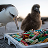
In May, the 2016 Northwestern Hawaiian Islands marine debris removal mission came to an end, successfully hauling in 12 tons of debris from Papahānaumokuākea Marine National Monument. A marine debris team of 10 NOAA scientists was part of the removal effort that spanned 32 days cleaning Midway Atoll National Wildlife Refuge, Pearl and Hermes Atoll, Kure Atoll State Wildlife Sanctuary, Lisianski Island, and the French Frigate Shoals. In this image, a Laysan Albatross looks curiously at a pile of disposable cigarette lighters. These were part of the 535 cigarette lighters collected during this year’s mission.

National marine sanctuaries and marine national monuments are places for great diversity of ocean life and this image doesn’t disappoint. Here Bluestripe snapper, Ta’ape, Threespot damselfish, and Oval Chromis damselfish are seen swimming around Lobe coral, Pohaku puna, and Table coral at French Frigate Shoals in the Papahānaumokuākea Marine National Monument. Credit: James Watt/NOAA
Children explore the Rachel Carson Reserve during a field trip with North Carolina National Estuarine Research Reserve staff. The North Carolina Reserve was established to preserve the fragile natural areas that make up the third largest estuarine system in the country and the variety of life found there. Credit: Emily Woodward
Close up of a crown-of-thorns starfish at Gardner Pinnacles in Papahānaumokuākea Marine National Monument

Close up of a Spanish Dancer nudibranch egg ribbon in Papahānaumokuākea Marine National Monument
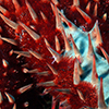
Close up of a sea urchin at the Pearl and Hermes Atoll in the Papahānaumokuākea Marine National Monument

An octopus camouflages itself in corals along the coast of Asuncion Island in the Commonwealth of the Northern Mariana Islands.

A juvenile threespot damselfish (Dendrogyra cylindrus) nestled in a pillar coral colony in St. Thomas, U.S. Virgin Islands. Pillar coral is listed as threatened under the Endangered Species Act.

A school of whitespotted surgeonfish (Acanthurus guttatus) pause their grazing for a moment before moving onto another suitable patch of reef in American Samoa.

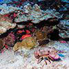
On the reef around the island of Ta‘ū, American Samoa, a spotted guard crab defends its home and food source, a cauliflower coral, from predators and investigative camera lenses.

Brown chromis (Chromis multilineata) and other small reef fish swim over large boulders of Great Star Coral (Montastraea cavernosa) in Flower Garden Banks National Marine Sanctuary. Various species of star coral and brain coral dominate the reefscape in the sanctuary.

In 1966, there was a major breakthrough in tide gauge technology with the introduction of the Analog-to-Digital (ADR) tide gauge. The ADR’s punch paper provided a computer compatible data recording, compared with earlier analog gauges which drew lines on a paper chart. The ADR paper tapes were read by an optical reader and translated onto nine-track magnetic tape for loading onto a computer system for processing. ADR gauges were used until 2003, when NOAA had fully transitioned to the Next Generation Water Level Measurement System.

In December 1866, the U.S. Coast Survey (NOAA's predecessor agency) began printing tide tables as an independent, annual publication. The first edition, for the year 1867, separated the predictions for the Atlantic coast and Pacific coast of the United States into two publications and gave only the daily high tides. Low tides were added in later years, as were tidal current predictions. In 2015, NOAA issued its 150th edition.

This image shows a female analyst operating the U.S. Coast and Geodetic Survey tide prediction machine No. 2 during World Word II. Today, tide predictions are computed electronically and distributed on NOAA’s tides and currents website.

The U.S. Coast and Geodetic Survey used tide prediction machine No. 2, fondly referred to as "Old Brass Brains," to predict tides from 1912-1965. It was the first machine made to simultaneously compute the height of the tide and the times of high and low waters. Today, tide predictions are made on electronic computers.
The Jacques Cousteau National Estuarine Research Reserve in New Jersey is regarded as one of the least disturbed estuaries in the densely populated urban corridor of the Northeastern United States. Credit: Jacques Cousteau National Estuarine Research Reserve.
Grand Bay National Estuarine Research Reserve is one of the most biologically diverse ecosystems in the northern Gulf of Mexico. Habitats for sea turtles, bottlenose dolphin, and manatees can be found in the deeper waters of this reserve. Oyster reefs and seagrass beds serve as nursery areas for important marine species such as shrimp, blue crab, speckled trout, and red fish. Credit: Gretchen L. Grammer.

Oyster beds at low tide. The North Carolina National Estuarine Research Reserve is comprised of four sites located near Corolla (Currituck Banks), Beaufort (Rachel Carson) and Wilmington (Masonboro Island and Zeke's Island) near Cape Hatteras. Credit: North Carolina National Estuarine Research Reserve.
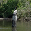
A brown pelican roosting atop a post in Weeks Bay National Estuarine Research Reserve in Alabama. Habitats in this reserve support numerous rare and endangered species including the eastern indigo snake and the Alabama red-bellied turtle. Credit: Weeks Bay National Estuarine Research Reserve.

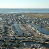
Pendleton Point in Islesboro, Maine. Did you know that Maine has more coastline than California? NOAA's official value for the total length of the U.S. shoreline is 95,471 miles. The NOAA shoreline length calculation was determined by hand in 1939-40 with a recording instrument on the largest-scale charts and maps available at that time. Shorelines of outer coast, offshore islands, sounds, bays, rivers, and creeks were included to the head of the tidewater or to a point where tidal waters narrow to a width of 100 feet. For the Great Lakes, the shoreline lengths were measured in 1970 by the International Coordinating Committee on Great Lakes Basic Hydraulic and Hydrologic Data.

Wells Beach, Maine. The economic benefits of tourism and coastal living contribute billions of dollars to the U.S. Economy. In 2011, the tourism and recreation industry in coastal shoreline counties employed almost three million people and contributed over $282 billion to the U.S. Gross Domestic Product (GDP).

Each year, the Center for the Study of Active Volcanoes at the University of Hawaii at Hilo holds an international training program to assist developing nations in monitoring technologies for potentially active volcanoes. This year, National Geodetic Survey's Francine Coloma shared her expertise in deploying and managing GPS equipment, networks, and related surveying techniques in this humanitarian outreach effort. The program is an international training course in volcano hazards monitoring sponsored by the U.S. Geological Survey's Volcano Disaster Assistance Program. This photo was shot at Holei Pali on the flank of Kilauea volcano on the Big Island of Hawaii.
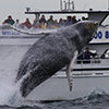
Stellwagen Bank National Marine Sanctuary is known as a world-class whale watching destination!

Kayaking is just one of the many recreational activities you may enjoy in our national marine sanctuaries. This image shows a kayaker in Monterey Bay National Marine Sanctuary.
Infographics
Wallpaper
Select Your Category


National Ocean Service | NOAA | Department of Commerce
Revised: 2016-09-21 | You are here: http://oceanservice.noaa.gov