Rathdrum Prairie Aquifer Hydrogeology
Hydrogeology is the study of water under the earth’s surface. If a geologic formation has significant quantities of water it is called an aquifer. An aquifer is defined as a formation that contains sufficient saturated, permeable material to yield significant quantities of water to wells and springs. The Rathdrum Prairie aquifer (RPA) is the primary source of drinking and irrigation water for everyone living on the Rathdrum Prairie.
Size of the Aquifer
The map below shows how far the Spokane Valley-Rathdrum Prairie (SVRP) aquifer extends laterally (north, south, east, and west), according to the U.S. Geological Survey (2005). The SVRP aquifer covers approximately 250 square miles in Idaho and 120 square miles in Washington. The RPA is that portion of the aquifer in Idaho. The lateral limits of the RPA are typically where the unconsolidated sediments (gravels, cobbles, and boulders) are next to a lake or contact the bedrock, or where a ground water divide is present. A ground water divide is an area underground in which the ground water flows in opposite directions, such as in the Spirit or Hoodoo Valleys.

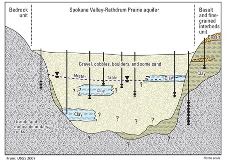
Subsurface information from water wells, a few seismic surveys, and a gravity survey give some indication how deep the RPA is. However, it is difficult to find wells over the RPA that have been drilled deep enough to hit bedrock (which would mean the bottom of the aquifer has been reached). Wells this deep are rare because the aquifer is very permeable, allowing most wells to pump enough water at a shallow depth. Below is an idealized cross section through the Spokane Valley-Rathdrum Prairie aquifer.
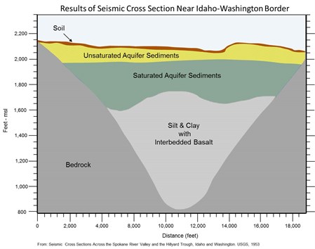
The first attempt to determine the thickness of the aquifer was completed by the USGS in 1953 (Newcomb & Others) through the completion of two seismic surveys across the aquifer. One was completed near the Idaho-Washington state line and the other near the Hillyard section of Spokane in Washington. The result of the seismic survey completed near the state line is shown below.
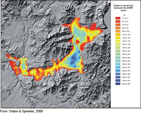
A gravity survey was also completed in 2006 (Oldow & Sprenke) to determine the thickness of the RPA. The gravity field at the earth's surface has extremely small variations, depending on the material below, and can be measured with an instrument called a gravimeter. The earth's gravity field is about equal to one g; a gravimeter is capable of measuring differences in the earth's gravity field of one one-hundred-thousandth (0.00001) of a g. A more dense subsurface material such as bedrock will result in a greater gravity measurement and less dense subsurface material such as unconsolidated deposits (gravel and cobbles) will result in a lower gravity measurement. At the edge of the aquifer, the unconsolidated deposits are thin and the bedrock is near the surface, which results in elevated gravity measurements. Toward the center of the RPA where the unconsolidated deposits are thick and the bedrock lies far below the surface, the gravity measurements are relatively low. Completing a number of gravity readings over the entire aquifer, one can map the depth to bedrock.
Existing gravity data for the Rathdrum Prairie were compiled, and gravity was measured at an additional 472 locations. The gravity data were then analyzed and processed to convert the gravity measurements into depth to bedrock. The depths to bedrock were plotted like topographic lines on a map and can be seen in the figure below. The depth to bedrock in the RPA varies between 0 and 420 meters (1,378 feet).
Composition of the Aquifer
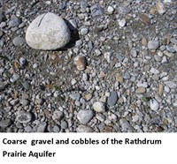
The RPA is made up of gravel, cobbles, and boulders with minor amounts of silt and sand. The aquifer’s ability to transmit water is based on the gradient of the water table (how steeply it is dipping) and some of the hydraulic properties of the aquifer. One of the more important properties is the hydraulic conductivity or sometimes called the permeability. The hydraulic conductivity is a measure of how easily water flows through a material. The different mixtures of gravel, cobbles, boulders, silt, and sand that compose the aquifer affect the ability of the aquifer to transmit water.
The hydraulic conductivity has units of length per time, such as feet per day (ft/d). Hydraulic conductivity is not a measure of how fast water moves in the aquifer, however. Typically, sand and gravel will have a hydraulic conductivity between 50 and 5,000 ft/d.
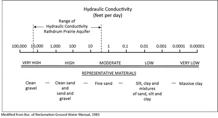
As the figure below shows, the hydraulic conductivity of material in the RPA can be very high — over 22,000 ft/d. This is due to the glacial floods that largely washed away fine material and left behind gravel, cobbles, and boulders which easily transmit water.

Aquifer Recharge
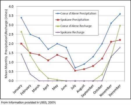
Water enters the RPA from various sources, including precipitation, runoff from the surrounding bedrock areas, seepage from lakes and rivers, and return flows from irrigation (irrigation water not used by plants that works its way back to the aquifer). Precipitation in the SVRP area occurs in the form of rain and snow. The yearly average precipitation for the Coeur d’Alene area is 25 inches and for the Spokane area is 16 inches. Approximately 70% of the precipitation falls between October and March of each year with about half of that as snow.

Water can be found on the earth's surface as lakes and rivers or on leaves and in puddles after it rains. Water that is heated by the sun or exposed to the wind evaporates and returns to the atmosphere as water vapor. Water can also return to the atmosphere through plants. Plants obtain water from the soil through their root systems. The water moves through the plant and exits through the plant’s leaves, in a process called transpiration. The transpired water also returns to the atmosphere as water vapor. This process of evaporation and transpiration is termed evapotranspiration. The amount of water that is subject to evapotranspiration is important because it will not be available to recharge the aquifer. In the SVRP aquifer, approximately 75% to 80% of precipitation is evapotranspirated and only 20% to 25% will recharge the aquifer.
There is growing concern about global climate change and the potential for air temperature to increase significantly over time. The Climate Impacts Group (CIG) located at the University of Washington used computer models to assess probable changes in the climate of the Inland Northwest. The computer modeling indicated three major changes: (1) winter snow pack will be lower than normal; (2) extreme high precipitation events will increase; and (3) temperatures are projected to increase across all season especially in the summer.
Water enters and leaves the aquifer in a number of different ways and in varying amounts. The figure below shows the total amounts flowing into and out of the SVRP aquifer in Idaho and Washington. Two of the largest contributors to the recharge of the aquifer in Idaho are seepage from the Spokane River and lakes along the aquifer boundary.

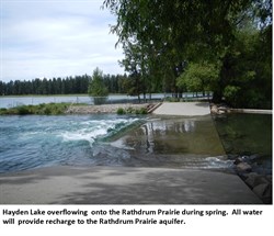 Some of the water that enters the RPA comes from surrounding upland areas called tributary basins. The precipitation that falls in these areas flows down to the aquifer as surface flow in streams and underground as ground water. The water recharges the aquifer by seeping into the ground around the edges of the aquifer. The adjacent photo shows the spring runoff from Hayden Lake. The elevation of the lake will rise to an elevation causing it to spill over and flood the fields to the west of the lake. All of the water will eventually recharge the Rathdrum Prairie aquifer.
Groundwater Flow
In the RPA, ground water flows from the north, near Spirit and Hoodoo Valleys and Lake Pend Oreille, southwards toward Post Falls. The aquifer is recharged along the way with runoff from the bedrock upland areas and the lateral lakes such as Hayden, Twin, and Spirit Lakes. Additional water flows westward from Coeur d'Alene Lake, eventually flowing toward the Idaho-Washington state line. Because of the very permeable nature of the aquifer, ground water flow velocities can reach approximately 50 feet per day.

The water levels in the aquifer can vary seasonally and over many years. Because the aquifer is so permeable changes in water levels are reflected throughout the entire area.

Water Use
The communities in Idaho and Washington use different amounts of water for different purposes. The chart below shows the types and quantities of water used in both Idaho and Washington. The larger population in Washington uses more water for municipal and domestic pumping, while the smaller population in Idaho uses less. Idaho uses more water for agricultural irrigation and Washington uses more water for industrial purposes.

One of the largest uses of water is for lawn irrigation. The chart below shows the difference in the quantity of water used during irrigation season and non-irrigation season for both Idaho and Washington. Use of water conservation methods could help reduce the amount of water used for irrigation.

Aquifer-River Interconnection
The Spokane River flows from Lake Coeur d’Alene in Idaho westward into Washington and eventually into Lake Spokane. The river in Idaho and portions of Washington is elevated above the aquifer and has water seeping out the bottom, which recharges the aquifer. These are referred to as “losing stretches” of the river. The elevation of the aquifer is slightly above the bottom of some portions of the Spokane River in Washington. Water seeps into the river from the aquifer and is referred to as “gaining stretches.”
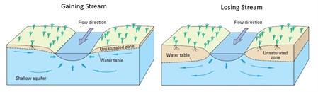 The permeable aquifer material allows relatively large interchanges of water with the river. The losing stretches of the Spokane River are the largest recharge source to the aquifer. The gaining sections obtain a significant amount of water from the aquifer. In Idaho, the Spokane River only loses water to the aquifer. In Washington, the river both loses and gains water from the aquifer. (See figure below.)

The reason the Spokane River both loses and gains water from the RPA in Washington is mainly due to the elevation change from Idaho to Washington. In Coeur d’Alene, the ground water is about 100 to 150 feet below the ground surface, but in Spokane, it varies from about 20 to 30 feet below ground surface to 0 feet at the Spokane River. The depth to ground water is much less in Washington because as you move west from Idaho to Washington, the ground surface elevation decreases much faster than the slope of the water table. Pumping from the aquifer can lower the amount of ground water that would have seeped into the river in the gaining stretches, which reduces the river flow. The closer a well is located to the gaining stretch or the greater the pump rate, the less ground water will be available to recharge the river.