|
 Based on lessons learned from the historic Mississippi River Flood of 2011, the U.S. Army Corps of Engineers, New Orleans District is releasing proposed clarifications to the standing instructions for operation of the Morganza Control Structure during a flood event. The Corps is releasing these proposed clarifications for a 30-day public review period and will host several public meetings to gather public input. Based on lessons learned from the historic Mississippi River Flood of 2011, the U.S. Army Corps of Engineers, New Orleans District is releasing proposed clarifications to the standing instructions for operation of the Morganza Control Structure during a flood event. The Corps is releasing these proposed clarifications for a 30-day public review period and will host several public meetings to gather public input.
The proposed clarifications to the standing instructions will help ensure safe operation of the Morganza Control Structure during a flood event and prevent unnecessary stress on mainline Mississippi River levees. As proposed, the Morganza Control Structure would be operated when a 10-day forecast projects a Mississippi River flow of 1.5 million cubic feet per second and rising past the structure. The structure would be operated to maintain a water stage of 57 feet on the river side of the structure and a Mississippi River discharge rate that does not exceed 1.5 million cubic feet per second below the floodway.
The U.S. Army Corps of Engineers learned important lessons from 2011 regarding the safe operation of the Mississippi River and Tributaries System and the Morganza Control Structure. The Corps’ goal for operation is to pass the project flood through the Mississippi River and Tributaries System safely, while reducing unnecessary stress on the flood control structures and the mainline MR&T levees. In the event that the Morganza Control Structure needs to be operated, the Corps will coordinate all emergency operation efforts with our federal, state and local partners before, during and after such events.
Please contact the New Orleans District, Public Affairs Office for more information at AskTheCorps@usace.army.mil or 504-862-1759. Hard copies of the proposed clarifications to the standing instructions can be mailed upon request.
Public meeting details are:
When: Tuesday, September 23, 2014
6:00 to 6:30 p.m. – Open House
6:30 to 8:30 p.m. – Presentation, Question and Answer Session
Where: St. Martinville
St. Martin Parish Government Building, 301 West Port St., St. Martinville, LA 70582
When: Tuesday, September 30, 2014
6:00 to 6:30 p.m. – Open House
6:30 to 8:30 p.m. – Presentation, Question and Answer Session
Where: Morgan City
Morgan City Auditorium, 728 Myrtle Street, Morgan City, LA 70380
When: Thursday, October 2, 2014
6:00 to 6:30 p.m. – Open House
6:30 to 8:30 p.m. – Presentation, Question and Answer Session
Where: Baton Rouge
Capitol Park Welcome Center, 702 River Rd., Baton Rouge, LA 70802
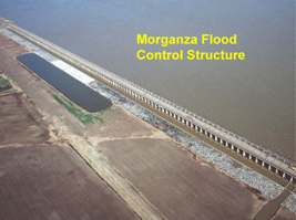 Intended to operate during emergency flooding, the purpose of the Morganza Floodway is to divert excess floodwater from the Mississippi River into the Atchafalaya Basin. The floodway consists of two structures – the Morganza Control Structure and the Morganza Floodway – which are designed to pass up to 600,000 cubic feet per second (cfs) of water to the Gulf of Mexico, alleviating stress for mainline levees downstream along the Mississippi River. Intended to operate during emergency flooding, the purpose of the Morganza Floodway is to divert excess floodwater from the Mississippi River into the Atchafalaya Basin. The floodway consists of two structures – the Morganza Control Structure and the Morganza Floodway – which are designed to pass up to 600,000 cubic feet per second (cfs) of water to the Gulf of Mexico, alleviating stress for mainline levees downstream along the Mississippi River.
Located at river mile 280 in central Louisiana, the Morganza Floodway begins at the Mississippi River, extends southward to the East Atchafalaya River levee, and eventually joins the Atchafalaya River Basin Floodway near Krotz Springs, Louisiana. Seven design plans were originally proposed, and a two-structure design was selected. Construction of both structures was completed in 1954. The first component at Morganza is the floodway. At twenty miles long and five miles wide, it consists of a stilling basin, an approach and outlet channel, and two guide levees. The second element is a control structure containing a concrete weir, two sluice gates, seventeen scour indicators, and 125 gated openings.
The decision to open the Morganza Floodway relies on current and projected river flows and levee conditions, river currents and  potential effects on navigation and revetments, extended rain and stage forecasts, and the duration of high river stages. When river flows at the Red River Landing are predicted to reach 1.5 million cfs and rising, the Corps considers opening the Morganza Floodway. potential effects on navigation and revetments, extended rain and stage forecasts, and the duration of high river stages. When river flows at the Red River Landing are predicted to reach 1.5 million cfs and rising, the Corps considers opening the Morganza Floodway.
Every year, written notices are issued to all interests reminding them of the possibility of operation of the floodway. In the event that Morganza needs to be opened, the USACE project managers, along with news media and civil officials, will help notify all interested parties as soon as possible. On receipt of such notice, expeditious action must be taken as soon as possible to protect life and property. If the Morganza Floodway is operated, there is a possibility that personal property will be flooded. In the event of an opening, all water and/or gas wells must be sealed and capped to prevent contamination from floodwaters.
The Morganza Floodway was partially operated during the 1973 high water event to relieve pressure on Old River’s Low Sill Structure. Overall, the spillway structure fared well with minor scouring and slight damage to the stilling basin. Repairs have since taken place and the structure has been restored to its original state. Inspections are ongoing to ensure that the structure operates correctly in the event of an opening
| Morganza Floodway Opening Pace: 2011 |
| |
2011 Date
|
Bays Opened
|
Total Opened 2011
|
Discharge (CFS)
|
| Day 1 |
May 14
|
2
|
2
|
21,000
|
| Day 2 |
May 15
|
7
|
9
|
96,000
|
| Day 3 |
May 16
|
6
|
15
|
158,000**
|
| Day 4 |
May 17
|
1
|
16
|
170,000
|
| Day 5 |
May 18
|
1
|
17
|
182,000
|
| Day 6 |
May 19
|
0
|
17
|
179,000
|
| Day 7 |
May 20
|
0
|
17
|
179,000
|
| Day 8 |
May 21
|
0
|
17
|
178,000
|
| Day 9 |
May 22
|
0
|
17
|
175,000
|
| Days 10 |
May 23
|
0
|
17
|
173,000
|
| Days 11 |
May 24
|
-1
|
16
|
160,000
|
| Days 12 |
May 25
|
-2
|
14
|
140,000
|
| Days 13 |
May 26
|
-2
|
12
|
121,000
|
| Days 14 |
May 27
|
0
|
12
|
120,000
|
| Days 15 |
May 28
|
0
|
12
|
119,000
|
| Days 16 |
May 29
|
-1
|
11
|
109,000
|
| Days 17 |
May 30
|
-1
|
10
|
98,000
|
| Days 18 |
May 31
|
0
|
10
|
97,000
|
| Days 19 |
Jun 1
|
-1
|
9
|
86,000
|
| Days 20 |
Jun 2
|
-1
|
8
|
76,000
|
| Days 21 |
Jun 3
|
-1
|
7
|
65,000
|
| Days 22 |
Jun 4
|
0
|
7
|
64,000
|
| Days 23 |
Jun 5
|
0
|
7
|
61,000
|
| Days 24 |
Jun 6
|
-2
|
5
|
41,000
|
| Days 25 |
Jun 7
|
-2
|
3
|
24,000
|
| Days 26 |
Jun 8
|
-1
|
2
|
15,400
|
| Days 27 |
Jun 9
|
-1
|
1
|
7,400
|
| Days 28 |
Jun 10
|
0
|
1
|
7,300
|
| Days 29 |
Jun 11
|
0
|
1
|
7,048
|
| Days 30 |
Jun 12
|
0
|
1
|
6,736
|
| Days 31 |
Jun 13
|
0
|
1
|
6,428
|
| Days 32 |
Jun 14
|
0
|
1
|
6,125
|
| Days 33 |
Jun 15
|
0
|
1
|
5,708
|
| Days 34 |
Jun 16
|
0
|
1
|
5,301
|
| Days 35 |
Jun 17
|
0
|
1
|
4,960
|
| Days 36 |
Jun 18
|
0
|
1
|
4,571
|
| Days 37 |
Jun 19
|
0
|
1
|
4,086
|
| Days 38 |
Jun 20
|
0
|
1
|
3,620
|
| Days 39 |
Jun 21
|
0
|
1
|
3,270
|
| Days 40 |
Jun 22
|
0
|
1
|
2,931
|
| Days 41 |
Jun 23
|
0
|
1
|
2,514
|
| Days 42 |
Jun 24
|
0
|
1
|
2,119
|
| Days 43 |
Jun 25
|
0
|
1
|
1,827
|
| Days 44 |
Jun 26
|
0
|
1
|
1,549
|
| Days 45 |
Jun 27
|
0
|
1
|
1,360
|
| Days 46 |
Jun 28
|
0
|
1
|
1,145
|
| Days 47 |
Jun 29
|
0
|
1
|
1,108
|
| Days 48 |
Jun 30
|
3
|
4
|
3,317
|
| Days 49 |
Jul 1
|
2
|
6
|
3,219
|
| Days 50 |
Jul 2
|
0
|
6
|
2,360
|
| Days 51 |
Jul 3
|
0
|
6
|
1,408
|
| Days 52 |
Jul 4
|
0
|
6
|
943
|
| Days 53 |
Jul 5
|
0
|
6
|
1,275*
|
| Days 54 |
Jul 6
|
0
|
6
|
1,015*
|
| Days 55 |
Jul 7
|
-6
|
0
|
720*
|
**Flow rate reduction - as more bays are opened, the capacity of each bay will decrease due to the elevation of the water in the receiving basin
*Sluice Gates Opened
NOTE: On Day 45 the structure lost hydraulic connection to the Mississippi River. After that the discharge was due to draining the forebay.
|