 Upper Ohio Navigation Final Feasibility/EIS Report
Chief's Report, Upper Ohio Navigation Study
Project Manager: Marc Glowczewski
Fact Sheet
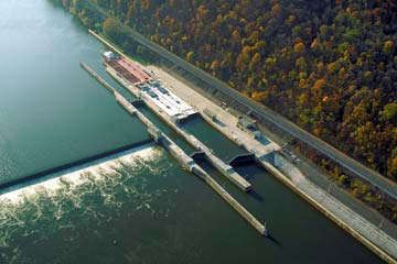
Profile of Old and New Ohio River Locks
The Upper Ohio Navigation Study recommends for Congressional authorization the National Economic Development (NED) plan for improving the upper Ohio River navigation system, specifically the Emsworth, Dashields and Montgomery Locks and Dams. Emsworth, Dashields and Montgomery, each constructed prior to 1936, are the first three locks and dams on the Ohio River just below Pittsburgh’s Point. These facilities have the oldest and smallest lock chambers in the entire Ohio River Navigation System. The study report recommends construction of one new lock chamber, sized 110’ x 600’, at each facility in the place of the existing auxiliary lock chambers. The total project cost for all three new chambers is $2.3 billion, which would be cost-shared jointly by the General Fund (50%) and the Inland Waterways Trust Fund (50%) (October 2014 Cost Level). The recommended plan’s incremental Benefit to Cost ratio is 4.3 to 1.
Authority
Authority was provided through a resolution adopted by the U.S. House of Representatives, Committee on Public Works and Transportation, adopted March 11, 1982, which reads as follows:
Resolved by the Committee on Public Works and Transportation of the House of Representatives, United States, that the Board of Engineers for Rivers and Harbors established by Section 3 of the River and Harbor Act, approved June 13, 1902, is hereby requested to review the reports on the Ohio River published as House Document No. 492, 60th Congress, First Session, and house Document No. 306, Seventy-fourth Congress, First Session, and other pertinent reports with a view to determine whether any modification in the authorized plan for modern barge navigation and other purposes on the Ohio River is advisable at this time with particular emphasis on the need for improvement or replacement of Emsworth Locks and Dams, Ohio River Mile 6.1; Dashields Locks and Dam, Ohio River Mile 13.3; Montgomery Island Locks and Dam, Ohio River Mile 31.7; and other locations where obsolete or inadequate facilities impede the orderly flow of commerce.
Capacity and Condition
Two major problems are associated with the upper Ohio River navigation system – structural condition and inadequate lock capacity for modern navigation tows. Emsworth, Dashields and Montgomery Locks and Dams have been in operation for 79, 71 and 64 years, respectively, and are nearing the end of their useful life. Built prior to air-entrained concrete, all three structures experience structural condition fatigue of the concrete causing unreliable structural capacity of the lock walls. Also, none of the structures meet modern design criteria.
Additionally, the lock chamber sizes (110’ x 600’ main chamber and 56’ x 360’ auxiliary chamber) are now well below the size required to accommodate the larger, more powerful modern tows that lock through the 110’ x 1200’ locks on the lower Ohio River. Many tows have to “double-lock” through the upper Ohio River locks’ main chambers, which consumes additional time and causes additional wear and tear on both the lock structure and operating machinery. These undersized lock chambers increase economic inefficiencies and, therefore, increase consumer costs. The economic justification for construction of larger locks will be evaluated in this feasibility study.
Major Rehabilitation
The Emsworth locks have been operational since 1922 while the original dams were rebuilt into gated structures and have been operational since 1938. Dashields and Montgomery Locks and Dams have been in operation since 1929 and 1936, respectively. The condition problems at these facilities were temporarily addressed during major rehabilitation projects at Emsworth, Dashields and Montgomery Locks and Dams undertaken in the 1980s and early 1990s. These efforts were only intended as stop-gap measures designed to extend the useful life of the structures for an additional 25 years. Given the affects of weathering and age on the projects, there were concerns over their continued reliability. Anchoring and other temporary solutions were implemented in an attempt to extend their life until more permanent repairs could be evaluated and implemented. Thus, the rehabilitation program was kept limited in scope and was guided by expediency in light of lock closure time constraints, costs or feasibility.
Many known problems were only corrected in part; others were left untouched because repairs were found to be non-feasible, and others similarly were left uncorrected because they were considered not critical. As an example, deteriorated concrete was left in place instead of being removed and was mostly covered over. Thus, while the surface appearance of the locks, particularly the top of the lock walls, appears in good condition, hidden below that surface are most of the problems that existed before the major rehabilitation efforts. It is further noted that the 25-year time period of the major rehabilitation for Emsworth, Dashields and Montgomery will end in 2010, 2015 and 2014, respectively.
Study Status
The District filed the Study’s Final Feasibility Report and Integrated Environmental Impact Statement (dated October 2014, revised May 2016) with the US Environmental Protection Agency in June 2016 and released the report at that time for state, agency, and public review. All comments received were addressed in an August 2016 revised final report, which then received a final Corps of Engineers policy review. Following these reviews, the Chief of Engineers signed and transmitted his Report of the Chief of Engineers with the Final Feasibility Report to Congress for authorization in the (currently pending) 2016 Water Resources Development Act.