Stephen Bunker: Sargassum Experiments, 21 October 2011

NOAA Teacher at Sea
Stephen Bunker
Aboard R/V Walton Smith
October 20 — 24, 2011

Mission: South Florida Bimonthly Regional Survey
Geographical Area: South Florida Coast and Gulf of Mexico
Date: 21 October 2011

Weather Data from the bridge

Time: 11:30 AM
Wind direction: Northeast
Wind velocity: 8 m/s
Air Temperature: 23° C (73° F)
Clouds: cirro cumulus

Science and Technology Log

Net Tow

That's me tending the Neuston net as it's being towed aside the R/V Walton Smith.

One of the many experiments we are doing on board is to learn about a plant that grows in the ocean called Sargassum. This tan plant floats near the surface and along in the current. It grows throughout the world’s topical seas. It can grow into large mats the and can be as large as boats and ships. Sargassum provides an environment for distinctive and plants and animals that are not found other places. These ecosystem rafts harbor many different organisms.

On the third stop of the CTD cycle we drag a Neuston net along side of the boat. For 1/2 hour, night or day, the boat takes a slow turn as we drag the net along the surface as we collect samples.  Almost all of the animals below are what we have found in the Neuston net.

We’ll haul in the net and remove the contents. We’ll first try to get all of the animals out. The animals usually don’t survive but every once in a while we can save them (see below for some of the animals we captured with the net).

We’ll next sort the plant life that we collect in the net. Of course we are looking for Sargassum, so we will separate out all of the sargassum.

So, how do you measure what you get? We measure it by volume much like our mom’s measure shortening for cookies. We will fill up a graduated cylinder part way with water, put the samples from the net into the cylinder and then measure how much water they displace.

For example, if we put 2500 ml of water in the graduated cylinder, then put Sargassum in the cylinder, the water level now measures 5500 ml . We then know that there are 3000 ml  (5500 ml – 2500 ml = 3000 ml) of Sargassum by volume measure.

Everything we collect from the net, we measure and record.

Personal Log — Animals I’ve seen

  • Flying Fish— Yes, believe it or not, there are fish that fly. Last night as were preparing to lower the CTD, I noticed silvery-blue streaks in the water. One of the scientists with me explained that they are Flying Fish (Exocoetidae) and the lights of our vessel attracts them and many other types of fish to the surface at night. As soon as she explained this, one of them shot out of the water and glided about a meter and ducked back into the water. Read more about Flying Fish here.
  • Rock Fish

    This fish was found as we unloaded the Moch net.

    Rock Fish — Each time we drag the Moch Net for the Sargassum survey, we can expect interesting things. Last night we captured a type of Rock Fish.

  • Spotted Eel — We also found an eel that has white spots. I tried my best to see if I could more specifically identify it. We have saved it in an aquarium on board the R/V Walton Smith.
  • Mystery Fish

    Help identify this mystery fish. Make a comment below if you think you know what it is.

    Mystery Fish — This fish has many of us stumped. It has a long nose but when the fish opens its mouth, you can see that the pointy part is connected to its lower jaw. Put your investigative skills to use and help me identify the fish. Post a comment if you think you know what it is. For an enlarged view, click here.

  • Moon Jellies — Many people call them Jelly Fish but actually they don’t belong to the fish family at all. They don’t even have a backbone. When we carefully picked these animals up, with gloves on of course, it feels like picking up Jello with your hands; it just slips through your fingers. You can find more about Moon Jellies, Aurelia aurita, at the Monterey Bay Aquarium. You can also find general information about Jellyfish at National Geographic Kids.
  • Sharptail eel

    This eel was found when we were collecting Sargassum.

    Sharptail eel — It’s about half a meter in length and squirms all over. The scientist studying the Sargassum, has saved it in an aquarium so we can observe it. Its scientific name is Myrichthys breviceps.

  • Honey Bee — Believe it or not a honey bee joined us. There was no land in view and a honey bee landed on me. The wind must have blown the bee to sea and it was probably very happy to find a place to land that was not wet.
  • Porpoise — We also call these dolphins. Sometimes a pod of porpoises will get curious and  investigate our boat. They will circle us, swim along side and even ride our bow wave.

Mark Silverman: Introduction: Prior to Fall Groundfish Survey Cruise, October 28, 2011

NOAA Teacher at Sea
Mark Silverman
Aboard NOAA Ship Oregon II
November 11 – 21, 2011

Hi.  My name is Mark Silverman and I will be sailing aboard the Oregon II beginning November 11, 2011. I  am a graduate of the University of Florida with a Bachelors of Science in Zoology.  I am an avid fisherman, snorkeler and SCUBA diver and a general outdoor enthusiast with a great love for the ocean and a fascination with all types of science.

Diving in the Kerama Islands off Okinawa Japan last summer.

I am currently teaching Chemistry at Homestead Senior High School, Homestead, FL.  Homestead Sr. serves about 2500 9-12 graders, a mix of urban and rural populations, at the the extreme southern tip of the Florida mainland.  I have been teaching since 1985, the last 16 years at Homestead Senior.

In my classroom.

South Florida is a unique environment in the U.S.  The climate is subtropical and many unique animals and plants are found here that are found nowhere else on the U.S. mainland.  We are surrounded by the waters of the Atlantic Ocean, Caribbean, Florida Bay, and the Gulf of Mexico.  Two national parks, Everglades National Park and Biscayne National Park, bound the east and west sides of Homestead.  Additionally, the northern terminus of the only living coral barrier reef adjacent to the U.S. mainland is found off our coast.  So, you can easily see why the ocean is so important to our way of life.  Ocean and climate literacy is extremely important in South Florida and as such I’m very excited to be participating soon in my second Teacher at Sea adventure!  Since I will be sailing during the school year this time, my students will be more even intimately involved than in the past.

That’s me “surfing” a whale shark this summer off of Tori in Okinawa, Japan!! ( I was not actually riding or injuring the animal in anyway…just a cool photo angle). Photo by: Chad Galvez

For those of you new to Teacher at Sea and Teacher at NOAA, I would like to share a little.  NOAA stands for National Oceanic and Atmospheric Administration.  NOAA is responsible for a wide variety of important functions, throughout the United States and the world, related to oceans, weather, and climate, including, but not limited to creating weather reports, tracking hurricanes, studying long-term climate, mapping the sea floor, creating nautical charts, studying fisheries with sustainable use as the goal, and managing MPA‘s (Marine Protected Areas).  NOAA Teacher at Sea is a program that promotes Ocean and Climate Literacy and NOAA career opportunities by allowing educators to participate in actual scientific research aboard research vessels and then bring back what they have experienced and learned to their classrooms.  I was a Teacher at Sea for the first time in the summer of 2006 aboard the NASA Ship MV FREEDOM STAR, where I assisted with a grouper and lionfish survey off the southeast coast of the United States (Yes, lionfish, a non-native species, but more about that later).

On the bridge of the NASA ship MV FREEDOM STAR in 2006.

After being involved with the development of NOAA Teacher in the Lab in 2007, I spent two summers, 2009 and 2010 at the Southeast Fisheries Science Center (SEFSC) on Virginia Key, Florida, as a pilot Teacher in the Lab.  There, I worked under the direction of Dr. Trika Gerard in the Early Life History Lab.  My work included identifying, counting, and sorting juvenile fish samples from Brewer’s Bay in the U.S. Virgin Islands.  The second summer I also extracted otoliths (ear bones…I will tell you more about otolith chemisty in the near future too) and prepared them for radioisotope analysis.  Subsequently the lab group hosted my students on several occasions during a fantastic field trip!  Working with Dr. Gerard, her lab manager Estrella Malca, and the many other professional scientists at SEFSC was a unique and wonderful experience which gave me a true insight into the work they do on a daily basis.  While I was there in 2010, the BP Gulf Oil spill crisis was going on.  Although this was a truly tragic event, watching these professionals mobilize in a crisis was an incredibly exciting and fascinating experience!

Snapper otolith after extraction and cleaning.

Extracting otoliths at NOAA SEFSC Juvenile and Larval Fishes lab in 2010.

Sorting and identifying fish samples at SEFSC in 2009.

I truly look forward to another great experience with NOAA TAS!!  I will be sailing out of Pascagoula, Mississippi aboard the NOAA ship Oregon II, a 170 foot trawler, set up as a fisheries research vessel.  I will be participating in a leg of the Fall Groundfish Survey.  This yearly survey monitors bottom fish in the Gulf of Mexico and is

The Fall Groundfish Survey area.

an important fisheries management tool. You can follow my journey and adventures in this blog and via the NOAA Ship Tracker.  Just click on the hyperlink, enter the ship tracker and select the Oregon II (R2) from the drop down menu on the right side of the screen.

The OREGON II.

I look forward to your virtual participation and comments!


Stephen Bunker: Science Experiments on the R/V Walton Smith, 20 October 2011

NOAA Teacher at Sea
Stephen Bunker
Aboard R/V Walton Smith
October 20 — 24, 2011

Mission: South Florida Bimonthly Regional Survey
Geographical Area: South Florida Coast and Gulf of Mexico
Date: 20 October 2011

Weather Data from the Bridge

Time: 11:39 AM
Wind direction: North-northwest
Wind velocity: 4.5 m/s
Air Temperature: 23 °C (75° F)
Clouds: Alto cumulus

Science and Technology Log

We left port today at about 6:30 AM, before the sun had even come up. We are  headed out to the Florida Keys. The rain has stopped as well as the wind. We left Miami Harbor as the sun was coming up.

Our scientific research will take place along the Florida Keys, a chain of low-lying  Islands that arc around the southern tip of Florida. The R/V Walton Smith will stop at predetermined stops and take measurements.

There are many science experiments happening on board. In each post, I will try to highlight a different experiment. I’ll start off with the CTD  because it is the experiment that drives our schedule throughout our cruise.

The Conductivity, Temperature, & Depth Instrument. Everyone on board calls it the CTD for short. The CTD schedule is our game plan. At about every 3 -5 hours — night and day —  we’ll cycle through a series 3-4 CTD drops.

Lower CDT

These are the instruments on the lower part of the CTD.

On the bottom of the CTD are a number of instruments that give real-time data to a scientist on board the boat. The conductivity part of the instrument measures how much electricity passes through the sea water. Using a mathematical algorithm that takes in account temperature and how much current passes through the water, we can determine the density (salinity) of the water.

Full CDT

The CTD on deck. The grey tubes fill with water.

The top part of the CTD has 12 cylinders that can trap water. Those are the grey tubes you see in the picture to the left. There are lids on the top and bottom of each tube that can be closed with a remote control from inside the boat. In this way the scientists can take water samples from any depth of water.

So, when we arrive at one of these predetermined location we’ll lower the CTD.

Once the CTD is just below the surface of the water and everything checks out, the scientist will radio to the crane operator to lower the CTD to within a meter of the bottom of the ocean. That can be anywhere from 5 meters to over 100 down. As the CTD lowers, the scientist monitors the CTD instrument real-time readouts. Using a graph of the data, he or she will decide at which locations to close the cylinders on its return trip to the surface.

CDT Control Center

Nelson monitors the CTD data as it is collected.

Water sample processing

Cheryl is processing water samples from the CTD.

Once it surfaces, we’ll  assist in placing the CTD back on the deck and securing it. We’ll then take water samples from the grey tubes. Those water samples will be analyzed in one of the laboratories on the boat. The water samples will show us chemical properties of the water.

Personal Log

Teamwork works! It takes a lot of teamwork to make things happen on board. Guiding the boat to the precise locations is the easy part for the crew. They have a GPS to help them do it. After they get there they have to maintain the location. That’s hard when currents, wind and waves, move the boat which is the size of a house. Then they delicately raise and lower the CTD.

Dave Diving

Crew member Dave preparing to dive in order to remove ropes caught in the ship propeller.

If something happens, they also need to fix it. They can’t drive it to a repair shop. They have to fix things on the spot. During the night, some ropes from lobster traps got tangled into one of the propellers. One of the crew put on scuba gear, got in the water, and removed the ropes.

The group of scientists have been organized into a day shift from 7:00 AM to 7:00 PM and the other half is on the night shift for 7:00 PM to 7:00 AM. This can be uncomfortable to have to stay awake all night, but it also means they have to sleep during the day. The day shift will also have a heavier work load because there are additional experiments that have to be done during the sunshine.

The bridge of the SV Walton Smith

Crew member Bill at the helm of the R/V Walton Smith

Cathrine Fox: Issue Sixteen: Lumpsucker (there is no more perfect title)

NOAA TEACHER AT SEA
CATHRINE PRENOT FOX
ONBOARD NOAA SHIP OSCAR DYSON
JULY 24 – AUGUST 14, 2011


Mission: Walleye Pollock Survey
Location: Kodiak, Alaska
Date: October 25, 2011

Personal Log:
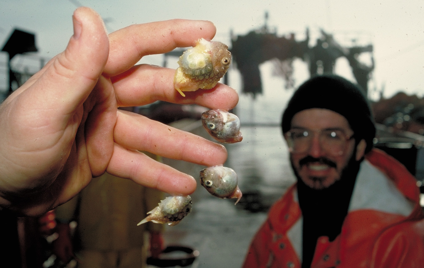
"It's not a party without a lumpsucker?"

“It’s not a party without a lumpsucker?”

What is the best birthday party you ever had? Let me set the stage for you to picture mine. It was a theme celebration: the guests came as a superhero or supermodel. Everyone was in costume. Balloons covered the floor. People brought so many flowers that I started putting them in washed out mayonnaise and pickle jars. The cake was homemade: I can’t now remember if it was chocolate oblivion or an upside-down fruit. I just remember that it was made from scratch. There were prizes for the best costumes. People danced for hours. I didn’t think that it could have ever gotten better. Until recently. Recently, I discovered lumpsuckers. For all of these years, I had no idea that my 29th could have gotten any better. Until now. Now I know that It’s not a party without a lumpsucker (Cartoon citations 1, 2 and 3).

Adventures in a Blue World, Issue 16

Adventures in a Blue World, Issue 16


Smooth and spiny lumpsuckers.

Smooth and spiny lumpsuckers.

I should explain why I chose a squishy dumpling with fins for the final cartoon of Adventures in a Blue World. It isn’t because my 29th birthday balloons should have been adorned by adorable fish (although admittedly they would have been grand). It is because, once again, I have found yet another inhabitant of our planet that I was ignorant of. As a biology teacher, I like to think that I have a fairly good handle on life, especially of our Animalia Kingdom. Who could have guessed, in their wildest dreams, that there were creatures like the lumpsucker that inhabit our oceans–our planet? With only 3% of the oceans explored, I can’t even fathom what else is out there. If we don’t explore, catalog and protect our oceans, we may never know.

I want to thank the Teacher at Sea Program of NOAA for an excellent and amazing adventure. In particular, the crew of the Oscar Dyson, the scientists of MACE, my fellow Teacher at Sea (rockstar) Staci DeSchryver and Elizabeth McMahon deserve special recognition. Thank you all so much.

Until our next adventure!
I wish you fair winds and following seas, a sailor’s farewell…

Cathrine Prenot Fox

Last evening: green flash watch.

Last evening: green flash watch.

Leaving Kodiak, AK.

Leaving Kodiak, AK.

Before I left I may have tagged some of the hard hats with cartoons...

Before I left I may have tagged some of the hard hats with cartoons…

Cathrine Fox: Issue Fifteen: So you want to be a scientist…

NOAA TEACHER AT SEA
CATHRINE PRENOT FOX
NOAA SHIP OSCAR DYSON
JULY 24 – AUGUST 14, 2011

Mission: Walleye Pollock Survey
Location: Kodiak, Alaska
Date: October 20, 2011

Personal Log:
Perhaps you are sitting at your desk right now, contemplating finishing work that you probably should be doing, or putting the last touches on a college application, or wondering if anyone brought any treats to share that are sitting in the lounge waiting your attention. Maybe it is late at night, and you are wishing that your work tomorrow was just a little more exciting.

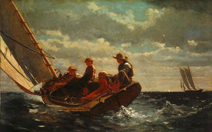
Winslow Homer, Breezing Up.  National Gallery of Art.

Winslow Homer, Breezing Up. National Gallery of Art.

What if your work tomorrow looked like this? Why not choose a life at sea instead? Think of this: thousands before you have gone off to sea… …and while it isn’t as romantic as it once was with pirate attacks and years away from home, it is now a lot more comfortable. Perhaps you have always dreamed of becoming a commanding officer of a ship, or a boatswain, or an engineer… How does one do it? How do you get to live, work, and learn through the National Oceanic and Atmospheric Administration? Look no further friends, I have just the right reading material to get you started: So you want to be a scientist? (Cartoon citations 1, 2 and 3).

Of particular interest to me (not surprisingly) are the opportunities for science research and exploration. I was captivated by Dr. Edith Widder’s research about bioluminscence, interested in the 2004 Titanic Expedition, and humbled by the wealth of knowledge presented in interviews with people from a variety of ocean careers.

Adventures in a Blue World, Issue 15

Adventures in a Blue World, Issue 15

Until our next adventure,
Cat

Kodiak Harbor

Kodiak Harbor

Measuring Walleye Pollock.

Measuring Walleye Pollock.

Dawn on the Dyson

Dawn on the Dyson

Bobble-heads on the Bridge.

Bobble-heads on the Bridge.

Insert your photo here: Life at Sea!

Insert your photo here: Life at Sea!

Stephen Bunker: Weather Delay, 17 October 2011

NOAA Teacher at Sea
Stephen Bunker
Aboard R/V Walton Smith
October 20 — 24, 2011

Mission: South Florida Bimonthly Regional Survey
Geographical Area: South Florida Coast and Gulf of Mexico
Date: 17 October 2011

Weather Data

For this blog entry I’ll give a brief report for weather. I’m still learning my way around the ship and and how to find where weather data is recorded.

It’s overcast with light rain.

Science and Technology Log

When I arrived at the RV Walton Smith I learned that our cruise would be delayed a couple of days because of weather. So I’m not out on the Ocean yet. In the Gulf of Mexico between Florida and the Yucatan Peninsula a combination of cold fronts and moist air are creating rain, rough seas, and wind that would make data gathering dangerous in the Florida Keys. Safety first is the motto.

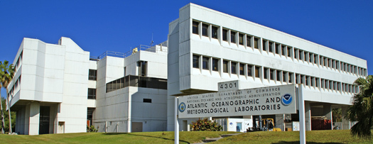
AOML Photo

NOAA's Atlantic Oceanographic & Meteorological Laboratory (AOML)

Coincidentally, just across the street from where the RV Walton Smith is docked is the Atlantic Oceanographic and Meteorological Laboratory (AOML). At the AOML this day meteorologists, scientists that study how the atmosphere and how it affects the earth and life on the earth, were interested in getting as much information as they can about this storm system. When the rest of us are taking cover from a storm, these scientists are out gathering data so they can better predict when and how storms act.

Both the meteorologists from AOML and our team of scientist were interested in this storm system for different reasons. They wanted to study the storm and we wanted to know if we could safely leave to do our scientific research. Our lead scientist for the cruise, Nelson Melo, invited me to attend a map discussion where the weather conditions were discussed. A map discussion is a meeting where scientists view, discuss, and decide what they can learn from a storm.

Map discussion at AOML

Map discussion at AOML

It was great to see that their satellite images of the storms were on the web were everyone can see them. Here is a sample of what they showed in the meeting.

Storm system over Gulf of Mexico

Animation of storm system over the Gulf of Mexico

NOAA 42

NOAA 42 Aircraft

This storm is headed toward Florida and has the possibility of growing into a tropical storm. In any case, we can plan for more rain, wind, and rough seas until it passes. The AOML scientists decided to request one of NOAA’s aircraft to observe the storm and we are going to stay put until the storm passes.

Personal Log

The soonest we could leave would be Thursday. The crew of the RV Walton keeps busy maintaining and keeping the vessel in top shape for when we do leave. I don’t feel much rocking while the boat is in dock.
Jacquelyn Hams: Introduction 17 October 2011

NOAA Teacher at Sea
Jackie Hams
Aboard R/V Roger Revelle
November 6 — December 10, 2011

My name is Jacquelyn (Jackie) Hams and I  am an Associate Professor and Chair of the Earth Science Department at Los Angeles Valley College (LAVC).  LAVC is a two-year college within the Los Angeles Community College District which consists of 9 major campuses, several satellite locations, and over 120,000 students.

Photograph of TAS Jackie Hams

Teacher at Sea Jackie Hams with the St. Croix River in the background.

This photograph was taken in October 2011 during the Geological Society of America Annual Meeting in Minneapolis, MN.  The St. Croix River which flows between Minnesota and Wisconsin is in the background.  In just a few weeks my background photos will look significantly different as I embark on my NOAA Teacher at Sea experience in the Indian Ocean.

I am participating in an investigation of ocean-atmosphere interactions in the equatorial Indian Ocean involving meteorologists, oceanographers, and climate scientists from 13 countries called Project DYNAMO (Dynamics of the Madden-Julian Oscillation).   The Madden-Julian Oscillation (MJO) is a 30-90 day tropical weather cycle that starts over the equatorial Indian Ocean and moves eastward into the western Pacific Ocean where it impacts other  global weather and climate patterns such as El Nino-Southern Oscillation (ENSO),  Asian monsoons,  tropical storm development in the Pacific and Atlantic oceans, and Pineapple Express events.  Specialized instruments will be deployed and operated on ships, aircraft, and islands in the Southern Indian Ocean, Maldives Islands, Diego Garcia British Indian Ocean Territory, and the Eastern Indian Ocean to collect data and study the MJO at its source.

 I am a Teacher at Sea on Leg 3 of a research cruise aboard the R/V Roger Revelle in the eastern Indian Ocean which is scheduled from November 6 – December 10 beginning and ending in Phuket, Thailand.  My students are not just following my adventures via this blog – I will be teaching the last 5 weeks of my Oceanography and Physical Geology classes from the ship.  This Teacher at Sea experience is also about learning in real-time and will be a true test of Distance Education!
Photograph of the Research Vessel Roger Revelle

R/V Roger Revelle. Image credit: Scripps Institution of Oceanography

Here are some great general Project DYNAMO links to bookmark and follow Leg 3 of the cruise.

  • DYNAMO Home Page.  Select the DYNAMO Field Catalog menu on the left, then the Reports menu at the top of the page to view the latest report from the R/V Roger Revelle.  You can also view the latest satellite imagery in the Indian Ocean. http://www.eol.ucar.edu/projects/dynamo/

Please remember that I am a TEACHER at Sea and therefore, yes, there will be a quiz at the end of each of my posts.

To begin, test your knowledge of the geography of southeast Asia and see if you know exactly where Phuket Thailand is located.