USGS Water Science Centers are located in each state.
Historical Preservation of Toomer's Oaks in Auburn, AL
Using Terrestrial Light Detection and Ranging (T-LiDAR) Technology
The live oaks framing Toomer's Corner in Auburn, Alabama were planted about 1880 and have served as a focal point for Auburn celebrations in recent decades. The trees recently received a powerful dose of an herbicide known as Spike 80DF. In an effort to save the trees, a task force made up of university horticulturists, landscapers, agronomists, engineers, chemists and others has undertaken a series of steps to save the trees. Despite the efforts, it has been speculated that the trees are unlikely to survive.
If the trees do not survive, how can they be historically preserved? After the trees have been cut down, what can be remembered of the trees? What were the height, diameter, and canopy of each tree? How were the trees positioned in Toomer's Corner? The answers to these questions have already been addressed by the U.S. Geological Survey Alabama Water Science Center (AL-WSC) and Dr. Luke Marzen, Professor of Geography, Auburn Applied Remote Sensing Program, Auburn University.
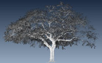
The AL-WSC and Dr. Marzen utilized a tripod-mounted laser scanner to capture every dimension of the trees. The tripod-mounted laser scanner also known as terrestrial light detection and ranging (T-LiDAR) quickly scans and outputs XYZ geospatial data to produce highly accurate 3 dimensional (3D) point cloud of the surveyed scene. The survey can be inspected using a free viewer which allows users to visualize measurement results in 3D, navigate through the surveyed area, perform basic interactive measurements, and generate customized inspection reports. Images and a video of the historical preservation of a live oak at Toomer's Corner are shown here. For more information about T-LiDAR, please call the U.S. Geological Survey Alabama Water Science Center at (334) 395-4120.
3D Video Image of Toomer's Corner Oak Tree
Images of Toomer's Corner Oak Tree
Toomer's Corner Oaks taken from a camera mounted on the T-LIDAR
T-LIDAR 3D model with points colored using a photo drape
T-LIDAR 3D model with points colored represented by laser reflection intensity
T-LIDAR 3D model with points colored represented by laser reflection intensity