Incident: Cobbly Nob Wildfire
 2016-12-8 Map update for Cobbly Nob Fire |  2016-12-7 Map |
Incident: Chimney Tops 2 Fire Wildfire
 2016-12-8 Map update for Chimney Tops 2 Fire |  2016-12-7 Map |
Incident: Camp Branch Fire Wildfire
 2016-12-01 Natahala Branch Fires PIO Map |  2016-11-30 Nantahala Branch Fires PIO Map |
Incident: Pinnacle Mountain Fire Wildfire
12-4-16 IAP Map | 12-3-16 IAP Map |
Incident: Mount Pleasant Fire Wildfire
Mount Pleasant Fire Progression Map 11/26/16 | Mount Pleasant Fire Map 11/26/16 |
Incident: Clear Creek Fire Wildfire
Clear Creek Fire Map 12/1 | 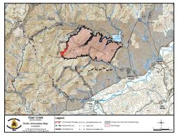 Clear Creek Fire Map 11/29 |
Incident: Cathey Gap Wildfire
 2016-11-24 Nantahala Branch PIO Map |  2016-11-24 Cathey Gap PIO Map |
Incident: Timber Ridge Fire Wildfire
 Timber Ridge Infrared map 11/18 |
Incident: Cliffside Fire Wildfire
 2016-11-26 Nantahala Branch PIO Map |  2016-11-24 Nantahala Branch PIO Map |
Incident: Ferebee Fire Wildfire
 Nantahala Area Map - November 17, 2016 |


