
Wednesday, October 26, 2016
NOAA engineers have created a heads-up navigation display for pilots for coastal imagery acquisition, “ONav.”

Thursday, October 20, 2016

Wednesday, September 14, 2016
NOAA has developed a flexible antenna system for collecting data form PIT-tagged fish. The system is flexible, scalable, easy to deploy, and can be used in both fixed and towed applications.
Tuesday, September 13, 2016
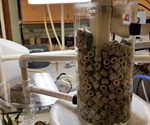
NOAA engineers have recently developed an innovative biological filtration system for aquaculture and aquarium usage that is inexpensive, simple to set up, scalable, and best of all, is self-cleaning.
Wednesday, September 7, 2016
The iGage is a low-cost, portable, rapidly deployable sonar instrument for providing river stage and snow depth information. Developed by NOAA for remote field use in Alaska, the iGage is lightweight, durable, and compact, measuring just 5” x 7” x 3”. The device is solar-powered so it requires no existing site power and can be boom-mounted to a variety of fixed platforms.

Monday, April 4, 2016
Time-of‐flight mass spectrometers are commonly used in analytical chemistry and many other applications. NOAA scientists have developed a new geometry that has improved performance over existing designs and is looking for qualified U.S. manufacturers of scientific instruments to build, market, and sell this device under license.

Wednesday, August 31, 2016

Thursday, April 28, 2016
On Monday, April 25, 2016, the Economic Development Administration (EDA) released aFederal Funding Opportunity (FFO) and began accepting applications for the 2016 round of Regional Innovation Strategies (RIS) Program funding. The application period is open for 60 days and will close at 11:59pm Eastern Time on June 24, 2016.

Thursday, April 28, 2016
Currently live on SBIR.gov , are FY 2016 Small Business Innovation Research (SBIR) and Small Business Technology Transfer (STTR) grant and contract funding opportunities from NSF, DOD, and HHS.

Wednesday, September 24, 2014
NOAA is now seeking manufacturers/licensees to deliver its patented Microparticulate Fish Feeder to market in the United States and globally. Ideal partners will have a proven track record in manufacturing quality scientific instruments domestically and a proven distribution network both in the U.S. and abroad.
Wednesday, September 24, 2014
NOAA is now seeking manufacturers/licensees to deliver its Patent-Pending NOy Cavity Ring-Down Spectrometer to market in the United States and globally. Ideal partners will have a proven track record in manufacturing quality scientific instruments domestically and a proven distribution network both in the U.S. and abroad.

Monday, April 4, 2016
NOAA is seeking a U.S. manufacturer to build and distribute a new device for the non-destructive monitoring of coral health.
CISME ™ is a self-contained, diver-portable instrument designed to non-destructively measure coral respiration and photosynthesis in situ. In situ instruments are needed to promote rapid assessment and monitoring of metabolic health of corals and other benthic organisms affected by ocean acidification, global warming, and other stressors, both anthropogenic and natural.

Thursday, July 16, 2015
Ice Free Wind Sensors (IFWS) are widely used to measure and report wind speed and direction, primarily for the aviation industry. However, the open space around the measurement unit of the wind sensor also provides a convenient space for birds to sit. The subsequent flapping of wings can result in erroneous wind speeds and missing wind data, which is a safety hazard to aviation. In an effort to alleviate the IFWS data issues, the National Weather Service (NWS) developed a bird deterrent device. This device, which keeps the birds from interfering in the sample space of the IFWS, has been tested and deployed within the existing network of over 600 sensors in the US and is now being made available royalty free to industry.

Monday, October 1, 2012
A moored buoy floating at the ocean surface and anchored to the seafloor precisely measures acceleration, pitch, roll, and Earth's magnetic flux field of the buoy over a limited sampling period. The system includes: 1) A buoy, 2) A mooring system, 3) An electronic data logger controlling communications between the system and the on-board remote telecommunications system...
Patent No: US 8,195,395 B2, Teng et al.
If interested in licensing this technology, please complete and return the License Request Form or contact NOAA Technology Partnerships Office directly.

Monday, July 20, 2015
NOAA Researchers have isolated a very bright, red fluorescent protein from coral which can be useful for multi-color labeling experiments and comparisons of gene expression.
![Smart Module for Communications Processing and Interface [Patent Pending]](https://webarchive.library.unt.edu/web/20170119044223im_/http://techpartnerships.noaa.gov/sites/orta/EasyDNNNews/11371/150150p1381EDNthumb11371TPO-Stennis-Miami-3261.jpg)
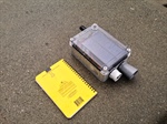
Thursday, October 1, 2015
Engineers at NOAA’s National Data Buoy Center have developed a patent-pending data collection and reporting system, the Smart Module for Communications Processing and Interface, for use on data buoys or similar ocean- or land-based platforms where environmental data are being collected. The benefit of the Smart Module design is that it may be readily retrofitted to a data buoy, weather station, or other similar applications, in order to add additional data acquisition capabilities or features, without disturbing existing communications and data logging equipment at the location. This saves both time and money for testing and certifying new equipment at existing data gathering sites, some of which may be quite remote and difficult to access. By eliminating the risk of compromising an entire system by adding new components, the Smart Module makes adding new capabilities to existing platforms relatively simple and extremely cost effective.

Friday, December 12, 2014
The NOAA Earth Information System (NEIS)TM is a framework of layered services designed to help the discovery, access, understanding, and visualization of data from the past, present, and future. It includes a visualization component named TerraVizTM that is a multi-platform tool, running on desktops, web browsers, and mobile devices. The goal is to ingest "big data" and convert that information into efficient formats for real-time visualization. Designed for a world where everything is in motion, NEISTM and TerraVizTM allow fluid data integration and interaction across 4D time and space, providing a tool for everything NOAA does and the people NOAA affects.

Thursday, February 6, 2014
NOAA is now seeking manufacturers/licensees to deliver its newly-patented Imaging Polar Nephelometer to market in the United States and globally. Ideal partners will have a proven track record in manufacturing quality scientific instruments domestically and a proven distribution network both in the U.S. and abroad.
NOAA offers a wide variety of licensing solutions with flexible terms and reasonable rates. Our licensing process is fast-tracked to allow licensee(s) to move the product from license to manufacture to market in the shortest possible time.

Tuesday, February 19, 2013
Science On a Sphere® (SOS) is a room sized, global display system that uses computers and video projectors to display planetary data onto a six foot diameter sphere, analogous to a giant animated globe. Researchers at NOAA developed Science On a Sphere® as an educational tool to help illustrate Earth System science to people of all ages. Animated images of atmospheric storms, climate change, and ocean temperature can be shown on the sphere, which is used to explain what are sometimes complex environmental processes, in a way that is simultaneously intuitive and captivating.
|