conservation

Conservation All Around Us: The Great Swamp

By Tina Wei

Great Swamp National Wildlife Refuge

Great Swamp National Wildlife Refuge

On June 9th, I assisted David Kluesner, EPA Region 2 community affairs team leader, at an event with the Great Swamp Watershed Association  where he gave a presentation to the community members of Morristown, NJ about the significant steps the EPA is taking to clean up the lower Passaic River.

At the meeting, we heard attendees express strong support for activities to conserve the environment and protect human health. To learn about the community’s relationship with the environment and to see an example of successful, impactful conservation efforts, we visited the nearby Great Swamp National Wildlife Refuge.

This refuge, established by Congress in 1960 and located in Morris County, NJ, is one of the 560 refuges in the Department of Interior’s U.S. Fish & Wildlife Service’s National Wildlife Refuge System. We toured the wonderful Helen C. Fenske Visitor Center, featuring interactive environmental education activities, friendly rangers, and live bird-cams. The refuge’s 7,768 acres of habitat allow for wildlife viewing, photography, and hunting.

We learned that North America is divided into four key flyways for migrating birds. New York City is located in the highly trafficked Atlantic Flyway. This refuge, located only 26 miles away from Times Square, is of great importance, providing a crucial resting place for over 244 species of birds who can’t rest in NYC.
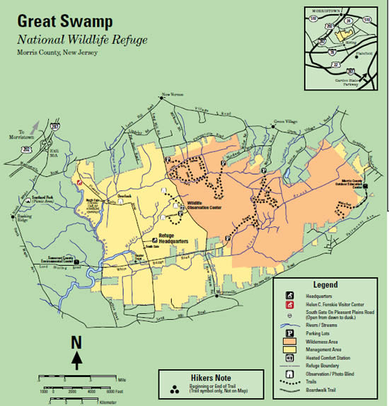
We also learned about this refuge’s unique history. Beginning in 1844, this area’s marshlands were drained and converted to agricultural fields. As these farms became unprofitable and disappeared, alternative uses for this land were proposed, including a 1959 proposal to turn this area into a major airport (what is now Newark Liberty International Airport). In response, community members raised more than one million dollars to buy almost 3,000 acres of the Great Swamp land, donating it to the Department of the Interior to be conserved and reverted back to swampland.

This history is interesting for thinking about key questions regarding conservation:

  • When, why, and how should we conserve the environment?
  • How can we understand our local histories in light of these questions?

Do you know about the local history of a National Wildlife Refuge? What do you think about conservation? Tell us in the comments section!

About the Author: Tina Wei is a summer intern in EPA’s Region 2 Public Affairs Division. She has loved this wonderful learning opportunity, and especially enjoys going on work-related fieldtrips. During the school year, she is an undergraduate student at Princeton University.

Editor's Note: The opinions expressed herein are those of the author alone. EPA does not verify the accuracy or science of the contents of the blog, nor does EPA endorse the opinions or positions expressed. You may share this post. However, please do not change the title or the content. If you do make changes, please do not attribute the edited title or content to EPA or the author.

EPA's official web site is www.epa.gov. Some links on this page may redirect users from the EPA website to a non-EPA, third-party site. In doing so, EPA is directing you only to the specific content referenced at the time of publication, not to any other content that may appear on the same webpage or elsewhere on the third-party site, or be added at a later date.

EPA is providing this link for informational purposes only. EPA cannot attest to the accuracy of non-EPA information provided by any third-party sites or any other linked site. EPA does not endorse any non-government websites, companies, internet applications or any policies or information expressed therein.

Do You Know Your Water Footprint?

By Aria Isberto

Water Footprint Calculator

Sometimes it’s difficult to feel connected to water shortage matters in other places, especially when we’re on opposite coasts of the country or half a world away. But while it may seem like the issue is too big, or too far, and our everyday actions as individuals barely make a drop in the bucket, that’s simply not true!

Earlier this week, GRACE Communications Foundation launched a brand-new online footprint calculator that is focused on household water consumption. The interactive questionnaire uses data from the Water Footprint Network, the U.S. Geological Survey, the U.S. Energy Information Administration, the U.S. Environmental Protection Agency and several other sources to calculate an individual’s water footprint. It takes into account the indoor/outdoor water usage we’re all familiar with, like doing the laundry and washing the car.

Your water footprintIt also calculates virtual water consumption: how much it takes to make the food we eat and the products we purchase. From take-out food to clothing, tech devices and home furniture, all the stuff we buy takes a lot of water to make. Did you know that the average water footprint of an individual in the United States is 2,200 gallons a day?

So take 10-15 minutes of your day to calculate your footprint, or better yet, get the entire household involved! Learn about greywater systems and low flow faucets with your family. Change your answers and see the difference it makes, down to the gallon. You can use it as an educational activity with children (check out our kids section here).

The water footprint calculator is useful in re-evaluating daily habits, and in light of the water shortage issues in the past few years, can also be a reminder of each of our roles in water conservation, no matter where we live. So we can always be mindful consumers of our planet’s resources!

About the Author:
Aria Isberto is an intern at the EPA Region 2 Public Affairs Division. Born and raised in Manila, Philippines, she currently resides in Manhattan and is an undergraduate student at Baruch College. Her passions include music, writing and learning about protecting the environment.

Editor's Note: The opinions expressed herein are those of the author alone. EPA does not verify the accuracy or science of the contents of the blog, nor does EPA endorse the opinions or positions expressed. You may share this post. However, please do not change the title or the content. If you do make changes, please do not attribute the edited title or content to EPA or the author.

EPA's official web site is www.epa.gov. Some links on this page may redirect users from the EPA website to a non-EPA, third-party site. In doing so, EPA is directing you only to the specific content referenced at the time of publication, not to any other content that may appear on the same webpage or elsewhere on the third-party site, or be added at a later date.

EPA is providing this link for informational purposes only. EPA cannot attest to the accuracy of non-EPA information provided by any third-party sites or any other linked site. EPA does not endorse any non-government websites, companies, internet applications or any policies or information expressed therein.

New Guide Provides Climate-Smart Solutions

By Jordan M. West and Susan H. Julius

Cover of publication, "Climate-Smart Conservation"If you’ve ever been to Rocky Mountain National Park, you know that it is a land of majestic peaks, clear blue lakes, and green forested slopes. But these days, huge swaths of dead, reddish-brown trees mar the view. As a result of climate change, ongoing drought and rising temperatures have weakened the trees and triggered more extensive and severe infestations of bark beetles. Whole stands of trees have died as a result.

Scientists have been predicting these types of negative impacts for years and expect them to worsen in the future. At the same time climate change also combines with existing pressures from humans in ways that can cause new and unexpected ecosystem changes. Therefore managers who work to protect our natural resources have to not only address traditional environmental problems, but also anticipate and prepare for future climate-change-driven challenges that they may never have seen before.

Managers recognize that conservation and natural resource management must be viewed through the lens of climate change and are asking:

  • How do we prepare for and respond to the impacts of climate change?
  • What should we be doing differently in light of climatic shifts, and what actions continue to make sense?
  • What approaches are best for integrating climate change into our planning processes, managing for ecosystem changes, and re-evaluating management goals as new scientific information becomes available?

EPA researchers are helping to answer those questions. Agency climate change experts, together with partners from other federal agencies and non-governmental organizations, developed a guide to help natural resources managers integrate climate change into their planning.  Called Climate-Smart Conservation: Putting Adaptation Principles into Practice, the guide covers topics such as setting goals; assessing ecosystem vulnerability; identifying and prioritizing adaptation and implementation options; and monitoring the effectiveness of what’s been implemented.

For each topic, the guide demonstrates how to consider climate change information using examples such as Chinook salmon in the Northwest. In many streams where salmon spawn, climate change is expected to cause increased sedimentation (deposition of mud and sand particles), increased temperatures, and decreased flows in spawning habitats – all of which will be detrimental to the survival of eggs. The guide advises managers on how to consider “climate-smart” information on changes in stream temperatures, flows, and sedimentation rates in different locations as a basis for selecting sites for habitat restoration. This ensures that the restored sites will be good spawning habitat for salmon far into the future.

This and other examples in the guide provide a path forward for systematically incorporating climate adaptation into management planning and implementation. By using the guide, managers can craft management strategies that successfully achieve conservation goals in a changing climate.

About the Authors: Jordan M. West and Susan H. Julius are research scientists in the Global Change Impacts & Adaptation Program of EPA’s Office of Research and Development who contributed to the guide.

Reference: Stein, B.A., P. Glick, N. Edelson and A. Staudt (eds). 2014. Climate-Smart Conservation: Putting Adaptation Principles into Practice. National Wildlife Federation and US Fish & Wildlife Service, Washington, DC.

Editor's Note: The opinions expressed herein are those of the author alone. EPA does not verify the accuracy or science of the contents of the blog, nor does EPA endorse the opinions or positions expressed. You may share this post. However, please do not change the title or the content. If you do make changes, please do not attribute the edited title or content to EPA or the author.

EPA's official web site is www.epa.gov. Some links on this page may redirect users from the EPA website to a non-EPA, third-party site. In doing so, EPA is directing you only to the specific content referenced at the time of publication, not to any other content that may appear on the same webpage or elsewhere on the third-party site, or be added at a later date.

EPA is providing this link for informational purposes only. EPA cannot attest to the accuracy of non-EPA information provided by any third-party sites or any other linked site. EPA does not endorse any non-government websites, companies, internet applications or any policies or information expressed therein.

Take Cover! (With Vegetation)

By Marguerite Huberbuffer

Take cover!

It’s a phrase you yell to protect against something headed your way. But did you ever think that phrase could be applied to pollutants? Well, it can – vegetative cover acts as a defense against non-point source (NPS) pollutants, protecting our lakes, streams, and water bodies.

Vegetative filter strips and riparian buffers  are conservation practices that help control the amount of sediment and chemicals that are transported from agricultural fields into water bodies. They slow down the speed of runoff and capture nutrients, keep more nutrient-rich topsoil on farmers’ fields, and reduces impacts on downstream ecosystems.

To improve water quality in large watersheds, conservation managers need to know what the problems are, where the pollutants originate, and what conservation practices work best.  However, investigating all of these factors at the watershed-wide level is a very difficult and complex task. This is why EPA is working with partners to supplement an existing watershed simulation model to estimate the efficiency of riparian buffers.

USDA’s watershed simulation model, Annualized Agricultural Non-Point Source Pollution (AnnAGNPS), is used to evaluate the effect of farming and conservation practices on pollutants and help decide where to put these practices.  AnnAGNPS also predicts the origin and tracks the movement of water, sediment, and chemicals to any location in the watershed.

To supplement this model, researchers from EPA, USDA, and Middle Tennessee State University developed a Geographic Information Systems–based technology that estimates the efficiency of buffers in reducing sediment loads at a watershed scale.

With the addition of this AGNPS Buffer Utility Feature  technology to the USDA model, researchers and watershed conservation managers can evaluate the placement of riparian buffers, track pollution loads to their source, and assess water quality and ecosystem services improvements across their watersheds.

Riparian buffers and other vegetative cover, such as filter strips, are considered an important, effective, and efficient conservation practice that has been shown to protect ecosystem services at a local level. However, their full impact on a watershed-scale is still subject to ongoing research.


About the Author: Marguerite Huber is a Student Contractor with EPA’s Science Communications Team.

Editor's Note: The opinions expressed herein are those of the author alone. EPA does not verify the accuracy or science of the contents of the blog, nor does EPA endorse the opinions or positions expressed. You may share this post. However, please do not change the title or the content. If you do make changes, please do not attribute the edited title or content to EPA or the author.

EPA's official web site is www.epa.gov. Some links on this page may redirect users from the EPA website to a non-EPA, third-party site. In doing so, EPA is directing you only to the specific content referenced at the time of publication, not to any other content that may appear on the same webpage or elsewhere on the third-party site, or be added at a later date.

EPA is providing this link for informational purposes only. EPA cannot attest to the accuracy of non-EPA information provided by any third-party sites or any other linked site. EPA does not endorse any non-government websites, companies, internet applications or any policies or information expressed therein.

Studying Plant and Insect Response to Environmental Change: A Love Story

By Jessica Dawn Pratt

EPA Fellow Jessica Pratt examines sagebrush.

EPA STAR Fellow Jessica Dawn Pratt

As a native Midwesterner, I was not impressed with the brown and shrubby coastal sage scrub ecosystem that covered hillsides around my new home when I moved to southern California in September of 2005. It was drab, short and prickly compared to the northern hardwood forests to which I was accustomed.

But, as an ecologist, I was excited to live in a “biodiversity hotspot,” a place that rivals the species diversity of many tropical forests and is home to numerous endemic and endangered plant and animal species.

I quickly learned that September was the end of the summertime drought that characterizes California’s Mediterranean climate. As I watched the brown and shrubby hillsides come to life with the winter rains, I fell in love with the coastal sage scrub ecosystem.

In addition to being incredibly diverse and unique, the coastal sage scrub ecosystem also faces many threats, including development, habitat fragmentation, pollution, climate change, invasive species, and wildfire. So, in 2008 when I began the Ph.D. program in Ecology & Evolutionary Biology at the University of California, Irvine, I was determined to work on questions related to its conservation and restoration. A Science to Achieve Results (STAR) Fellowship from EPA allowed me to do just that.

My graduate research examines how California sagebrush (Artemisia californica), an icon of the coastal sage scrub ecosystem, is responding to environmental changes like climate change and nitrogen pollution, and how the response of this important plant species affects the animals that depend on it.

It is my hope that understanding how important species respond to environmental change – and how those responses “scale up” throughout the ecosystem to affect other species – will help us predict and mitigate the impacts.

The first part of this work, published online in Global Change Biology and summarized on UC Irvine’s web site, shows that sagebrush in the southern part of its range will adjust better to climate change than sagebrush in the north.

To determine this, plants collected from a 400-mile stretch of coastal California were grown in experimental plots in Orange County where we tested their response to altered precipitation. Populations from southern sites, where year-to-year rainfall amounts have historically been rather variable, were more flexible to altered precipitation than populations from the north, where precipitation has been more predictable. The findings indicate that a species’ response to climate change won’t always be equal across its range.

Moreover, we saw that year-to-year variability in rainfall at weather stations across the species range is increasing more rapidly in the north, in the very regions where plants may be the least able to tolerate this effect of climate change. As such, including southern sagebrush in northern restoration plantings may be one way to ensure that we give this species an opportunity to adapt to our changing climate.

As we move forward with habitat conservation and restoration in this era of change, it may be prudent to consider the flexibility of the plants that we use in such endeavors so that the greening up of California’s shrubby hillsides each fall may continue long into the future.

About the Author: Jessica Pratt is a Ph.D. Candidate in Ecology & Evolutionary Biology at the University of California, Irvine. Her research examining plant and insect community responses to environmental change in Southern California is funded through the EPA’s STAR Fellowship Program.

Editor's Note: The opinions expressed herein are those of the author alone. EPA does not verify the accuracy or science of the contents of the blog, nor does EPA endorse the opinions or positions expressed. You may share this post. However, please do not change the title or the content. If you do make changes, please do not attribute the edited title or content to EPA or the author.

EPA's official web site is www.epa.gov. Some links on this page may redirect users from the EPA website to a non-EPA, third-party site. In doing so, EPA is directing you only to the specific content referenced at the time of publication, not to any other content that may appear on the same webpage or elsewhere on the third-party site, or be added at a later date.

EPA is providing this link for informational purposes only. EPA cannot attest to the accuracy of non-EPA information provided by any third-party sites or any other linked site. EPA does not endorse any non-government websites, companies, internet applications or any policies or information expressed therein.

Get Out and See the Spring Wildflowers (or Nature’s Filters)

Every mid-winter, I become impatient with winter’s cold, and dreary grays.   I find myself wondering if the world around me is ever going to be warm, lively, and colorful again.  And every spring, as the days grow longer and warmer, my faith is restored, as I see little signs of life popping out of the leaf litter in my yard and native metro woodlands.  In a matter of weeks, the grays, browns, and faded golds of the winter forest floor transform into a carpet of green, white, gold, blue, and purple.  The spring ephemeral wildflowers arrive, and the forest takes on a moist, rich scent and texture.

Busse Forest Nature Preserve

Busse Forest Nature Preserve, a National Natural Landmark in Cook County, IL. (NPS.gov)

Growing up with the Cook County, Chicago forest preserves as one of my family’s most significant recreation destinations, I learned in our annual search for Jack-in-the-Pulpits, to appreciate how this time of delightful delicacy and color, is short-lived, as these forest wildflowers take advantage of the sunlight that temporarily reaches the forest floor, during the time between the end of winter, and the leafing out of the shrub and tree layers above them.


Jack-in-the-Pulpits (NPS.gov)

Jack-in-the-Pulpits (NPS.gov)

These flowers must complete their lifecycles in a matter of weeks, growing, blooming, being pollinated, and setting seed before the dense shade of summer arrives.  It is because their opportunity to thrive is so short, that these plants grow in great numbers, with several adaptations for attracting pollinators: bright colors, enticing scents, and nectar guides on their petals.  Some even have petals which serve as landing platforms for flying insects.

Spring ephemerals are perennials that sprout mostly from underground bulbs and corms, which they have stored with starch during their previous growing season.  They grow close to the ground because there is no competition at this growth level, and this low profile reduces damage from cold winds.  Because the weather in the early spring is still too cold for most flying insects, ants and small ground beetles pollinate most of these plants and disseminate their seeds.

The natural intricacies and beauty of this time in the woods are more than enough to provide a rationale for conservation and restoration, but recent research by the Leopold Center at Iowa State University tells us that these forest floor communities play a big role in water quality as well.  A recent press release from the center tells how certain species of the forest floor are high performers when it comes to capturing and storing nutrients, along with their companion native trees and shrubs.   Together, their root and shoot biomass act as giant natural sponges and filters.   Iowa State has a couple of nice write ups with more information and can be found at:

The weather this year has been unusual but normally I’d suggest you look for the earliest spring ephemerals between late March and early April, especially on moist south-facing slopes warmed by the sun, and on moist bottomlands next to streams.  Later in a normal spring, look for new blooms on rich, moist, well-drained east and north-facing slopes.  Some of the most common spring ephemerals you will see in our region are, Spring Beauty, Dog Tooth Violet, Toothwort, Dutchman’s Breeches, Virginia Bluebell, Wild Sweet William, May Apple, Wake Robin, Bellwort, Bloodroot, Jack-in-the-Pulpit, Putty Root Orchid, and False Rue Anemone.  They will be interspersed with longer lived spring bloomers, like Wild Ginger, Wild Geranium, Jacob’s Ladder, Virginia Waterleaf, Solomon’s Seal, False Solomon’s Seal, and several ferns.

This spring, wander our metro region’s woodland wildlands with a guidebook and marvel at our ephemeral spring beauty.  You can search for carpets of color in the Fort Leavenworth bottomland forests, Swope Park, Burr Oak Woods Conservation Area,  Isley Park Woods Natural Area, Maple Woods Natural Area, the Blue River bottomlands, and Hidden Valley Natural Area.

Roberta Vogel-Leutung is a city girl with rural Iowa and Kansas roots who grew up on the southwest side of Chicago in a family of 13. There, she frequently took refuge at the top of her family’s three story Weeping Willow Tree, and explored the Cook County Forest Preserves with her family, her Boy Scout brothers, and her St. Albert’s Girl Scout Troop.  She’s a big fan of local nature, and works on Urban Waters partnership projects, and various community engagement and sustainability initiatives, from her seat in ENSV where she has been a contractor or employee since 1988.

Editor's Note: The opinions expressed herein are those of the author alone. EPA does not verify the accuracy or science of the contents of the blog, nor does EPA endorse the opinions or positions expressed. You may share this post. However, please do not change the title or the content. If you do make changes, please do not attribute the edited title or content to EPA or the author.

EPA's official web site is www.epa.gov. Some links on this page may redirect users from the EPA website to a non-EPA, third-party site. In doing so, EPA is directing you only to the specific content referenced at the time of publication, not to any other content that may appear on the same webpage or elsewhere on the third-party site, or be added at a later date.

EPA is providing this link for informational purposes only. EPA cannot attest to the accuracy of non-EPA information provided by any third-party sites or any other linked site. EPA does not endorse any non-government websites, companies, internet applications or any policies or information expressed therein.

May is National Wetlands Month

May is National Wetlands Month and three Wetlands of International Importance (designated by the RAMSAR Convention of 1971) are right here in Region 7.  They are Cheyenne Bottoms, Quivira National Wildlife Refuge (both in Kansas) and the Upper Mississippi River Floodplain Wetlands which stretches through Iowa.  These wetlands are three of the most important “flyways” for migratory birds in the country – right here in our backyards, folks!

The Ramsar Convention provides a framework for national action and international cooperation for the conservation and wise use of wetlands and their resources.  The treaty was signed in the city of Ramsar, Iran, in 1971.  There were originally 21 delegates from countries around the world who signed the first treaty.  While it originally emphasized providing habitats for water birds, the Convention has subsequently broadened its scope to address all aspects of wetland conservation and wise use, thereby recognizing the importance of wetlands as ecosystems that contribute to both biodiversity conservation and human well-being. Wetlands cover an estimated 9% of the Earth’s land surface, and contribute significantly to the global economy in terms of water supply, fisheries, agriculture, forestry and tourism.    There are presently 165 Contracting Parties which have designated 2,118 wetland sites for the Ramsar List of Wetlands of International Importance.  Signatories are committed to the designation of wetlands of international importance, as defined by internationally agreed criteria.  That means that the designated wetlands are protected from development.

Let’s take a closer look at the three Wetlands of International Importance….

Cheyenne Bottoms Preserve and Wildlife Area is located in Barton County, Kansas.   With 11,500 acres of marsh land, it is the largest marsh in the interior of the United States.  There are 134 species of birds that breed

Harland Shuster (2012) Center for Great Plains Studies Photo Project

and nest in the area, 148 species that may winter there, and 63 species that are permanent residents.  At least 345 of the 472 species of birds known to occur in Kansas have been recorded at the Bottoms including threatened and endangered species such as Whooping Cranes and Piping Plovers.  Annually over 60,000 visitors come to Cheyenne Bottoms  for the purpose of hunting, bird watching, environmental study, fishing and trapping.  These visitors bring revenue to the nearby cities of St. John, Stafford, Great Bend and Hutchison by their use of hotels, restaurants and other facilities.  Here’s a link to a lot of interesting information and a calendar of migrations and events at Cheyenne Bottoms:

Kansas Wetlands Education Center

Quivira National Wildlife Refuge (QNWR) was established in 1955 to provide wintering and migration stopover habitat for migratory birds along the Central Flyway of North America. These marshes, together with a wide diversity of other habitats, provide food, cover, and protection for a wide assortment of wildlife. Wetlands, large and small, are present throughout the Refuge which has 22,135 acres of rare inland salt marsh and sand prairie.

Egrets. Photo from FWS

US Fish and Wildlife

 Thousands of Canada geese, ducks, and other migratory birds, such as Sandhill Cranes and shorebirds, use these wetlands as they pass through the Refuge on their annual migrations.  The grasslands surrounding QNWR also provide habitat for many mammals including beaver, porcupine, black-tailed prairie dog and armadillo as well as numerous species of grassland fowl.  This link will get you to a map of the driving route through the refuge as well as observation points and what kind of birds and wildlife to look for:

Quivira National Wildlife Refuge

Upper Mississippi River National Wildlife and Fish Refuge is the newest RAMSAR site in Region 7.  Encompassing over 240,000 acres of diverse floodplain habitat, the refuge stretches alongside 260 miles of the Mississippi River through Minnesota, Wisconsin, Illinois and Iowa.  The refuge protects a significant portion of

U.S. Fish and Wildlife, Upper Mississippi River

the Mississippi Flyway, the migration corridor through the center of the country used by over 40% of the migratory waterfowl in the U.S.  Other wildlife includes over 300 species of birds, 31 species of reptiles, and 14 species of amphibians.  Humans also flock to this natural treasure; more than 3.7 million visitors explore these refuges annually and enjoy recreational offerings like hunting, fishing wildlife observation, boating and camping.  For more information click here:

http://www.wisconsinwetlands.org/Gems/W10_Upper_Miss_&_Trempealeau_River.pdf

Visiting a wetland full of beautiful, vibrant life will restore your appreciation of the goodness of the earth.  Enjoy the contrast of organized chaos as flocks land and take flight and the perfect calm as they float and rest.  The mixture of noisy vocalizations and quiet feeding are better than any roller coaster ride. May is National Wetlands Month.  Come experience the smells of wet earth and salty sand.  Let the beauty of our Region 7 wetlands refresh your soul.

Cynthia Cassel is a SEE Grantee where, for 3-1/2 years, she has worked with the Wetland and Streams team in the Water branch.  Cynthia received her BS from Park University and lives in Overland Park where she regularly carries a bag of rocks so as to remain safely earthbound.

Editor's Note: The opinions expressed herein are those of the author alone. EPA does not verify the accuracy or science of the contents of the blog, nor does EPA endorse the opinions or positions expressed. You may share this post. However, please do not change the title or the content. If you do make changes, please do not attribute the edited title or content to EPA or the author.

EPA's official web site is www.epa.gov. Some links on this page may redirect users from the EPA website to a non-EPA, third-party site. In doing so, EPA is directing you only to the specific content referenced at the time of publication, not to any other content that may appear on the same webpage or elsewhere on the third-party site, or be added at a later date.

EPA is providing this link for informational purposes only. EPA cannot attest to the accuracy of non-EPA information provided by any third-party sites or any other linked site. EPA does not endorse any non-government websites, companies, internet applications or any policies or information expressed therein.

How Did You Celebrate Earth Hour?

By: Kelly Siegel

Did you participate in Earth Hour on Saturday?  If not, it’s ok!  Although Earth Hour took place on Saturday March 23, 2013 at 8:30PM, we can make every hour, Earth Hour. 

Earth Hour began in 2007 and has been gaining steam ever since.  It involves world participation in hopes to raise awareness on climate change.  For one hour, everyone turns off their non-essential lights.  My roommates and I did this on Saturday night and realized we don’t need our computers, tv, and phones all going at the same time to have fun!

It is important to realize that we should not celebrate Earth Hour for one hour every year, but every hour of every day!  There are little things we can do every day to raise awareness and fight climate change, that are so simple that they are often forgotten.  Try some of these out: 

  1. Turn off the lights when you leave a room.
  2. Try to fall asleep without your TV or computer on.  Not only does this conserve electricity but you will get a better night’s sleep!
  3. Don’t just put your computer to sleep when not in use, but actually shut it down.  This goes for all appliances. 
  4. You don’t always need to be connected to the internet.  Take a break to read a book or write a blog post!
  5. Get your friends and family involved.  You can brainstorm about other ways to be energy efficient together.

Kelly Siegel is a student volunteer in the EPA’s Air and Radiation Division in Region 5, and is currently obtaining her Master’s degree in Urban Planning and Policy at the University of Illinois at Chicago.  She has a passion for sustainable development, running, and traveling with friends.

Editor's Note: The opinions expressed herein are those of the author alone. EPA does not verify the accuracy or science of the contents of the blog, nor does EPA endorse the opinions or positions expressed. You may share this post. However, please do not change the title or the content. If you do make changes, please do not attribute the edited title or content to EPA or the author.

EPA's official web site is www.epa.gov. Some links on this page may redirect users from the EPA website to a non-EPA, third-party site. In doing so, EPA is directing you only to the specific content referenced at the time of publication, not to any other content that may appear on the same webpage or elsewhere on the third-party site, or be added at a later date.

EPA is providing this link for informational purposes only. EPA cannot attest to the accuracy of non-EPA information provided by any third-party sites or any other linked site. EPA does not endorse any non-government websites, companies, internet applications or any policies or information expressed therein.

Aquatic Conservation Focus Areas for EPA Region 7 – Part II

By Holly Mehl

In November, I laid out the classification hierarchy – the planning regions and assessment units – used by MoRAP and our environmental assessment staff to identify areas on which to focus conservation efforts in aquatic ecosystems of Missouri (download here).  I explained how the Missouri analysis defined these areas at a more refined geographic scale (smaller areas) than for our other three states due to better data availability.  In the end, separate conservation plans were completed for Missouri’s 17 Ecological Drainage Units (EDUs) within which 158 Conservation Focus Areas were identified.  Our modeling showed these areas represent the broad diversity of stream ecosystems and riverine assemblages of species that exist within the state.  To give an exciting example, if each of the 158 areas were adequately protected, 95-100% of targeted species within the state would be protected as well.  Collectively, these areas represent occurrences of all native fish, mussel, and crayfish species in Missouri.  This is very important when you consider that Missouri is home to numerous species that live nowhere else (see pictures below). 

Without going into too much detail, for this blog I’ll talk specifically about what we were attempting to achieve with each component of our conservation strategy:

First, we wanted a separate conservation plan for each Ecological Drainage Unit (EDU).  Learn more about EDU’s from Missouri Department of Conservation here.  Endeavoring to conserve all EDUs is a holistic ecosystem approach to conservation since each one represents an interacting biophysical system and also because no single EDU contains the full range of species found within the state.   Second, we wanted to represent two separate occurrences or populations of each target species within each EDU.  Redundancy in the account of species that together determine each EDU’s distinct biological composition provides a safeguard for their long term persistence.  Our next objective was to conserve an individual example of each Aquatic Ecological System Type (AES-Type) within each EDU.  This helps ensure the wide spectrum of the diversity of distinct watershed types within each EDU are accounted for, including the varying successional patterns within ecosystems and dispersal capabilities of different species.

With each type of AES represented in our conservation strategy, and therefore hopefully protected, we next wanted at least one kilometer of the dominant Valley Segment Types (VSTs) for each size class (headwater, creek, small river, and large river) to be represented as an interconnected complex within each selected AES.  The assumption here is that environmental conditions will be represented to which species have evolved adaptations for maximizing growth, reproduction and survival.  It also represents a wide spectrum of the diversity of stream types within each EDU since the dominant stream types vary among AES-Types.  Further, it accounts for source-sink dynamics which is science of how variation in habitat quality may affect the population growth or decline of organisms.  Attempting to conserve an interconnected complex of dominant VSTs accounts for seasonal changes in habitat brought on by disturbances like droughts or floods.  For example, a headwater species during a prolonged drought may have to seek refuge in larger streams in order to find suitable habitat.

Darters, crayfish, and mussels have limited dispersal capabilities; they cannot move long distances.  We decided that three separate headwater VSTs should be represented within each Conservation Focus Area.  Including multiple headwater segments should account for multiple distinct spatial occurrences of headwater species as well as preserve several high-quality examples of key nursery habitats.

Lastly, many species require multiple habitats for foraging, reproducing, over-wintering, or for disturbance avoidance. We wanted to conserve at least a one kilometer of each priority VST and ensure connectivity of a wide spectrum of diverse habitats (riffles, pools, runs, and backwaters) so that critters could reach their choice habitat. 

My next blog entry in this series will cover the main steps we took to meet these objectives.  Stay tuned for that one.

About the Author: Holly Mehl is an ecologist for EPA Region 7 who helps with water monitoring in the field and performs mapping for EPA Region 7’s program offices when in the office.

Editor's Note: The opinions expressed herein are those of the author alone. EPA does not verify the accuracy or science of the contents of the blog, nor does EPA endorse the opinions or positions expressed. You may share this post. However, please do not change the title or the content. If you do make changes, please do not attribute the edited title or content to EPA or the author.

EPA's official web site is www.epa.gov. Some links on this page may redirect users from the EPA website to a non-EPA, third-party site. In doing so, EPA is directing you only to the specific content referenced at the time of publication, not to any other content that may appear on the same webpage or elsewhere on the third-party site, or be added at a later date.

EPA is providing this link for informational purposes only. EPA cannot attest to the accuracy of non-EPA information provided by any third-party sites or any other linked site. EPA does not endorse any non-government websites, companies, internet applications or any policies or information expressed therein.

The Story of One Cave, and the Bats who Live There

By Vanessa Madden

Myotis sodalis (Indiana Bat)

The year is 1722, French explorer Philipp Renault, guided by Osage Indian legends, emerges from the mist on the Meramec River. Just as the Osage had told him, a large opening could be seen in the bluff above. A cave of gold was waiting to be discovered………. But, as is often the case when French explorers read too much into Osage legends, the promise of gold was never realized. However, the caves along the Meramec River do contain one of nature’s greatest treasures, bats. I doubt the bats made much of an impression on Renault. But at the time, the numerous passageways of this 4.6 mile cavern system undoubtedly provided plentiful wintering and roosting habitat for native bats. Today we know that Missouri caves are home to 14 species of bats (learn about Missouri bats), three of which are federally endangered (Indiana Bat, Gray Bat, and The Ozark Big-Eared). Unfortunately, the cave was not to be left alone. Saltpeter was discovered. Saltpeter was an important resource at the time because it was a key ingredient in gunpowder. What followed was 144 years of mining saltpeter out of the cave, which ended when Confederate troops destroyed a Union gunpowder plant operating inside the cave itself. My guess is that blowing up large amounts of gunpowder was a bit annoying to the bats. Things quieted down a bit after the civil war. The cave was sometimes used by local residents for summer parties and dances. However, people are curious. Word spread of the beautiful features inside the cave. So, in the 1930’s, the cave was opened to the public. Today, tours are conducted year around.

Corynorhinus townsendii ingens (Ozark Big Ear) Wikipedia

Mankind’s use of the cave over the last 300 years has greatly affected the ability of bats to use the cave as habitat. Many of the original entrances and passageways were sealed off, in an attempt to keep trespassers out of the cave. Year around tours have driven the bats into quieter caves nearby. Perhaps the most unexpected threat to the cave ecosystem was the discovery that groundwater contamination at a nearby hazardous waste site was impacting the cave’s air and water quality.

Myotis Auriculus (Gray Bat)

Ironically, all of the historical causes of declining bat populations pale in comparison to the potential affect of a little fungus known as G. destructans or “white-nose syndrome.” Just as its name implies, this fungus has destroyed over 5 million bats in North America, and it is spreading. The human story of this cave is one of adventurers, outlaws, and entrepreneurs. Nature’s story, however, is one of encroachment and loss. Much has been written about the value of bats to mankind. For example, they consume vast quantities of insects (600/hour according to University of Missouri researchers) and pollinate plants. Perhaps more importantly, they have an intrinsic value that we all can recognize. Now, with native bats facing perhaps their greatest challenge yet, we must do all that we can to protect these diminutive creatures. Venessa Madden is a Midwestern girl who grew up playing in creeks and pastures.  Exploring nature motivated her to become an ecologist. She has been with EPA for 14 years, and currently works as an ecological risk assessor.  She is a past winner of EPA’s prestigious James W. Ackerman Award for Ecological Risk Assessment, and conducted a first ever Baseline Ecological Risk Assessment which included evaluating an inhalation pathway for bats.

Editor's Note: The opinions expressed herein are those of the author alone. EPA does not verify the accuracy or science of the contents of the blog, nor does EPA endorse the opinions or positions expressed. You may share this post. However, please do not change the title or the content. If you do make changes, please do not attribute the edited title or content to EPA or the author.

EPA's official web site is www.epa.gov. Some links on this page may redirect users from the EPA website to a non-EPA, third-party site. In doing so, EPA is directing you only to the specific content referenced at the time of publication, not to any other content that may appear on the same webpage or elsewhere on the third-party site, or be added at a later date.

EPA is providing this link for informational purposes only. EPA cannot attest to the accuracy of non-EPA information provided by any third-party sites or any other linked site. EPA does not endorse any non-government websites, companies, internet applications or any policies or information expressed therein.