Region 5

Water Justice and the Grand Cal

The Grand Calumet River after restoration work

The Grand Calumet River after restoration work


Not far from Chicago’s South Side Altgeld Gardens, where Hazel and Cheryl Johnson helped birth and nurture the critical work of environmental justice, meanders the Grand Calumet River.

The two branches of the Grand Cal come together to flow out through the Indiana Harbor Canal into Lake Michigan. These waterways are home for some of the heaviest industrial legacy pollutants in the country. Neighborhoods that line the river experience some of the toughest blight of any urban area. Some 90 percent of the river’s flow comes from municipal and industrial effluent, cooling and process water, and stormwater overflows.

More

Editor's Note: The views expressed here are intended to explain EPA policy. They do not change anyone's rights or obligations. You may share this post. However, please do not change the title or the content, or remove EPA’s identity as the author. If you do make substantive changes, please do not attribute the edited title or content to EPA or the author.

EPA's official web site is www.epa.gov. Some links on this page may redirect users from the EPA website to specific content on a non-EPA, third-party site. In doing so, EPA is directing you only to the specific content referenced at the time of publication, not to any other content that may appear on the same webpage or elsewhere on the third-party site, or be added at a later date.

EPA is providing this link for informational purposes only. EPA cannot attest to the accuracy of non-EPA information provided by any third-party sites or any other linked site. EPA does not endorse any non-government websites, companies, internet applications or any policies or information expressed therein.

Taking Care of Our Coasts

Our coasts support jobs and everyday life for millions of people, and it’s no secret that we’re crowding them: more people are moving to them and more people are going on beach vacations. Coasts are also some of the most biologically rich places on Earth, including those on the Great Lakes, where fish go to reproduce and birds stop during migration.

It’s little wonder that so much demand for our coasts means that so little open coastline remains.

Here in the Great Lakes, that changed a little on September 16th when northeast Ohio’s Lake Metroparks added about 1.6 miles of coastline as a public space. When completed later this year, the park will encompass some 600 acres.

Lake Erie Bluffs-Kayaks-1

More

Editor's Note: The views expressed here are intended to explain EPA policy. They do not change anyone's rights or obligations. You may share this post. However, please do not change the title or the content, or remove EPA’s identity as the author. If you do make substantive changes, please do not attribute the edited title or content to EPA or the author.

EPA's official web site is www.epa.gov. Some links on this page may redirect users from the EPA website to specific content on a non-EPA, third-party site. In doing so, EPA is directing you only to the specific content referenced at the time of publication, not to any other content that may appear on the same webpage or elsewhere on the third-party site, or be added at a later date.

EPA is providing this link for informational purposes only. EPA cannot attest to the accuracy of non-EPA information provided by any third-party sites or any other linked site. EPA does not endorse any non-government websites, companies, internet applications or any policies or information expressed therein.

Three Years Later: EPA Continues to Clean Up Kalamazoo Oil Spill

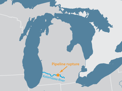
Three years ago today, EPA responded to one of the largest inland oil spills in U.S. history.  When we arrived on scene, oil from a ruptured pipeline was pouring into the Kalamazoo River – a Great Lakes tributary.

map-400

Site of the 2010 Enbridge oil pipeline spill

At the time of the spill, it was raining hard and oil was carried quickly downstream in the fast-moving river – flowing over dams and flooding riverbanks.

Oil completely covered the surface of the river

Oil completely covered the surface of the river

More

Editor's Note: The views expressed here are intended to explain EPA policy. They do not change anyone's rights or obligations. You may share this post. However, please do not change the title or the content, or remove EPA’s identity as the author. If you do make substantive changes, please do not attribute the edited title or content to EPA or the author.

EPA's official web site is www.epa.gov. Some links on this page may redirect users from the EPA website to specific content on a non-EPA, third-party site. In doing so, EPA is directing you only to the specific content referenced at the time of publication, not to any other content that may appear on the same webpage or elsewhere on the third-party site, or be added at a later date.

EPA is providing this link for informational purposes only. EPA cannot attest to the accuracy of non-EPA information provided by any third-party sites or any other linked site. EPA does not endorse any non-government websites, companies, internet applications or any policies or information expressed therein.