Maps and Data
Find maps and charts showing transportation data and trends related to alternative fuels and vehicles.
OR
Sort by:
16 results
-
-
BioFuels Atlas
BioFuels Atlas is an interactive map for comparing biomass feedstocks and biofuels by location. This tool helps users select from and apply biomass data layers to a map, as well as query and download biofuels and feedstock data. The state zoom function summarizes state energy use and infrastructure for traditional and bioenergy power, fuels, and resources. The tool also calculates the biofuels potential for a given area. BioFuels Atlas was developed by the National Renewable Energy Laboratory with funding from the DOE Biomass Program.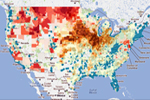
-
-
-
Biomass-Based Diesel RFS2 Mandates and RINs Generated
Last update February 2016
-
-
-
Cellulosic RFS2 Mandates and RINs Generated
Last update February 2016
-
-
-
Cost Components for Domestically Produced Food in 2013
Composition of the cost that consumers paid for farm foods in 2013 Last update August 2015
-
-
-
Global Ethanol Production
Quantity of ethanol produced by country from 2007-2014 Last update March 2016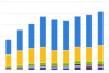
-
-
-
Renewable Fuel RFS2 Mandates and RINs Generated
Last update February 2016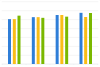
-
-
-
Renewable Fuel Standard Volumes by Year
Last update August 2012
-
-
-
Total Advanced RFS2 Mandates and RINs Generated
Last update February 2016
-
-
-
Total RFS2 Mandates and RINs Generated
Last update February 2016
-
-
-
TransAtlas
TransAtlas is an interactive map that uses a Google Maps interface to display: Existing and planned alternative fueling stations Alternative fuel production facilities Light-duty vehicle density Roads and political boundaries Users can customize the map display and print and query the underlying data. TransAtlas is part of a suite of geographic analysis tools for renewable energy developed at the National Renewable Energy Laboratory.
-
-
-
U.S. Biodiesel Production, Exports, and Consumption
Trend of U.S. biodiesel production, exports, and consumption from 2001-2015 Last update September 2016
-
-
-
U.S. Corn Productivity and Land Use
Trend of corn yield and acres of corn harvested from 1866-2014 Last update August 2015
-
-
-
U.S. Corn Use by Market Year
Annual usage of the U.S. corn crop according to end product or destination Last update August 2015
-
-
-
U.S. Ethanol Plants, Capacity, and Production
Trend of ethanol plant buildup from 2002-2014 Last update July 2015
-
-
-
U.S. Soybean and Corn Prices
Trend of soybean and corn prices, adjusted for inflation, from 1866-2014 Last update August 2015
-
-
-
U.S. Total Corn Production and Corn Used for Fuel Ethanol Production
Trend of corn produced in U.S. and quantity used for ethanol from 1986-2016 Last update September 2016
-


BioFuels Atlas is an interactive map that allows users to view and compare the locations of biomass feedstocks, biofuels production facilities, bioenergy plants, biofuels stations, and densities of vehicles that can run on biodiesel or E85. Users can select from and apply biomass data layers to customize maps according to their needs. BioFuels Atlas was developed by the National Renewable Energy Laboratory with funding from the DOE Bioenergy Technologies Office.
Print