Kansas City

The Foundation Has Been Laid: Helping the Community That Made Me Who I Am

By Stanley Walker

Stan WalkerIn 1969, I first walked up the steps to Horace Mann Elementary School in Kansas City, Mo. The steps were strong, sturdy, and built on a foundation of community, love, and support. I was so excited to be able to go to school like the other kids in the neighborhood, more importantly being able to walk with my older brother and sister. It was a great feeling. At five years old, I felt like I was finally growing up by being able to walk up those steps and enter the school as a real Horace Mann student.

For the next eight years, I would be in a learning environment filled with knowledge, wisdom, and street smarts. Day in and day out, I would be in the presence of the best teachers, smartest students, and of course, some of the greatest athletes in the area.Horace Mann Elementary School in Kansas City, Mo.

On Sept. 23, 2015, I had the opportunity to walk up the steps of hope again. However, it was under different circumstances. The Environmental Protection Agency was awarding Kansas City, Mo., a grant to help communities such as the Ivanhoe Neighborhood revitalize that area.

Although the school has been torn down, the bricks have been saved and are being reused on the site. Saving the bricks serves as another symbol for me. The bricks have endured strong winds, blisteringly hot summers, and bitterly cold winters. Like the bricks, many folks in the community have endured the various seasons of life. You can sometimes see the chips and scars left by the seasons on the faces of the community. However, the strength for the community to get up one more time from the poverty, urban flight, crime, and neglect reminds me how Evander Holyfield stormed back after taking a vicious punch from Riddick Bowe. I watch the community get back on its feet before the count of 10 with the addition of the Aldi’s store on 39th and Prospect, and the duplexes being built to replace the school.

While at the celebration, someone Stan Walker poses for photofound a piece of an old chalkboard. It evoked memories of being able to go up to the board and work a problem in front of my class, which was a real honor. For almost 50 years, there were a couple of pillars like Mrs. Margaret May who kept the foundation strong and pieced it back together when it began to crumble. As I stood next to her on that September day, I could not thank her enough for preserving the foundation of a strong community. Much of who I was, who I am, and who I will become will still come back to the foundation built by Horace Mann Elementary School.

About the Author: Stanley Walker manages the Superfund Technical Assistance and Reuse Branch at EPA Region 7. 

Editor's Note: The opinions expressed herein are those of the author alone. EPA does not verify the accuracy or science of the contents of the blog, nor does EPA endorse the opinions or positions expressed. You may share this post. However, please do not change the title or the content. If you do make changes, please do not attribute the edited title or content to EPA or the author.

EPA's official web site is www.epa.gov. Some links on this page may redirect users from the EPA website to a non-EPA, third-party site. In doing so, EPA is directing you only to the specific content referenced at the time of publication, not to any other content that may appear on the same webpage or elsewhere on the third-party site, or be added at a later date.

EPA is providing this link for informational purposes only. EPA cannot attest to the accuracy of non-EPA information provided by any third-party sites or any other linked site. EPA does not endorse any non-government websites, companies, internet applications or any policies or information expressed therein.

Gleaning Gourds

By Jim Callier

Last month I shared with you about noteworthy efforts to feed the poor here in Kansas City by “gleaning.”  I wanted to follow up by sharing the conclusion to this story and the positive impact this experience had on me, the community, and the environment.

Food is Too Good To Waste!

One of the reasons for my enthusiasm about the gleaning effort is that EPA’s Food Recovery Hierarchy, places feeding hungry people near the top in terms of preferred alternatives to wasting.  Considering higher uses of food is important because in addition to the social and economic benefits of not wasting food, alternatives to landfilling are important for the planet.

Food waste, especially when disposed of in a landfill, is a significant contributor of greenhouse gases through the production and release of methane, a potent greenhouse gas and contributor to climate change.  In the US, a significant amount of food waste is disposed of in landfills every day – more than 34.5 million tons in 2011.  This is enough food waste to fill the Rose Bowl each day!  What’s more, many in the US do not have enough to eat.  Hunger is a serious problem in the US – with 1 in 5 children going to bed hungry.

The gleaning effort organized by SoSA West that took place in Kansas City this past November was one of many notable efforts to take food that otherwise would be wasted and get it to those in need. I was honored to be a part of this effort and am glad to be able to share my account.

Getting Squash to Those in Need

A couple of days following the gleaning event, squash1I met up with volunteers to make deliveries of gleaned squash to pantries and shelters.  I met Scott, a volunteer for Operation Breakthrough who would drive the truck and Jesse, another volunteer who would sack and deliver the squash.  Scott and Jesse were interested in my involvement in the project so I explained EPA’s food recovery program and the importance of food recovery to the economy and environment.  When I mentioned feeding people as a beneficial alternative to wasting and our partnership with USDA, they were enthusiastic and better understood the bigger picture of food waste in the US.

We began our journey for the day with an initial list of 6-7 stops and loaded with 4 full skid boxes — over 4000 pounds of squash, and numerous bushel-sized sacks to fill.   At every stop, we met incredible people.  Some were chefs that would prepare the squash and some were people in need.  Everyone we met was incredibly appreciative, but I felt the most privileged, having the opportunity to be part of the effort.

squash22One of the stops that had a particular impact on me was a men’s shelter.  While we were there a number of men came over to our truck to help unload a couple hundred pounds of squash.  Although the honor was ours, they were truly grateful.  As we prepared to leave the shelter, a couple of men who were in a van leaving for an errand backed up, stopped, rolled the window down, and called us over to once again express appreciation.  This totally unexpected, additional act of gratitude really hit home for me on the value of the effort made by all of the organizations and volunteers.

As I walked back to the delivery truck, I noticed a black POW MIA flag.   Subsequently, I did a little research and learned that this organization’s mission includes helping veterans and houses close to 200 veterans.  This really made a mark on me because Veterans and active duty service personnel have a special meaning for me.  One reason is that my father and eldest brother were veterans; my father served as a Navy pilot in the Pacific theater during World War II and my brother served in the Army during the Vietnam era.  Also, I have met numerous veterans and service members throughout my work at EPA.  While working in the Commonwealth of the Northern Mariana Islands assessing and cleaning up WWII sites, I met current and former Navy Explosive Ordnance Detachment Officers, also known as “bomb techs.”  squash3

Meeting these appreciative vets and others on our journey that day was a fantastic experience.  In all, we made about 13 stops and delivered most of the squash that day.   I felt uplifted to meet the generous volunteers and grateful recipients.  It is encouraging to know that efforts like this are going on and that what we do at EPA through the Food Recovery Challenge is necessary and important.  As I witnessed by participating in this gleaning effort, the work of many at food waste reduction is turning what would have been left behind as waste into an opportunity to make lives a little better.

Jim Callier is Chief of the Resource Conservation and Pollution Prevention Section at EPA in Kansas City and has thirty years of experience working at EPA, primarily in Region 7. Jim has both working and management experience in many of EPA’s programs including hazardous and solid waste, brownfields, and pollution prevention. He is a graduate of the University of Missouri at Rolla with a B.S. Degree in Geological Engineering and is a Registered Professional Geologist in the State of Missouri.

Editor's Note: The opinions expressed herein are those of the author alone. EPA does not verify the accuracy or science of the contents of the blog, nor does EPA endorse the opinions or positions expressed. You may share this post. However, please do not change the title or the content. If you do make changes, please do not attribute the edited title or content to EPA or the author.

EPA's official web site is www.epa.gov. Some links on this page may redirect users from the EPA website to a non-EPA, third-party site. In doing so, EPA is directing you only to the specific content referenced at the time of publication, not to any other content that may appear on the same webpage or elsewhere on the third-party site, or be added at a later date.

EPA is providing this link for informational purposes only. EPA cannot attest to the accuracy of non-EPA information provided by any third-party sites or any other linked site. EPA does not endorse any non-government websites, companies, internet applications or any policies or information expressed therein.

Mussels in the Blue III – Water Quality and Threats

By Craig Thompson

Over the past two weeks I’ve told you about  one of my favorite rivers (the Blue River) and favorite aquatic species (Mussels).  Although the Blue River currently supports nearly 17 mussel species, habitat alteration, pollution, and the introduction and spread of non-native clams (Corbicula) have led to the extinction of some species from the river.  More than half the surviving native mussel species at 159th exhibit declining populations.  Mussels as a group are considered one of the most imperiled freshwater organisms in North America.  Mussels are in serious danger and many of the declines in mussel populations at 159th and other sites on the river can be attributed to flood-control and urbanization projects.

Many of the lower reaches of the Blue River have been channelized.  In fact, when we arrived last summer (2012) to sample the Byram’s Ford site, we found the river had been altered and straightened.  Flood-control projects like the one at Byram’s Ford result in the loss of habitat for mussels and other aquatic life.  The original habitat at this site was riffles, runs, and some backwaters with a medium bend in the river.  Now, the river is deep and straightened, and it is hard to get in to sample.  Riffles aerate the river and provide essential dissolved oxygen for many aquatic organisms.  Bass, sunfish, madtoms, darters, and many minnow species use riffles for food, reproduction and shelter.  Riffles are important for mussels as well.  In 2009, this site had a productive mussel community including one SINC species, the Yellow sandshell (See the Table below).

159table

The original riffles, gravel bars, and adjacent backwaters also were important feeding areas for waterfowl and herons.  Ultimately, with the loss of riffle habitat and the increase in water depth, we may see a decline in the diversity and abundance of some mussel species at this site.  The following picture of the Blue River at Coalmine Road (not far from the Stadiums) gives you an idea of what the river looks like lower in the watershed.

blueatcoalmine

Since coming on board with EPA, I have observed a number of changes to the upper Blue River basin.  When I was enrolled in classes in the 1970s at Johnson County Community College, Antioch Road was just two lanes and the land south of the college was mostly farmland and pastureland.  Over the years, construction crews have widened many of these roads to accommodate the accelerated growth moving into south Johnson County.  On my field trips to stream monitoring sites in the county, I have observed many water quality problems associated with all this new growth.  I am usually disgusted by the way construction crews build silt fences and how these fences never do their intended job of preventing exposed dirt from running off into waterways.  These types of activities contribute to the runoff of sediments into streams which can bury mussels.  Also, mussels are very sensitive to many other types of pollution as a result of stormwater runoff from parking lots and residential lawns.  Heavy metals, pesticides and herbicides are some of the constant water quality problems mussels must face in the Blue.  In the future, the conservation of native mussels will depend upon how well we protect the land from soil erosion and stormwater runoff.  Basically, we need to take care of our watersheds.

Blueriver

Over the years I have been collecting and observing freshwater mussels from streams throughout Kansas and Missouri.  The Blue River at 159th (shown above during high water) is a gem of a site.  At this time, I believe that the physical, chemical and biological attributes are very good at this site.  Every time I have sampled this urban stream site, there is good flowing, permanent water, which most mussel species require.  It will be interesting to discover in the coming years what aquatic species are able to live and tolerate the rapid environmental changes that are occurring in the Blue River basin.  And, this is especially true for the mussels in the Blue at 159th.

Craig Thompson lives near the mussel-less (except for Asian clams) Brush Creek, a tributary of the Blue River.  He is a Life Scientist with the Environmental Assessment and Monitoring Branch (EAMB).  Craig joined EPA in 2009 after spending thirteen years with Kansas Department of Health and Environment.  He assists EAMB staff with water quality and biological sampling surveys throughout the Region 7 area.

Editor's Note: The opinions expressed herein are those of the author alone. EPA does not verify the accuracy or science of the contents of the blog, nor does EPA endorse the opinions or positions expressed. You may share this post. However, please do not change the title or the content. If you do make changes, please do not attribute the edited title or content to EPA or the author.

EPA's official web site is www.epa.gov. Some links on this page may redirect users from the EPA website to a non-EPA, third-party site. In doing so, EPA is directing you only to the specific content referenced at the time of publication, not to any other content that may appear on the same webpage or elsewhere on the third-party site, or be added at a later date.

EPA is providing this link for informational purposes only. EPA cannot attest to the accuracy of non-EPA information provided by any third-party sites or any other linked site. EPA does not endorse any non-government websites, companies, internet applications or any policies or information expressed therein.

Mussels in the Blue II: Relative Abundance of Species in the Blue

By Craig Thompson

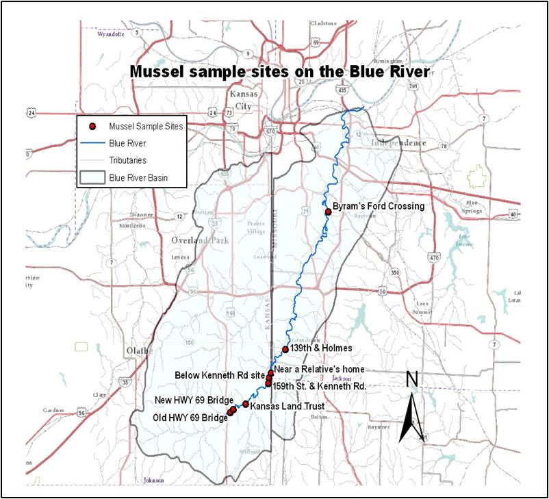
Last week I posted a blog article discussing Mussels in the Blue River,  and the work performed by the Kansas Department of Health and Environment (KDHE) and by EPA Region 7 over the last several decades to conduct qualitative mussel surveys.  Last weeks blog focused mostly on rare species.  This week I will be discussing the relative abundance of species in the Blue River (collection sites are shown below in the Figure 1.).

BlueRiver

Figure 1. Mussel sample sites on the Blue River

Corbicula fluminea

Figure 2. Corbicula fluminea

To record mussel community information, KDHE and EPA used the following – waterbody, location, scientific name, common name, collection date, collectors, relative abundance, shell condition, and width/length measurements.  I mentioned last week that there are about 45 species of mussels recorded for the state of Kansas (approximately 69 for Missouri).  One of the things I enjoy while collecting mussels is to identify them by their scientific name.  With only 45 species of mussels compared to hundreds of species of aquatic insects they are much easier to remember and memorize.   One of the most abundant shells found at 159th is from the Asian clam (Corbicula fluminea, Figure 2).  Corbicula is a small, non-native clam that was introduced years ago and has since populated most waterbodies of the United States.  It has many evenly-spaced concentric ridges on its outer shell, and it has been collected at every site along the Blue.  At this time, there are no Zebra mussels (Dreissena polymorpha) in the Blue.

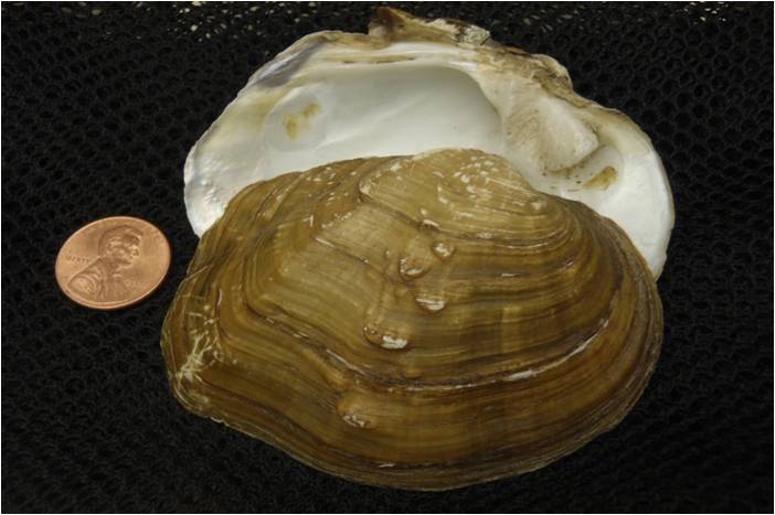
The most common native mussel species found at 159th are the Mapleleaf, Threeridge, Giant floater, Pondmussel, and White heelsplitter (Table 1).  These species also appear frequently at other sites along the river.  A Mapleleaf (Quadrula quadrula, Figure 3) has a thick shell that is quadrate in shape.  It has a line of pustules on the outer part of its shell.  When I am sampling any site on the Blue I usually find Mapleleafs together with Threeridge mussels.  Threeridge (Amblema plicata) has a thick shell with three horizontal ridges (sometimes more).  Giant floater (Pyganodon grandis) is another mussel with an interesting name.  If you want to have some fun with the shells, place the shells in the water with the inside part (the pearly interior) facing up and you will see them float down the river.  The shell of this mussel is very thin and can break easily in younger specimens.  Older specimens can get quite large and up to ten inches in length.  Pondmussels (Ligumia subrostrata) are common in small streams and ponds throughout the area.  The shell is elongate and smooth with growth lines.  You can easily tell the sexes of this species (called sexual dimorphism).  Males have a longer shell that is more pointed than females.  Female Pondmussels are shorter and more inflated.  White heelsplitter (Lasmigona complanata) is a large mussel associated with medium to large rivers and it’s shell is ovate and smooth and the nacre is white.  This mussel may have received its common name from people stepping on it barefoot.

abundancetable

Table 1. Relative abundance of mussel shells recorded during 21 sampling visits from the Blue River at 159th St. & Kenneth Rd. (KDHE & EPA 1991-2011). Relative abundance recorded as present < 3; common >3 but < 8; abundant >8.

One day, and on my own time, I just decided to take a look upstream from 159th.  I received permission to get on the river from a piece of property managed by the Kansas Land Trust.  In September, I found five different species of mussel shells (Table 2) on a gravel bar, and I also observed several live Mapleleaf and Threeridge mussels in a shallow run.  These two species are very common in streams in Kansas.  Their thick shells were once used to make buttons but are now used to produce pearls for the cultured pearl industry.  Monkeyface and Bleufer mussels are used for this purpose as well, but they are found only in clear flowing streams in southeast Kansas.  Another site I explored recently was about a mile downstream from 159th.   The site is called “Near a relative’s home”.  I was visiting my nieces on their birthday and saw a great opportunity to access the Blue from their backyard.  Anyhow, I was more interested in collecting mussels that day than eating cake and ice cream.  When I finished my cake, I hurriedly crawled down the banks of the Blue to check for mussels.  My young nieces enjoyed the shells I collected from the river.  As I recall, I gave them some Mapleleaf shells, which they thought were very cool.  Anyway, there was nothing rare or unusual, but it was exciting to find 10 species (Table 2) at this site.

159table

Table 2. Number of mussel species found at Blue River sample sites upstream and downstream from 159th Street site (2009-2013, EPA Region 7)

Mapleleaf (Quadrula quadrula)

Figure 3. Mapleleaf (Quadrula quadrula)

Next week stay tuned for the thrilling third and final installation of Mussels in the Blue, where I will discuss the water quality challenges that face the Blue River.

Craig Thompson lives near the mussel-less (except for Asian clams) Brush Creek, a tributary of the Blue River.  He is a Life Scientist with the Environmental Assessment and Monitoring Branch (EAMB).  Craig joined EPA in 2009 after spending thirteen years with Kansas Department of Health and Environment.  He assists EAMB staff with water quality and biological sampling surveys throughout the Region 7 area.

Editor's Note: The opinions expressed herein are those of the author alone. EPA does not verify the accuracy or science of the contents of the blog, nor does EPA endorse the opinions or positions expressed. You may share this post. However, please do not change the title or the content. If you do make changes, please do not attribute the edited title or content to EPA or the author.

EPA's official web site is www.epa.gov. Some links on this page may redirect users from the EPA website to a non-EPA, third-party site. In doing so, EPA is directing you only to the specific content referenced at the time of publication, not to any other content that may appear on the same webpage or elsewhere on the third-party site, or be added at a later date.

EPA is providing this link for informational purposes only. EPA cannot attest to the accuracy of non-EPA information provided by any third-party sites or any other linked site. EPA does not endorse any non-government websites, companies, internet applications or any policies or information expressed therein.

Mussels in the Blue

By Craig Thompson

For the last four years I have been sampling wadeable streams throughout the metropolitan Kansas City area.  I am part of the water monitoring team within the Environmental Assessment and Monitoring Branch (EAMB) at EPA Region 7.  I grew up in Mission, Kansas.  I was always outdoors exploring the woods behind my parents house and wading the waters of Turkey creek and other creeks in my neighborhood.  Now, I am responsible for collecting water and biological samples from some of these same creeks.  My particular area of expertise is macroinvertebrate sampling (freshwater mussels and aquatic insects).  I am fascinated with the mussel community information that has been collected from several sample sites on the Blue River (Figure 1).

BlueRiver

Figure 1

During the 1991-2011 sampling seasons, qualitative mussel surveys were conducted on the Blue River by Kansas Department of Health and Environment (KDHE) and by EPA Region 7.  The upper Blue River supports a diverse community of mussels compared to the lower Blue River.  The Blue River at 159th Street and Kenneth Road has one of the most diverse mussel communities of any urban stream site in the metropolitan area (Table 1).

table1


There are approximately 45 species of mussels found in Kansas.  Kansas Department of Wildlife, Parks and Tourism (KDWPT) lists 6 endangered and 5 threatened species.  In addition, they have a category called “species in need of conservation”, or SINC species.  There are at least 17 species of mussels found in the Blue River. The site at 159th has one endangered and four SINC mussel species.  The Mucket is an endangered mussel found typically in the Marias des Cygnes river basin (several miles south of 159th).  This rare mussel is outside its normal range, but it may have occurred in the Blue River (Missouri River Basin) historically.  The Creeper, Fatmucket, Wabash pigtoe and Yellow sandshell have interesting names and are SINC species.  Creeper (formerly called Squawfoot) is a rare find for this river and only one shell was collected at 159th.

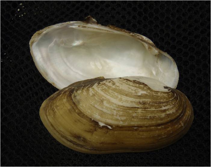
Fatmucket is an unusual name for a mussel.  The “fat” part of this mussel’s name probably came from describing the swollen shape of the shell of this species.  This characteristic is very common in older individuals and in females.  This mussel is doing fair at 159th with a few weathered shells found at other sample sites along the river.  Wabash pigtoe and other freshwater mussels are recognized by the shape of their shell.  They have either animal hoof or foot characteristics.  Names like Fawnsfoot, Round pigtoe, Deertoe, Elktoe and Rabbitsfoot are some of the species in this group.  Wabash pigtoe is also doing fair at 159th with some recent and weathered shells found at other sample sites.  The Yellow sandshell is a beautiful mussel.   The outer layer of the shell (called periostracum) is a distinct yellow and the nacre (the iridescent, inner layer) is silvery-white (Figure 2).  The Yellow sandshell is doing well at 159th with some recent shells (unweathered shells) found in 2011.  Also, a few recent shells have been collected at other downstream sites.

Yellow sandshell (Lampsilis teres)

The other rare mussels identified in the survey may possibly be extirpated (locally extinct) from the Blue River basin.  The Pimpleback is common in other streams in the state but is rare in the Blue.  It has numerous raised structures on the outer part of its shell called pustules.  I have not observed this species for a long time and the last time shells were collected was in 2005.  The Pistolgrip is an easy mussel to identify (general shape of a pistolgrip).  It is a thick-shelled mussel that is elongate with distinct knobby ridges and pustules. The last time it was discovered at 159th was in 1993.  The Plain pocketbook shell is oval and large.  It is usually present at 159th and other sites along the Blue but not in high numbers.  And, the shell condition is usually weathered or relict.  Finally, the Lilliput is a mussel that is hard to find because of its bean-shaped size.  Some shells measure around an inch in length and only a few have been collected at 159th.

Next week, I will discuss the relative abundance of species found in the Blue as well as some of  the main water quality problems facing mussels in the Blue.

Craig Thompson lives near the mussel-less (except for Asian clams) Brush Creek, a tributary of the Blue River.  He is a Life Scientist with the Environmental Assessment and Monitoring Branch (EAMB).  Craig joined EPA in 2009 after spending thirteen years with Kansas Department of Health and Environment.  He assists EAMB staff with water quality and biological sampling surveys throughout the Region 7 area.

Editor's Note: The opinions expressed herein are those of the author alone. EPA does not verify the accuracy or science of the contents of the blog, nor does EPA endorse the opinions or positions expressed. You may share this post. However, please do not change the title or the content. If you do make changes, please do not attribute the edited title or content to EPA or the author.

EPA's official web site is www.epa.gov. Some links on this page may redirect users from the EPA website to a non-EPA, third-party site. In doing so, EPA is directing you only to the specific content referenced at the time of publication, not to any other content that may appear on the same webpage or elsewhere on the third-party site, or be added at a later date.

EPA is providing this link for informational purposes only. EPA cannot attest to the accuracy of non-EPA information provided by any third-party sites or any other linked site. EPA does not endorse any non-government websites, companies, internet applications or any policies or information expressed therein.

Visualizing Time Series E.Coli in the Blue River Watershed

By Scott Malone

Previously I provided a glimpse into the world of data management and the various challenges associated with formatting and managing geospatial data. After explaining the process of data management and customization in my last post, let’s review my experience with creating a time series animation.

KCWaterBug Main Legend

KCWaterBug Main Legend

My animation, as I mentioned previously  started with data.  I used the modeled E Coli measurements as an overall indicator of each site’s water quality.  Remember that modeled E Coli readings occur every fifteen minutes and I used a four month time period which meant more than 700,000 readings all together!   Attempting to symbolize every reading within the animation would have been a classic case of too much information. With this in mind, I decided to use the daily maximum value of the modeled E Coli readings cutting down the volume of the data while still maintaining a representative of the daily water quality. Visualizing one value per day made the most sense for my time series animation and the observer’s sanity. To distinguish the varying states of water quality I used threshold values pulled from the Water Bug mobile application offered through KCwaters.org as a template.

 You can find out more about Kansas City water quality and how
the KCWaterBug mobile app keeps the public informed here.

 As a background for the time series animation I used a land cover map (2006 NLCD)  in hopes of generally linking the extent of an areas development to stream water quality. Looking at the animation, you can clearly see the stream located almost fully in the heart of the urban core, Brush Creek, has some serious water quality issues.  The two telemetry sites on the stream change from red to yellow only once over the four month time span of the animation. In no way is this a definitive statement about the link between urban development and water quality however it is interesting to note that  streams considered “fringe urban streams” located in less developed areas such as Wolf Creek have a much more diverse range of water quality classifications during the same time period.

 There is more to water quality than rain storms and E. Coli.
Find out about PAHs in Kansas City streams here.

Another interesting trend visible in the time series animation is how E Coli levels follow precipitation events. Using precipitation data from StormWatch.com a Johnson County, Kansas regional weather service I was able to compare date precipitation events with the modeled E Coli. After a rainfall of an inch or so, modeled E Coli levels elevate, often into the red zone indicating a stream with waters unfit for contact (see fig. 1). Within a day or two most of the streams readings return to a safer level. All this is to say it would be safest to give a stream a couple of days after a heavy rainfall before swimming.


KCWater Stream Monitors

The stream monitors advise no water contact after a rain event.

Constructing a visually appealing and informative time series animation while not near as trying as the data management side of the project was not without its challenges. All of the classic challenges of constructing a static map combined with the unique trials a time series animation presents made this project a very interesting endeavor. Managing and properly formatting a massive amount of time sensitive data while presenting an understandable and informative final product was a complicated yet rewarding experience. However my course work up to this point was more useful in addressing the problems that arose relating to cartography and typical GIS quirks, as opposed to the data management side of the project which was eye opening.

As I began my internship here at the EPA’s Region 7 I considered myself a competent GIS user during my time here I was exposed to a wide range of “Information” issues that made me if only for a second question that assumption. However as I wrap up this experience I can say with confidence that I have a deeper understanding of the intricacies of data management and map construction. Working on a project intended to provide the public with a greater understanding of water quality issues on a local level was rewarding in its own right on top of which the experience and knowledge I gained will help me as I move forward toward a career. I would like to take this opportunity to thank Casey McLaughlin and all the fine folks here at region 7 for their help this summer and suggest that you take a look at the fruit of my labor.

Scott Malone recently graduated from the University of Kansas with a degree in Environmental Studies.  He spent part of summer 2012 as a voluntary intern with the Environmental Services Division where he worked with LiDAR, land cover, and water quality telemetry data.

Editor's Note: The opinions expressed herein are those of the author alone. EPA does not verify the accuracy or science of the contents of the blog, nor does EPA endorse the opinions or positions expressed. You may share this post. However, please do not change the title or the content. If you do make changes, please do not attribute the edited title or content to EPA or the author.

EPA's official web site is www.epa.gov. Some links on this page may redirect users from the EPA website to a non-EPA, third-party site. In doing so, EPA is directing you only to the specific content referenced at the time of publication, not to any other content that may appear on the same webpage or elsewhere on the third-party site, or be added at a later date.

EPA is providing this link for informational purposes only. EPA cannot attest to the accuracy of non-EPA information provided by any third-party sites or any other linked site. EPA does not endorse any non-government websites, companies, internet applications or any policies or information expressed therein.

Biking for Sustainability

By Shannon Bond

GT_Banner

I strap on my helmet, slip into my gloves, and sling my hydration pack across my shoulders. It’s time to find adventure. I swing my leg over the saddle and click my right shoe into the peddle. A lot of the time I find my adventure on the back of a mountain bike, flying down all of the single track dirt trails I can find. Rocky climbs, fast descents, quick and flowing terrain, it’s all meditative.

I’ve ridden for years, but since coming to the EPA a few thoughts have lodged themselves into my consciousness. One of those thoughts creeps into my mind on every ride; as my muscles are screaming and I’m focusing on, well, my focus, I think about sustainability.

Merriam-Webster defines sustainable as, “of, relating to, or being a method of harvesting or using a resource so that the resource is not depleted or permanently damaged.” (http://www.merriam-webster.com/dictionary/sustainable)

Trails and parks are a perfect example of sustainability. They not only provide a refuge for wildlife, they also provide a refuge for people. These areas work well as an escape from the daily barrage of work and technology, a personal connection with nature, or a great way to exercise. Sustainability isn’t just about our physical environment, though; it’s about us, too. On the EPA website, it describes sustainability in the following way:

“Sustainability is based on a simple principle: Everything that we need for our survival and well-being depends, either directly or indirectly, on our natural environment. Sustainability creates and maintains the conditions under which humans and nature can exist in productive harmony, that permit fulfilling the social, economic and other requirements of present and future generations.” (http://www.epa.gov/sustainability/)

I would say that these trail systems definitely promote that productive harmony, as well as fulfill some of our social needs. I’ve come to understand that these trails don’t happen by themselves though. Parks don’t just sprout up for people to hike and explore, and bike-friendly urban environments don’t just happen, they are built. A lot of planning goes into public use areas, and a lot of maintenance is required to keep them going.

You don’t generally think about Kansas City and biking, especially mountain biking, but the scene has grown. It’s an exciting time for the bike community in Kansas City. According to the Earth Riders Trail Association (http://www.earthriders.org/) we have at least thirteen maintained trail systems in the K.C. metro area. I know from talking to some of these dedicated individuals that there are even more planned.


ERTA Trails

Now that I realize what it takes to maintain these trails, I appreciate them even more, and the folks who get out and work on them. Initially, there has to be an agreement with the land owners. Those owners can be county, federal, or state. Then it takes coordination with the land managers to plan the trail system in an environmentally-sustainable way. After that, a host of volunteers spend countless hours on trail work days. Even after the trails are built, those work days keep coming. All of this behind-the-scenes work is hidden from the everyday user. To lend a hand, though, you can check the group’s websites and pick any number of maintenance days to show up at:

http://earthriders.com
http://www.earnyourdirt.org/
http://www.kansascyclist.com/links/TrailMasonsAssociation.html
http://www.kansascyclist.com/


Shannon Bond  is a multimedia production specialist with EPA Region 7’s Office of Public Affairs. He has served in a host of roles including military policeman, corrections officer, network operations specialist, photojournalist, broadcast specialist and public affairs superintendant.

Editor's Note: The opinions expressed herein are those of the author alone. EPA does not verify the accuracy or science of the contents of the blog, nor does EPA endorse the opinions or positions expressed. You may share this post. However, please do not change the title or the content. If you do make changes, please do not attribute the edited title or content to EPA or the author.

EPA's official web site is www.epa.gov. Some links on this page may redirect users from the EPA website to a non-EPA, third-party site. In doing so, EPA is directing you only to the specific content referenced at the time of publication, not to any other content that may appear on the same webpage or elsewhere on the third-party site, or be added at a later date.

EPA is providing this link for informational purposes only. EPA cannot attest to the accuracy of non-EPA information provided by any third-party sites or any other linked site. EPA does not endorse any non-government websites, companies, internet applications or any policies or information expressed therein.

Cultivate KC

By Holly Mehl

cultivatekc

Earlier this year I had the opportunity to create maps for a project I felt proud to help out with, the Urban Grown Farms and Gardens Tour in Kansas City.  Every other June, Cultivate Kansas City hosts the tour, which showcases urban agriculture across the metro area via a full week of events. The organization’s mission is to be “a catalyst for the production and consumption of locally grown food in Kansas City neighborhoods.”   This year’s event was the fifth biennial tour. Every tour has gotten better and every time more farms have joined in, showing a refreshing, tasty and sustainable trend happening in our area.

Cultivate Kansas City’s website is colorful and informative and is a feast for the visual senses, as you will see by going here.

Part of Cultivate Kansas City’s vision is to turn unused spaces into food producing farms and gardens, which not only provide sustainable, community engaged places to buy healthy food, but also beautifies neighborhoods by often redeveloping blighted areas.  This is something I can get behind and I’ve already recommended that my church’s garden – from which vegetables are donated to local pantries – become a part of the tour in 2015.

EPA actively promotes Urban agriculture as part of our Brownfields program.  Urban agriculture projects can help bind contaminants while providing further benefits to the property and surrounding community. An urban farm or community garden can improve the environment, reduce greenhouse emissions, and improve access to healthy, locally grown food. Other possible benefits include promoting health and physical activity, increasing community connections, and attracting economic activity.  You can check out more by visiting EPA’s website, read our Interim Guidelines for Safe Gardening Practices.

The tour maps are no longer posted on the website since the tour is now over, but synopses and pictures of the tour’s farms and gardens are still highlighted there, as is a little video that uses the tour’s primary map as background.

Below is the map handed out to tour participants who arrived at any of the hub locations to buy tour tickets.  Nearly 60 farms and gardens on the tour are shown in four different geographic areas called Veggie Zones.  The vegetable symbols on the map represent the farm/garden locations.

This was a fun map to make, but even more fun was visiting these vibrant, beautiful places (run by vibrant and beautiful people), all of which help to make Kansas City’s future much more promising for all of us.

cultivatekcmap

About the Author: Holly Mehl is an ecologist for EPA Region 7 who helps with water monitoring in the field and performs mapping for EPA Region 7’s program offices when in the office.

Editor's Note: The opinions expressed herein are those of the author alone. EPA does not verify the accuracy or science of the contents of the blog, nor does EPA endorse the opinions or positions expressed. You may share this post. However, please do not change the title or the content. If you do make changes, please do not attribute the edited title or content to EPA or the author.

EPA's official web site is www.epa.gov. Some links on this page may redirect users from the EPA website to a non-EPA, third-party site. In doing so, EPA is directing you only to the specific content referenced at the time of publication, not to any other content that may appear on the same webpage or elsewhere on the third-party site, or be added at a later date.

EPA is providing this link for informational purposes only. EPA cannot attest to the accuracy of non-EPA information provided by any third-party sites or any other linked site. EPA does not endorse any non-government websites, companies, internet applications or any policies or information expressed therein.

Day of Caring

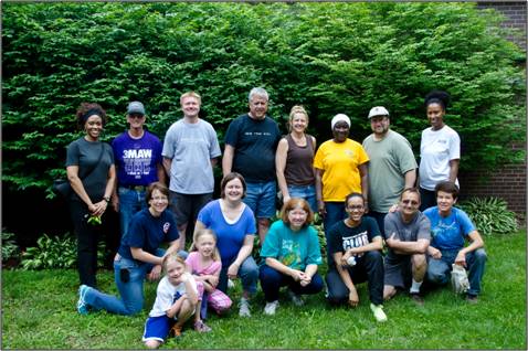
Each year EPA Region 7 staff come together to make a valuable impact in the community.  This special day is known as “Day of Caring.”  This year marked the 19th annual Day of Caring which took place on Saturday, June 1, 2013. Our volunteer team consisted of 17 people including staff, spouses and kids.

doc1

(Back Row, left-to-right): Toni Castro, Bob Wilson, Chris Lubbe, Dan Garvey, Jan Simpson, Fatimou Ndiaye, Marcus Rivas, LaTonya Sanders
(Front Row, left-to-right): Mary Peterson, Wendy Lubbe, Colleen Wilson, Shanice Castro, Steve Herndon, Kerry Herndon
Not Pictured: Karen Garvey, Jim Stevens, Paige Stevens
Special volunteers were the Lubbe twins, Caroline and Rose (pictured on front row)


Coordinated by the Heart of America United Way and the Heartland Combined Federal Campaign, Day of Caring is a community-wide service event that connects volunteers with nonprofit organizations to address social needs through special projects or events in the Kansas City metropolitan area.

EPA Region 7 has supported and participated in Day of Caring since the very beginning.  Each year, our staff look forward to spending a day together outside of the office, in the community, cleaning, painting, gardening, and helping with other projects at nonprofit organizations.  At the end of the day, it always feels great giving of ourselves to these organizations that make huge impacts in the communities that we live in and serve.

The EPA Region 7 team volunteered for Catholic Charities of Northeast Kansas at their Central Avenue facility in Kansas City, Kansas.  On the surface, we knew of some of the services and programs that Catholic Charities provided.  But, we learned so much more about the organization and their impact in the community, helping families and individuals in need, and their extensive programs to help refugees.  The EPA Region 7 volunteer team worked on five projects.

Bagging Canned Goods for Distribution 

Catholic Charities has several programs where they distribute donated food to homebound individuals.  Volunteers bagged canned goods for distribution.doc2

Restocking the Food Pantry

Catholic Charities has a food pantry where families and individuals in need can “shop” for grocery and personal items.  Volunteers restocked the shelves in the food pantry with donated items.

doc3

Organizing the Clothing Closet

Catholic Charities has a clothing closet where families and individuals in need can “shop” for clothing, shoes and other items.  Volunteers helped to sort and hang up clothes and organize the closet.

doc4

Beautification of the Garden

The Catholic Charities Central Avenue location has a beautiful garden and picnic area.  Volunteers helped to weed, clean up and plant flowers and shrubbery.

doc5

Grounds Cleanup

Volunteers helped to clean up around the parking area by weeding and raking leaves and debris.

doc6

Editor's Note: The opinions expressed herein are those of the author alone. EPA does not verify the accuracy or science of the contents of the blog, nor does EPA endorse the opinions or positions expressed. You may share this post. However, please do not change the title or the content. If you do make changes, please do not attribute the edited title or content to EPA or the author.

EPA's official web site is www.epa.gov. Some links on this page may redirect users from the EPA website to a non-EPA, third-party site. In doing so, EPA is directing you only to the specific content referenced at the time of publication, not to any other content that may appear on the same webpage or elsewhere on the third-party site, or be added at a later date.

EPA is providing this link for informational purposes only. EPA cannot attest to the accuracy of non-EPA information provided by any third-party sites or any other linked site. EPA does not endorse any non-government websites, companies, internet applications or any policies or information expressed therein.

EPA Region 7’s GIS VIP

By Shawn Henderson

After several attempts at college, including the part-time approach, I decided in the mid 2000’s to start taking full-time classes and finish up my degree.  I knew that I wanted computers to be my major, because I love technology, but I also had a strong affinity for geo-sciences.  Not knowing much about geographic information systems (GIS) at the time, it seemed to be the perfect mix of geography, geology, and computers and therefore tailored specifically to my interests.  I thought GIS was just going to be about map making, but I had a lot to learn.  I was in the first pure GIS class that my alma mater, Park University offered.  At the time there was no dedicated computer lab, and the text book was less than helpful, but it was interesting.  I remember that in the computer lab on the main floor of the science buildingpark there were only five computers with ArcGIS licenses; we had to fight other students who were working on reports in MS Word to get access to the software we needed.  Park’s Professor David Fox did the best with what resources were at his disposal, and he made the class really interesting and enjoyable.  I developed a good relationship with Dave.  One afternoon I was frustrated and fed up with the turn-over of professors in the Computer Science program back then, so I asked him if he would be my unofficial advisor. He agreed.  From then on, we were good.


One afternoon I had enough of my computer programming class and decided to go for a stroll to clear my mind.  I had been working on a user interface class but, the buttons and layout were not lining up. I wanted to throw the computer across the room.  I walked over by the library and found an advertisement for an EPA summer intern program.  At this point I had applied for a dozen internships and I chuckled to myself that I had absolutely no chance, but I also figured that I had nothing to lose.  It just so happened that I had a certification in MS Access, and a group at EPA was looking for an intern to develop a tracking database in Access.  I applied, the stars aligned, and I was accepted for the internship.


I quickly finished the tracking database, and I was able to detail into the Region’s GIS group and onto our Aqua Team with fellow colleagues like Roberta Vogel-Leutung and Laura Webb.  I transitioned into the Student Career Employment Program and was offered a full time position with the Agency after I graduated.  Sometime after that, my supervisor and I were brainstorming about GIS and we wondered if we could leverage my knowledge of Park’s program (which requires an internship) to offer their students a more robust GIS experience at EPA.   I approached Dave Fox with the idea, and he thought it was a fantastic approach.   Thus was born our GIS VIP (VOLUNTARY INTERNSHIP with PARK).  From there our program has blossomed with more than 15 students working on EPA GIS projects.


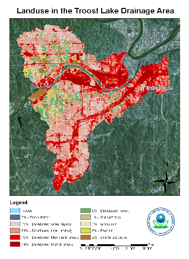
Map completed by Park Intern

Map completed by Park Intern

The experience of working with these students has been amazing!  There has been a variety of unique personalities come through the door.  I have had students that were worried and timid at the beginning, but by the end they were confidant and ready to save the world with GIS.  I’ve also had students come through to find out how much database/computer work is involved and realize that the real world experience of GIS isn’t something they want to head towards as a career goal.  In the end, not all the projects end up like we planned, but the experience the students and EPA staff get from these projects is invaluable.  Students have had the opportunity to work with EPA staff which provides them with professional experience and contacts.  In return the Agency gets a fresh look on things with young enthusiastic students and volunteer assistance on projects of substance.

Besides our work with Park, the Agency has several other voluntary opportunities.  Currently EPA Region 7’s Office of Public Affairs, is seeking a volunteer intern to work on social media coordination who is motivated, hard-working, and interested in helping the EPA protect human health and the environment.   You can find out all the details here.  Additionally our Superfund program is seeking two volunteer interns to work on separate projects found here and here.  These are great opportunities to build skills and your resume.  Heck my old boss  Jeffery Robichaud, also a fellow blogger, did his own volunteer internship with EPA in Philadelphia 20 years ago.

Shawn Henderson is an Environmental Protection Specialist with the Environmental Assessment and Monitoring Branch of the Environmental Services Division. He is a part of the Aqua Team, and conducts water quality sampling around the Region’s four states.  He has a Computer Science degree from Park University and helped to develop the Region’s KCWaterBug app and kcwaters.org.


Editor's Note: The opinions expressed herein are those of the author alone. EPA does not verify the accuracy or science of the contents of the blog, nor does EPA endorse the opinions or positions expressed. You may share this post. However, please do not change the title or the content. If you do make changes, please do not attribute the edited title or content to EPA or the author.

EPA's official web site is www.epa.gov. Some links on this page may redirect users from the EPA website to a non-EPA, third-party site. In doing so, EPA is directing you only to the specific content referenced at the time of publication, not to any other content that may appear on the same webpage or elsewhere on the third-party site, or be added at a later date.

EPA is providing this link for informational purposes only. EPA cannot attest to the accuracy of non-EPA information provided by any third-party sites or any other linked site. EPA does not endorse any non-government websites, companies, internet applications or any policies or information expressed therein.