 Navy Live The Official Blog of the U.S. Navy

By Rear Adm. Tim Gallaudet
Oceanographer of the Navy
Commander, Naval Meteorology and Oceanography Command
In the wake of multiple news reports about U.S. Navy ocean gliders, there have been numerous questions about these instruments and what they do for the U.S. Navy.
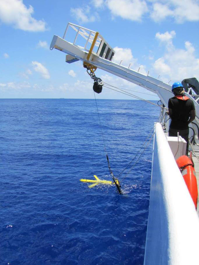
Ocean gliders are autonomous underwater vehicles used to collect oceanographic data in an effort to better understand the ocean. The gliders are made by Teledyne Webb and are sold commercially. The Navy uses the gliders to collect ocean temperature, salinity and depth information, and transmit the unclassified data to Naval Oceanographic Office (NAVOCEANO) for assimilation into NAVOCEANO’s operational ocean models. They are used by scientists and professionals around the world working in academia, the oil and gas industry as well as the military. Gliders have been the workhorses of the operational Naval Oceanography program for nearly two decades.
In 2004, I was on one of the Navy’s survey vessels for the first deployment of a glider from a Navy ship. Afterwards, the U.S. Navy established the Littoral Battlespace Sensing-Gliders (LBS-G) as a program of record in 2010 and has been using these gliders operationally since 2012. Each glider is modular in design and buoyancy-driven, allowing it to collect oceanographic data on water pressure, temperature, salinity in the water column for up to four months without the need for active propulsion.
I fund and direct the operations of this glider fleet from NAVOCEANO at Stennis Space Center, Mississippi. This fleet is the largest in the world, launched and recovered from six forward deployed military oceanographic survey vessels. NAVOCEANO’s scientists and Sailors conduct sea floor mapping from these ships to understand the undersea environment for military applications. Operations of the survey fleet is provided by the Military Sealift Command who own and operate the ships.
The gliders are piloted by personnel within NAVOCEANO’s Glider Operation Center (GOC) 24 hours a day, seven days a week at Stennis Space Center. In the event that the GOC loses contact with the instruments, they remain afloat in the ocean until located and recovered.
How do we use the data? NAVOCEANO uses the data collected for numerical modeling of ocean conditions. These models improve with glider data, which we share with regional partners to help their understanding of the environment.

Why does the Navy use gliders? Only 5 percent of the world’s oceans have been explored. These underwater robots allow us to explore more of the ocean, and faster, at a fraction of the cost of a manned submersible or a ship. The information gathered allows us to better predict ocean currents, density, sea states and tides which the U.S. Navy needs to safely and effectively operate all around the world. Once deployed, a glider can persistently sample the ocean for months freeing the ship to perform other functions.
I am extremely proud of our robust glider program. My goals for this program include expanding the current use of gliders, enabling the Fleet through the use of gliders and ocean models, and accelerating development and deployment of newer systems.
We have approximately 130 of these gliders and they are relatively inexpensive. The U.S. Navy will not only continue to use these technologies to improve our knowledge of the oceans, but we will be significantly increasing our use of gliders over the coming years so that our understanding of the ocean is the best in the world.
Comments

