As of September 1, 2014, the NOAAWatch website will be discontinued. Active weather alerts will continue to be available 24/7 at www.weather.gov. Hurricane tracking widgets will continue to be available at http://www.nhc.noaa.gov/widgets/nhc_widget.shtml and http://www.prh.noaa.gov/hnl/cphc/?widgets. Learn about ways to get updates through social media at http://www.noaa.gov/socialmedia/. For information about how to reach other NOAA data and information, please email NOAAWatch@noaa.gov. A temporary redirect of website traffic to NOAA’s homepage will exist for a short period of time after the shut-down of NOAAWatch.gov.
Mon, 22 Sep 2014 11:52:00 EDT
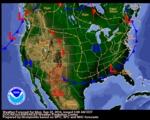
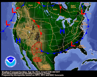
The weather pattern across the United States will be calming down a bit during the next few days from the very active regime of late. The heavy rainfall over the Southwest, largely fueled by the remnant moisture from long-since spun-down tropical cyclone Odile, is expected to slowly subside as a vigorous autumnal storm bears down on the Pacific Northwest. Most of the wind and precipitation with that cyclone should remain offshore during the next couple of days, but the upper-level jet stream associated with it will set fundamental changes into motion across much of the nation. Florida and the immediate southeastern Atlantic coast will be on the wet side as a wave of low pressure ripples along a stationary front just offshore. The Great Lakes, Ohio River valley, Northeast, and Mid-Atlantic states will experience a sharp cooldown in the wake of the two areas of low pressure crossing the Canadian Maritime provinces.
Latest local weather forecasts, warnings, watches, and advisories...
Hydrometeorological Prediction Center Short Range Forecast Discussion
National Hurricane Center Advisory

Mon, 22 Sep 2014 14:46:18 GMT
...POLO BECOMES A REMNANT LOW... ...THIS IS THE LAST ADVISORY...
As of 8:00 AM PDT Mon Sep 22
the center of POLO was located near 22.2, -114.4
with movement WSW at 7 mph.
The minimum central pressure was 1006 mb
with maximum sustained winds of about 30 mph.
Details...
Latest buoy reports


Fri, 06 Jun 2014 12:13:40 EDT
Coverage reached its year-to-date peak of 40.06% on May 6, but subsequent rainfall across portions of the nation’s mid-section has slightly reduced drought’s imprint. Nevertheless, drought still covers a substantial portion of the central and southern Plains and the western U.S.. On June 3, the highest level of drought—D4, or exceptional drought—was noted in portions of California (25%), Oklahoma (21%), Texas (9%), Nevada (8%), Kansas (2%), and Colorado (2%). California also led the nation with 77% coverage of extreme to exceptional drought (D3 to D4). In addition, California topped the U.S. with 70% of its rangeland and pastures rated in very poor to poor condition on June 1, according to USDA. Following California were New Mexico, Arizona, Kansas, Oklahoma, and Nevada.
Details...