Marine Navigation
Moving Safely Along our Marine Highways
Our marine transportation system includes 500,000 square nautical miles of navigationally significant waters. Over 1.34 billion metric tons of cargo, valued at $1.73 trillion, shipped in and out of U.S. ports in foreign trade in 2011. Those ports support, directly and indirectly, more than 13 million American jobs. The connections between the system, coastal communities, and maritime industries is intuitive. Less recognized are the links between communities in our nation's heartland and the marine transportation system. NOAA tools—such as nautical charts, accurate positioning services, and ocean and weather observations—play a key role in ensuring that shipments move swiftly and safely along our marine highways.


Nautical Charts
A nautical chart is one of the most fundamental tools available to the mariner. NOAA is the nation's chartmaker, constantly updating a suite of over 1,000 charts using sonar, LIDAR, and aerial photographs. Much like road maps, nautical charts provide basic navigation information, such as water depths and the locations of hazards.

Real-Time Data
NOAA delivers tools and information to help mariners safely navigate our nation's ports and harbors. For example, the Physical Oceanographic Real-Time System, or 'PORTS®,' operates in many ports around the country, providing up-to-the-minute information on tides, currents, salinity, water and air temperature, atmospheric pressure, and wind (speed, gusts, and direction).
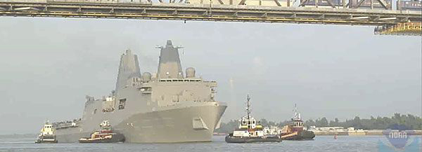
Spatial Framework
When a ship is passing under a bridge or moving through a channel, it can be a pretty tight fit. To avoid collisions and ensure safe passage, mariners rely on NOAA positioning information. NOAA's National Spatial Reference System and National Water Level Observation Network provide a highly accurate, precise, and consistent geographic reference framework throughout our country.

Marine Debris
You might not think of a floating plastic bag as something that keeps a ship from reaching its destination. However, marine debris, such as plastic bags, lost fishing nets, and other trash, can interfere with navigation safety. Marine debris can also harm shipping and coastal industries, clogging up and polluting waterways.


National Ocean Service | NOAA | Department of Commerce
Revised: November 14, 2016 | You are here: http://oceanservice.noaa.gov/navigation/marinenav/welcome.html