Connect
Stay informed and interact with the Developer Central community
News and Events
- DataLeague Open Data Hackathon @Maryland’s iSchool
- AT&T Government Solutions Hackathon – Washington, DC
- NDoCH 2016 Challenges Posted
- No upcoming events
View Calendar
*Events shown on our calendar are sponsored by a third party, not the Environmental Protection Agency (EPA). Views stated at this event are not endorsed by the EPA. EPA does not endorse any non-government organizations or events.
Build
Explore our most popular datasets and API's
Innovate
Below are a number of tools that have been developed using EPA's Data and API's
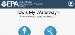
How’s My Waterway?
How’s My Waterway is a mobile-friendly website that helps people quickly find information, in plain-English, about the condition of their local waters on their smart phone, tablet, or desktop computer. Screen shots: Previous Slide Next slide Search using your location or by zipcode or address. Discover waterbodies in your area using the map view or […]
Read More ..
Nitrogen and Phosphorus Pollution Data Access Tool
This data access tool and data layers represent the best information currently available, and by making these data layers viewable and downloadable through this data access tool.
Read More ..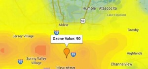
OzoneMap
OzoneMap provides a real-time ozone map that allows residents of the Houston, Texas region to make informed decisions about protecting their health by limiting personal exposure to unhealthy levels of ground level ozone.
Read More ..
Forecast Now
Forecast Now uses any user-entered town and state to provide you with the latest detailed local forecast, hazardous weather conditions, air quality index, radar images and satellite photo, direct from the US National Weather Service and the EPA.
Read More ..
ChesapeakeStat
A public website that promotes improved accountability, fosters coordination, and promotes transparency by sharing performance information on goals, indicators, strategies, and funding.
Read More ..
IFIS – Iowa Flood Information System
The Iowa Flood Information System (IFIS) is a web-based platform developed by Iowa Flood Center (IFC) to provide access to flood conditions, flood forecasts, flood related data, and information and interactive visualizations for communities in Iowa.
Read More ..Explore Project Ideas