National dataset consisting of a snapshot of 303(d) Listed Impaired Waters combined with Impaired Waters with TMDLs whose parent cause is Nutrients, Sediments, and Pathogens. The snapshot constitutes the top water impairments. The Impaired Waters with TMDLs and the 303(d) Listed Impaired Waters are combined into three mapping service layers in MyWaters Mapper application to […]
Tag: EPA.
GRTS locational data for nonpoint source projects. GRTS locations are coded onto NHDPlus v2.1 flowline features to create point and line events or coded onto NHDPlus v2.1 waterbody features to create area events. In addition to NHDPlus reach indexed data there may also be custom events (point, line or area) that are not associated with […]
The 303(d) Listed Impaired Waters program system provides impaired water data and impaired water features reflecting river segments, lakes, and estuaries designated under Section 303(d) of the Clean Water Act. Each State will establish Total Maximum Daily Loads (TMDLs) for these waters. Note the CWA Section 303(d) list of impaired waters does not represent waters […]
The 305(b) program system provide assessed water data and assessed water features for river segments, lakes, and estuaries designated under Section 305(b) of the Clean Water Act. 305(b) waterbodies are coded onto NHDPlus v2.1 features creating area, point and linear events representing assessed and non-assessed waters. In addition to NHDPlus reach indexed data there may […]

Home builders and verifier partners in the field at new home construction sites have easy access to the tools and resources of EPA’s Indoor airPLUS program. Builders and Raters can use the app to review the Indoor airPLUS Construction Specifications and complete and email the Verification Checklist from the field. Homeowners can use the app […]
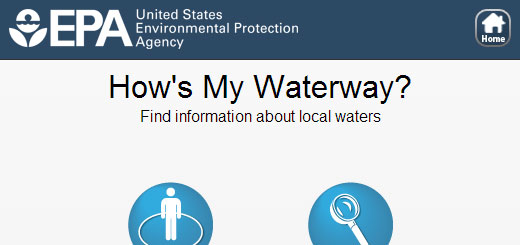
How’s My Waterway is a mobile-friendly website that helps people quickly find information, in plain-English, about the condition of their local waters on their smart phone, tablet, or desktop computer. Screen shots: Previous Slide Next slide Search using your location or by zipcode or address. Discover waterbodies in your area using the map view or […]

This data access tool and data layers represent the best information currently available, and by making these data layers viewable and downloadable through this data access tool.

The AIRNow mobile application provides you real-time air quality information that you can use to protect your health when planning your day. You can get location-specific reports on current air quality and air quality forecasts for both ozone and fine particle pollution (PM2.5). Air quality maps from the AIRNow website provide visual depictions of current […]
New Features Added! New MyClimate section for MyE – In response to the FY2008 Consolidated Appropriations Act (H.R. 2764; Public Law 110–161), EPA launched the Greenhouse Gas Reporting Program (GHGRP). The program requires annual reporting of greenhouse gas (GHG) data and other relevant information from large direct emissions sources and suppliers of certain fossil fuels […]

Find repellent products that work against mosquitos, ticks, or both.