All Images
-
Perhaps the most impressive of cloud formations, cumulonimbus (from the Latin for “pile” and “rain cloud”) clouds form due to vigorous convection (rising and overturning) of warm, moist and unstable air. Surface air is warmed by the sun-heated ground surface and rises; if sufficient atmospheric moisture is present, water droplets will condense as the air mass encounters cooler air at higher altitudes. The air mass itself also expands and cools as it rises due to decreasing atmospheric pressure, a process known as adiabatic cooling. This type of convection is common in tropical latitudes year-round and during the summer season at higher latitudes.
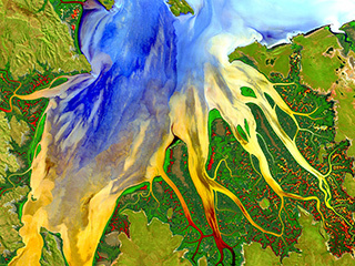
As water in the rising air mass condenses and changes from a gas to a liquid state, it releases energy to its surroundings, further heating the surrounding air and leading to more convection and rising of the cloud mass to higher altitudes. This leads to the characteristic vertical “towers” associated with cumulonimbus clouds, an excellent example of which is visible in this astronaut photograph. If enough moisture is present to condense and heat the cloud mass through several convective cycles, a tower can rise to altitudes of approximately 10 kilometers at high latitudes and to 20 kilometers in the tropics before encountering a region of the atmosphere known as the tropopause—the boundary between the troposphere and the stratosphere.
The tropopause is characterized by a strong temperature inversion. Beyond the tropopause, the air no longer gets colder as altitude increases. The tropopause halts further upward motion of the cloud mass. The cloud tops flatten and spread into an anvil shape, as illustrated by this astronaut photograph. The photo was taken from a viewpoint that was at an angle from the vertical, rather than looking straight down towards the Earth’s surface. The image, taken while the International Space Station was located over western Africa near the Senegal-Mali border, shows a fully formed anvil cloud with numerous smaller cumulonimbus towers rising near it. The high energy levels of these storm systems typically make them hazardous due to associated heavy precipitation, lightning, high wind speeds and possible tornadoes.


Cumulonimbus cloud over Africa
Cumulonimbus cloud over Africa -
The Sierra de Velasco Mountains dominate this image in northern Argentina. The Catamarca province is in the northern part of the image, and the La Rioja province is to the south. The streams are fed by runoff from the snow in the Andes Mountains to the north. These intermittent streams can dry up rapidly. The larger urban area near the bottom of the image is La Rioja, the capital of the province of La Rioja.
This image was acquired by the Landsat 5 satellite on February 28, 1985.

Argentina
Argentina -
This image shows a spinning formation of ice, clouds and low-lying fog off the eastern coast of Greenland.
This image was acquired by the Landsat 7 satellite on May 14, 2001. This is a false-color composite image made using infrared, red and green wavelengths.

Whirlpool
Whirlpool -
Nicknamed “Dragon Lake,” this body of water is formed by the Bratskove Reservoir, built along the Angara River in southern Siberia, near the city of Bratsk. This image was acquired in winter, when the lake is frozen.
This image was acquired by the Landsat satellite on December 19, 1999. This is a natural color composite image made using blue, green and red wavelengths.

Dragon Lake, Siberia
Dragon Lake, Siberia -
Brazil’s Araca River is a tributary of the Negro River, which feeds into the Amazon.
This image was acquired by the Landsat 7 satellite on March 15, 2000. This is a false-color composite image made using shortwave infrared, near infrared, and green wavelengths. The image has also been sharpened using the sensor’s panchromatic band.

Araca River
Araca River -
These are the Anti-Atlas Mountains, part of the Atlas Mountain range in southern Morocco, Africa. The region contains some of the world’s largest and most diverse mineral resources, most of which are still untouched.
This image was acquired by the Landsat 7 satellite on June 22, 2001. This is a false-color composite image made using shortwave infrared, infrared and red wavelengths.

Atlas Mountains
Atlas Mountains -
These cloud formations were seen over the western Aleutian Islands. Their color variations are probably due to differences in temperature and in the size of water droplets that make up the clouds.
This image was acquired by the Landsat 7 satellite on June 16, 2000.

Aleutian clouds
Aleutian clouds -
This scar on an arid landscape is the dry riverbed of the Ghadamis River in the Tinrhert Hamada Mountains near Ghadamis, Libya.
This image was acquired by the Landsat 7 satellite on November 6, 2000. This is a false-color composite image made using near-infrared, green, and blue wavelengths. The image has also been sharpened using the sensor’s panchromatic band.

Ghadamis River in Libya
Ghadamis River in Libya -
Along Greenland's western coast, a small field of glaciers surrounds Baffin Bay.
This image was acquired by the Landsat 7 satellite on September 3, 2000. It is a false-color composite image made using near-infrared, red and blue wavelengths.

Baffin Bay, Greenland
Baffin Bay, Greenland -
The Ganges River forms an extensive delta where it empties into the Bay of Bengal. The delta, largely covered with a swamp forest, is home to most of Bangladesh, one of the world’s most densely populated countries and a nation that is particularly vulnerable to climate change. As the climate changes, low-lying Bangladesh will increasingly face issues such as food insecurity, sea level rise and more frequent and intense extreme weather events. About 120 million people live on the Ganges Delta under the threat of repeated catastrophic floods due to heavy runoff of meltwater from the Himalayas and due to the intense rainfall during the monsoon season.
This image was acquired by the Landsat 7 satellite on February 28, 2000. It is a false-color composite image made using green, infrared, and blue wavelengths.

Ganges River Delta
Ganges River Delta -
A series of rocky outcroppings are a prominent feature of this Sahara Desert landscape near the Terkezi Oasis in the country of Chad.
This image was taken by the Landsat 7 satellite on October 22, 2000. It is a false-color composite image made using near infrared, green, and red wavelengths. The image has also been sharpened using the sensor's panchromatic band.

Terkezi Oasis
Terkezi Oasis -
Ephemeral Lake Carnegie, in Western Australia, fills with water only during periods of significant rainfall. In dry years, it is reduced to a muddy marsh.
This image was acquired by the Landsat 7 satellite on May 19, 1999. This is a false-color composite image made using shortwave infrared, infrared and red wavelengths. The image has also been sharpened using the sensor's panchromatic band.

Lake Carnegie
Lake Carnegie -
The Dasht-e Kevir, or Great Salt Desert, is the largest desert in Iran. It is primarily uninhabited wasteland, composed of mud and salt marshes covered with crusts of salt that protect the meager moisture from completely evaporating.
This image was taken by the Landsat 7 satellite on October 24, 2000. It is a false-color composite image made using infrared, green and red wavelengths. The image has also been sharpened using the sensor’s panchromatic band.

Great Salt Desert, Iran
Great Salt Desert, Iran -
This interesting image shows the world’s largest glacier, Lambert Glacier in Antarctica, and icefall that flows into it. Ice flows like water, albeit much more slowly. Cracks can be seen in this icefall as it bends and twists on its slow descent 1300 feet (400 meters) to the glacier below. The image was taken by the Landsat-7 satellite on December 2, 2000 and is a false-color composite made from infrared, red and green wavelengths. The image has also been sharpened using the sensor’s panchromatic band.

Icefall
Icefall -
This false-color image shows snow-capped peaks and ridges of the eastern Himalayas between major rivers in southwest China. The Himalayas are made up of three parallel mountain ranges that together stretch for more than 1800 miles (2,900 kilometers). This particular image was taken by NASA’s Advanced Spaceborne Thermal Emission and Reflection Radiometer (ASTER), flying aboard the Terra satellite, on February 27, 2002. The picture is a composite made by combining near-infrared, red and green wavelengths.

The Himalayas
The Himalayas -
This photo, taken on January 22, 2001 by the Landsat-7 satellite, shows Akpatok Island, which lies in Ungava Bay in Canada. Accessible only by air, Akpatok Island rises out of the water as sheer cliffs that soar 500 to 800 feet (150 to 243 meters) above the sea surface. The island is an important sanctuary for cliff-nesting seabirds. Numerous ice floes around the island attract walruses and whales, making Akpatok a traditional hunting ground for native Inuit people.

Akpatok Island
Akpatok Island -
This image, captured by the Landsat-8 satellite, shows the view over Western Australia on May 12, 2013. The image shows rich sediment and nutrient patterns in a tropical estuary area and complex patterns and conditions in vegetated areas.
The image is enhanced and involved masking, separately enhancing and then reassembling water and land portions of the image. The water patterns are the result of an RGB display of Landsat-8’s red, blue, and ultra-blue bands. Land is shown using short-wavelength-infrared, near-infrared and green.
Color explosion
Color explosion -
This photo from NASA’s Curiosity rover shows the Earth as seen from the surface of Mars, shining brighter than any star in the Martian night sky. Earth is the bright point of light a little left of the image’s center and our moon can be seen just below Earth. Curiosity, which landed on the red planet on August 6, 2013, is the largest and most advanced rover ever sent to Mars. It studies the geology of its surroundings and has found evidence of a past environment well-suited to support microbial life.
Researchers used the left-eye camera of Curiosity's Mast Camera (Mastcam) to capture this scene about 80 minutes after sunset on the 529th Martian day, or sol, of the rover's work on Mars (January 31, 2014). The image has been processed to remove cosmic-ray effects. A human observer with normal vision, if standing on Mars, could easily see Earth and the moon as two distinct bright evening ‘stars’. When Curiosity took the photo, Earth was about 99 million miles (160 million kilometers) from Mars.
This picture adds to our collection of photos of planet Earth from afar, giving a unique perspective to our place in the cosmos.

Earth from Mars
Earth from Mars -
This beautiful aerial photograph shows a multi-layered lenticular cloud hovering near Mount Discovery in Antarctica, a volcano about 70 kilometers (44 miles) southwest of McMurdo. The shot was taken by scientist Michael Studinger on November 24, 2013 as he was flying over the area as part of NASA’s Operation IceBridge campaign. IceBridge is an airplane-based mission to fly over Antarctica and the Arctic, monitoring conditions there until NASA’s new ice-watching satellite, ICESat-2, launches in 2016. ICESat-1 was decommissioned in 2009 and IceBridge aircraft have been flying ever since, maintaining NASA's eyes on the ice.

Antarctic wonders
Antarctic wonders -
The sun sets over NASA's Kennedy Space Center in Florida, on October 13, 2010.

Vivid sunset
Vivid sunset -
This map shows the bright lights of cities and wildfires set against the inky black backdrop of night. The image is actually a composite of satellite data collected over a number of days in April 2012 and October 2012, and is the result of 312 orbits and 2.5 TB of information. The lights seen here are not just from cities; they are also from wildifires, lightning, gas flares and reflected moonlight. Because the image is a composite of several days’ worth of data, fires and other points of light may have been picked up by the satellite and integrated into the composite image even though they were temporary, making some rural locations (such as in Australia) seem brighter than they really are on a typical day.

Night lights, big cities
Night lights, big cities -
This iconic image speaks volumes. To many it underscores the vastness of space, the loneliness of the cosmos and how fragile our home planet really is. Entitled “Earthrise,” it was taken by astronaut William Anders during an orbit of the moon as part of the Apollo 8 mission.
Apollo 8 was the first manned mission to the moon, which entered the Moon’s orbit on Christmas Eve 1968. That evening, the astronauts onboard held a live broadcast, in which they showed pictures of the Earth and moon as seen from their spacecraft. Command Module Pilot Jim Lovell said, "The vast loneliness is awe-inspiring and it makes you realize just what you have back there on Earth." The astronauts ended the broadcast with the crew taking turns reading from the book of Genesis.

Image: Earthrise
Image: Earthrise -
In this image, it’s hard to get a sense of scale or of what we’re actually looking at. This picture, taken by the Landsat-5 satellite on 8 April, 1985, shows sand dunes (yellow streaks) that extend from Algeria into Mauritania in northwest Africa. These wind-blown sand ridges make up Erg Iguidi, one of the Sahara’s ‘sand seas’ in which individual dunes are often more than a third of a mile (500 meters) wide and tall.

Sea of sand
Sea of sand -
This image, taken on 10 May 2001, shows one of the islands of New Caledonia, an archipelago 1200 kilometers (750 miles) east of Australia. New Caledonia contains the world’s third-largest coral reef structure, and its coral reefs support an unusually large diversity of species, including many predators, big fish, turtles, and the world’s third-largest dugong population. (Dugongs are large marine mammals.) In this natural-color image, the islands appear in shades of green and brown — mixtures of vegetation and bare ground. The surrounding waters range from pale aquamarine to deep blue, and the color differences reflect varying water depths. Over coral reef ridges and sand bars, the water is shallowest and palest in color.

Blue lagoon
Blue lagoon -
This photo, taken on 30 December 2010, shows the aft section of the International Space Station (ISS). It was taken by an Expedition 26 crew member from a window in the ISS Progress 40 supply vehicle docked to the Pirs Docking Compartment.

Aft view of Earth
Aft view of Earth


