

Atlantic Sea Scallop (Placopecten magellanicus)
Atlantic Sea Scallop
Implementing regulations are found at 50 CFR Part 648 Subpart D.
The Atlantic sea scallop is one of the most valuable fisheries in the United States. The primary range for the Atlantic sea scallop fishery is along the Atlantic coast from the Mid-Atlantic to the US/Canada border. The scallop fishery uses predominantly paired or single scallop dredges throughout the entire range of the fishery. To a lesser extent, and mainly in the Mid-Atlantic region, the scallop fishery uses trawl gear. Most vessels land Atlantic sea scallops as shucked meats (the adductor muscle) but some vessels also land whole (in-shell) scallops.
New! Check out the Story Map interactive website to see an overview of the 2016 scallop regulations.
2016 Scallop Bulletins
- 11/04/2016
- Commercial Fishing Prohibited in National Monument
- 11/02/2016
- Atlantic Sea Scallop Amendment 19 Approved - New Start Date for the Scallop Fishing Year and New Specifications Process
- 09/20/2016
- Industry-Funded Monitoring Ominbus Amendment, Public Hearings and Comment Period
- 06/30/2016
- Closure of the Mid-Atlantic Scallop Access Area for the Limited Access General Category Individual Fishing Quota Fleet; Effective Date: July 04, 2016
- 06/14/2016
- Closure of the Nantucket Lightship North Scallop Access Area for the Limited Access General Category Individual Fishing Quota Fleet; Effective Date: June 16, 2016
- 05/11/2016
- Atlantic Sea Scallop Fishery; Closure of the Northern Gulf of Maine Scallop Management Area; Effective May 13, 2016
- 05/03/2016
- Atlantic Sea Scallop Vessels (Limited Access General Category); Updated Allocations for the Remainder of the 2016 Fishing Year and Other New Measures
- 05/03/2016
- Atlantic Sea Scallop Vessels (Limited Access); Updated Allocations for the Remainder of the 2016 Fishing Year and Other New Measures
- 04/20/2016
- Reminder for DAS Credits and Fishing Year 2016 Observer Set-Aside Compensation Rates
- 02/09/2016
- Atlantic Sea Scallop Fishery Management Measures for Fishing Year 2016 - Effective March 1, 2016
- 01/13/2016
- 2016 Vessel Permit Renewal Bulletin
Click Below for Past Bulletins (Permit Holder Letters):
2016 Scallop Federal Register Actions
- 11/02/2016
- Final Rule; Atlantic Sea Scallop Fishery; Amendment 19
- 09/23/2016
- Draft Omnibus Industry-Funded Monitoring Amendment and Draft Environmental Assessment Available for Public Comment
- 09/19/2016
- Notice of Public Hearings; Request for Comments; Fisheries of the Northeastern United States: Omnibus Amendment Public Hearings
- 08/15/2016
- Proposed rule; request for comments; Atlantic Sea Scallop Fishery; Amendment 19
- 07/19/2016
- Notice of availability of fishery management plan amendment; request for comments; Amendment 19 to the Atlantic Sea Scallop Fishery Management Plan
- 06/30/2016
- Temporary Rule; Closure; Atlantic Sea Scallop Fishery: Closure of the Mid-Atlantic Access Area to General Category Individual Fishing Quota Scallop Vessels
- 06/14/2016
- Temporary rule; closure; Atlantic Sea Scallop Fishery; Closure of the Nantucket Lightship North Access Area to General Category Individual Fishing Quota Scallop Vessels
- 05/25/2016
- Notice; Request for Comments; Application for Exempted Fishing Permits; Box Dredge EFP
- 05/25/2016
- Notice With Request for Comments; Northeast Ocean Plan
- 05/11/2016
- Temporary Rule; Atlantic Sea Scallop Fishery; 2016 Closure of the Northern Gulf of Maine Scallop Management Area
- 05/04/2016
- Notice; Request For Comments; Application for Exempted Fishing Permits; DA16-024 CFF Georges Bank Optimization Study EFP
- 05/03/2016
- Final Rule: Atlantic Sea Scallop Fishery; Framework Adjustment 27
- 04/12/2016
- Notice; Request For Comments; Application for Exempted Fishing Permits; CFF Compensation Fishing Gear Research EFP
- 04/05/2016
- Notice; Request For Comments; General Provisions for Domestic Fisheries; Application for Exempted Fishing Permits; CFF LAGC Modified Sweep EFP
- 04/05/2016
- Notice; Request For Comments; General Provisions for Domestic Fisheries; Application for Exempted Fishing Permits; DA16-013 NFI Incidental Discard Mortality EFP
- 03/18/2016
- Temporary Rule; Northeast Multispecies Fishery; Adjustment of Georges Bank and Southern New England/Mid-Atlantic Yellowtail Flounder Annual Catch Limits
- 02/25/2016
- Notice; Request For Comments; General Provisions for Domestic Fisheries; Application for Exempted Fishing Permits; DA15-084 CFF Resource Enhancement Study EFP
- 02/23/2016
- Proposed Rule; Atlantic Sea Scallop Fishery; Framework Adjustment 27
Click Below for Past Federal Register Actions & Public Comments:
| 2015 | 2014 | 2013 | 2012 | 2011 | 2010 | 2009 | 2008 | 2007 | 2006 | 2005 | 2004 | 2003 | 2002 | 2001 | 2000 |
Scallop Feature Stories
- Sea Scallop Research Set-Aside Awards Announced - We are pleased to announce that 15 research projects have been selected for support from the 2016 Sea Scallop Research Set-Aside (RSA) program.
General Fisheries Information Sheets
- Gear Stowage Requirements
- Letters of Authorization
- Small Mesh Fishery Exemptions
- Large Mesh Fishery Exemptions
Sea Scallops
Current Electronic Code of Federal Regulations (e-CFR)
What are other common names for the Atlantic sea scallop? Scallop, Sea scallop, and Giant scallop.
When does the fishery occur? The fishery occurs year-round.
Where does the fishery occur? The primary range for the Atlantic sea scallop fishery is along the Atlantic coast from the Mid-Atlantic to the US/Canada border. Scallops are found mainly on sand and gravel sediments where bottom temperatures remain below 20ᵒC (68ᵒF).
What depths are Atlantic sea scallop found? North of Cape Cod, concentrations generally occur in shallow water less than 40 m (22 fathoms) deep. South of Cape Cod and on Georges Bank, sea scallops typically occur at depths between 25 and 200 m (14 to 110 fathoms), with commercial concentrations generally between 35 and 100 m (19 to 55 fathoms).
What other species are caught with Atlantic sea scallops? Finfish (such as yellowtail flounder, windowpane flounder, skates, and monkfish), sea turtles, and undersized scallops can be incidentally caught in the scallop fishery.
What gear types are authorized and what gears are primarily used? The scallop fishery uses predominantly paired or single scallop dredges throughout the entire range of the fishery. To a lesser extent, and mainly in the Mid-Atlantic region, the scallop fishery uses trawl gear.How is the fishery managed? The Atlantic sea scallop fishery consists of two primary fleets, the Limited Access (LA) fleet, and the Limited Access General Category (LAGC) fleet.
The LA fleet is managed with days-at-sea (DAS) – a number of days that can be fished per year –and an access area rotation program. The New England Fishery Management Council (NEFMC ) established the access area rotational program to promote optimal yield in the fishery. Under the rotation program, the Council closes areas with large concentrations of fast-growing, small scallops before the scallops are exposed to fishing. Scallops grow fastest when they are very small and protection of these small scallops through area closures is critical in the rotational management of the scallop resource. After a period of closure, and after evaluation according to the criteria and procedures established in the Fishery Management Plan (FMP), the areas will re-open for scallop fishing, when the scallops are larger and more suitable for harvest. This process boosts scallop meat yield and yield per recruit. When the areas are open for access (i.e., “access areas”), vessels are allocated a number of trips with corresponding trip limits that they may use in those dedicated access areas. Once the high concentrations of scallops in an access area have been fished down, the Council may decide to close the area again if it appears that the resource will rebound in a few years after protecting any small scallops that may be there, or the Council could convert the area back to an “open area”. Open areas are where LA vessels fish for scallops under DAS allocations.
The primary component of the LAGC fleet is vessels with Individual Fishing Quotas (IFQ). These vessels are allocated a yearly IFQ allocation which may be leased or permanently transferred among the IFQ fleet and may be fished throughout the fishing year (FY). Although IFQ vessels are allocated a number of fleet-wide trips into the scallop access areas (landings from these trips are still applied against their IFQ allocations), most of the scallop fishing by LAGC IFQ vessels occurs in open areas.
LAGC IFQ vessels are required to fish in specific exemption areas within the open areas. These areas are the Gulf of Maine, Southern New England, and Great South Channel Scallop Dredge Exemption Areas, and the Mid-Atlantic Exemption Area.
Who manages this fishery? The NEFMC and NOAA Fisheries Service (NMFS) manage the scallop fishery in Federal waters. Please see the Council’s website and our Announcements page for information on past and present scallop related management actions.
What is the fishing year for this fishery? The scallop fishery operates year-round. The fishing year for management measures is March 1 to February 28.
What are the different management areas for the Atlantic sea scallop fishery? The LA fishery is managed by open and access areas, and the IFQ as described above. The Northern Gulf of Maine management area is managed separately from the rest of the Atlantic sea scallop stock. Refer to the Areas tab for a chart of the various management areas.
1982 – Atlantic Sea Scallop Fishery Management Plan implemented, requiring that harvestable scallops meet a minimum weight requirement
1994 – NOAA Fisheries Service closes areas on Georges Bank and Nantucket shoals to groundfish and scallop fishing
1994 – Moratorium on scallop permits implemented; limits on "days-at-sea" to reduce fishing effort and a limit on crew size are initiated; protocol for collecting commercial fishing data for Northeast U.S. fisheries is changed; increase in dredge ring size from 3.0 to 3.5 inches is required by 1996; open access "general category" scallop permits created to allow small-scale scalloping and incidental catch of scallops in other fisheries
1997 – Scallops are declared overfished
1998 – More stringent "days-at-sea" limitation and a plan to rebuild stocks within 10 years are established; maximum crew size capped at seven; vessel monitoring systems are required on limited access scallop vessels
1998-2001 – Managers close extensive areas in Mid-Atlantic Bight region to scallop fishing
1999-2001 – First limited re-openings of closed area on Georges Bank
2001 – Mid-Atlantic biomass continues to increase as a result of above-average recruitment coupled with better size selection by the fishery and gear; Mid-Atlantic areas closed since 1998 reopen to controlled fishing
2004 – "Area rotation management program" implemented (rotating open and closed areas to maximize scallop yield); a new rotational area (the "Elephant Trunk" area) is closed to fishing for 3 years; dredge ring size is further increased to 4 inches; minimum mesh size for mesh on top of the dredge gear set at 10 inches to reduce flounder bycatch
2004 – Biomass peaks
2004-2006 – Limited portions of Georges Bank closed areas reopen to controlled fishing
2005 – Vessel monitoring systems required on open access general category vessels
2006 – Chain mats required in sea scallop dredges used in the Mid-Atlantic, May through November, to prevent sea turtles from entering gear
2007 – Industry-funded observer program continued through a total allowable catch and days-at-sea set-aside program to help vessel owners defray the cost of carrying observers (program is necessary to monitor bycatch of finfish and interactions with threatened and endangered species)
2007 – Elephant Trunk area reopens to fishing; a new rotational closure (Delmarva) is implemented
2008 – Limited access and individual quotas established for the general category fleet of scallop vessels; other important measures established to control fishing mortality and capacity in the general category scallop fishery
2008 – Researchers find high number of small seed scallops, or recruits, in the Great South Channel of Georges Bank and in other survey areas; numbers are the highest seen on Georges Bank since 2000 and the second highest in the Mid-Atlantic Bight since 1979, documenting the effectiveness of management rotating commercial fishery access to highly productive sea scallop areas while closing other areas to allow sea scallops to grow; very encouraging news for both the resource and the fishery during the next few years
2008 – The limited access general category (LAGC) scallop fishery is created and there is no longer an open access scallop permit. There are three categories of LAGC permits: Individual fishing quota (IFQ) permits, Northern Gulf of Maine (NGOM) permits, and incidental permits.
2010 – All IFQ permit appeals are completed; the IFQ program begins
2011 –Annual catch limit and accountability measure (AM) requirements of the Magnuson-Stevens Fishery Conservation and Management Act are implemented, including a sub-ACL and AM for yellowtail flounder caught in the scallop fishery; scallop EFH closed areas are modified to be consistent with areas closed for EFH in the Groundfish FMP
2012 – The Turtle Deflector Dredge (TDD) is approved (implemented in May 2013) and modifications to the yellowtail flounder AMs were implemented
2013 – The yellowtail flounder AMs are expanded to include LAGC IFQ vessels; the observer set-aside program is also expanded to include LAGC IFQ vessels fishing in open areas; the Georges Bank access area seasonal closures in Closed Area 1 and Nantucket Lightship Access Areas were removed, and the Closed Area 2 Access Area seasonal closure was modified
2014 – The Council developed windowpane flounder AMs for the Southern New England/Mid-Atlantic Region.
What are the primary markets for the scallop fishery? Sea scallops are primarily landed as shucked meats which are graded by the number of meats per pound. Example: 20-30, 10-20, or U10 (less than 10 meats per pound). There is also a limited market for live, unshucked scallops.
What are the current landings and value of the scallop fishery? The Atlantic sea scallop fishery is the largest and most valuable wild scallop fishery in the world. In 2012, U.S. fishermen harvested 56 million pounds of sea scallop meats worth over $546 million. While the average price for scallop meats in 2012 was around $10 per pound, this average is highly variable due to both seasonal quality and the nature of the different fisheries.
What are the top scallop landing ports? Massachusetts and New Jersey are responsible for the majority of the U.S. harvest. The three primary ports in descending order of pounds landed (2011) are New Bedford, MA, Cape May, NJ, and Norfolk, VA.
Northeast Fisheries Science Center Scallop Information – click here
| Stock | Atlantic Sea Scallops |
| Overfishing? | No |
| Overfishing definition |
Stock Biomass ≥ BMSY: F exceeds FMSY, which is currently estimated at 0.38 Stock Biomass ≤ BMSY: When F exceeds the level that has a 50-percent probability to rebuild stock biomass to BMSY in 10 years |
| Overfished? | No |
| Overfished definition |
Stock Biomass ≥ BMSY: When total stock biomass is less than 1/2 BMSY Stock Biomass ≥ BMSY: When F is above a level expected to rebuild in 5 years, or above zero when the stock is below 1⁄4 BMSY |
| Rebuilding Program Progress | No Rebuilding Program (rebuilt) |
| F/FMSY | 0.48 |
| Fishing Mortality Rate (F) | 0.32 |
| B/BMSY | 96,480 mt |
| Biomass (B) | 132,561 mt |
Most Recent Environmental Impact Statement (EIS): Amendment 15, submitted in January 2011.
Most Recent Biological Opinion: July 2012.
Most Recent Stock Assessment: The SAW 59 assessment conducted in 2013.
Next Stock Assessment: TBD
Quota Monitoring – click here
FY 2016 Scallop Fishery Allocations
|
Overfishing Limit |
68,418 mt (150,835,870 lb) |
|
Annual Biological Catch/Annual Catch Limit (ABC/ACL) (Discards Removed) |
37,852 mt (83,449,375 lb) |
|
Incidental TAC |
23 mt (50,706 lb) |
|
Northern Gulf of Maine TAC |
31.8 mt (70,000 lb) |
|
Research Set-Aside |
567 mt (1,250,000 lb) |
|
Observer Set-aside (1 percent of ABC/ACL) |
379 mt (835,552 lb) |
|
Limited Access ACL (94.5 percent of total ACL, after deducting set-asides and incidental catch) |
34,855 mt (76,842,121 lb) |
|
Limited Access sub-Annual Catch Target (ACT) (adjusted for management uncertainty) |
18,290 mt (40,322,548 lb) |
|
Limited Access General Category ACL (5.0 percent of total ACL, after deducting set-asides and incidental catch) |
1,845 mt (4,067,529 lb) |
|
Limited Access General Category ACL for vessels with Limited Access scallop permits |
184 mt (405,651 lb) |
How often do the quotas change for this fishery? Annual or Biennially
What if specifications are not in place at the start of fishing year? Default specifications go into effect
What if specifications are not in place at the start of fishing year? Default specifications go into effect
Limited Access General Catagory (LAGC) Vessels
FY 2016 LAGC Fleet Allocations
|
LAGC IFQ only |
4,067,529 lb |
|
LAGC IFQ with LA permit |
405,651 lb |
|
LAGC NGOM Allocation |
70,000 lb |
|
LAGC Incidental Allocation |
50,000 lb |
Access Area Trips for LAGC IFQ vessels:
LAGC IFQ vessels are allocated a fleetwide number of trips into available access areas. Once the fleetwide total of trips has been taken, the area closes to IFQ vessels. The following table lists the number of trips the LAGC IFQ fleet can take in the individual access areas for FY 2016.
FY 2016 Access Area Trip Allocations for the LAGC IFQ Scallop Fleet
|
|
Closed Area I |
Closed Area II |
Nantucket Lightship |
Mid-Atlantic |
|
Trips |
0 |
0 |
485 |
2,068 |
Accountability Measures for the LAGC IFQ Fleet:
NMFS deducts IFQ from a vessel that exceeds its IFQ from its IFQ allocation in the following fishing year. The deduction includes any IFQ transferred from another IFQ vessel. The deduction will be equal to the amount landed in excess of the vessels IFQ, plus any transferred IFQ. The deduction would apply for multiple years if necessary to account for the overage with the IFQ. A vessel may also be subject to enforcement actions if it exceeds its IFQ in a given fishing year.
Atlantic Sea Scallop Individual Fishing Quota Cost Recovery Program
- 2013 Annual Report (May 2014)
Limited Access (LA) Vessels
Access Area Trips for LA vessels:
- Full-time vessels are allocated 51,000 lb of access area scallops in the Mid-Atlantic Access Area for FY 2016. The vessel can take as many or as few trips as needed, so long as the trip does not exceed the 17,000-lb possession limit on any one trip.
- Part-time vessels are allocated 20,400 lb of access area scallops in the Mid-Atlantic Access Area for FY 2016. The vessel can take as many or as few trips as needed, so long as the trip does not exceed the 10,200-lb possession limit on any one trip.
Access Area Seasons:
For FY 2016 all three Mid-Atlantic Access Areas, with the exception of the Elephant Trunk Closure Area mentioned below, are treated as a single access area. Vessels can cross all three areas (Delmarva, Elephant Truck, and Hudson Canyon) on a single access area trip.
A 549 square mile area in the northwest corner of the Elephant Trunk Access Area is closed to scallop fishing. Note: Vessels are prohibited from transiting the Elephant Trunk Closed area when on a declared scallop trip (please refer to the Chart depicted under the Commercial tab, Area subtab on this page).
LA Open Area Days at Sea (DAS) Allocations:
FY 2016 DAS allocation for Limited Access Vessels1
| Full-Time | Part-Time2 |
| 34.55 | 13.82 |
1Allocations exclude carryover DAS
2Allocation for part-time vessels shall be 40 percent of the full-time DAS allocations, respectively
Limited Access Fleet Accountability Measures (AMs):
The primary AM for the limited access fleet is the use of an Annual Catch Target (ACT) to account for management uncertainty and to prevent vessels from exceeding the fleet’s Annual Catch Limit (ACL). However, there is still a possibility that the limited access fleet could exceed its sub-ACL if estimates that set a given year’s ACL are highly inaccurate. The pay-back AM for the limited access fleet applies only to open area DAS allocations and requires a DAS reduction for the fleet that would approximate the catch overage. If an ACL overage occurs, NMFS would distribute the DAS reduction evenly to limited access vessels, with part-time and occasional proportional deductions consistent with the way that DAS are assigned in the fishery. The AM would take effect in the year after the fishing year in which the limited access fleet exceeded its sub-ACL, once complete DAS and landings information is available.
Limited Access Fleet AM Exception:
It is possible that even if the limited access fleet exceeds its sub-ACL, triggering the AM for the limited access fleet, the F associated with the overall ACL would not be exceeded (i.e., actual catch was higher than projected catch because of underestimating catch-per-day projections). In this instance, an AM would not take effect if the actual overall fishing mortality (F) resulting from the fishery is one standard deviation below the overall F for the scallop fishery’s ACL. With an F=0.38 for the ACL, the F associated with one standard deviation below the F estimate would be F=0.34. If the scallop fishery’s F is below 0.348, the AM would not be implemented. However, if the fishery’s F is 0.34or above, the AM would take effect.
Other Species
Scallop fishermen receive an annual allocation of yellowtail flounder and windowpane flounder that they can catch. This is referred to as a sub-ACL because the allocation is a portion of the groundfish annual catch limit for these species. Accountability Measures (AMs) may be enacted if the scallop fishery catches more than the sub-ACL.
FY 2016 sub-ACLs for Other Species Caught in the Scallop Fishery
|
Stock |
Sub-ACL |
|
Georges Bank Yellowtail Flounder |
TBD |
|
Southern New England/Mid-Atlantic Yellowtail Flounder |
TBD |
|
Southern New England/Mid-Atlantic Windowpane Flounder |
TBD |
Yellowtail Flounder sub-ACL Accountability Measures:
If the scallop fishery exceeds its yellowtail flounder (YTF) sub-ACLs, accountability measures (AMs) may be triggered. These AMs close areas where high catches of yellowtail have historically occurred for a portion of the next fishing year. The Council developed three different YTF AMs in the scallop fishery: One for the limited access scallop fleet; one for the portion of the limited access general category (LAGC) individual fishing quota (IFQ) fleet that uses dredges; and one for the portion of the LAGC IFQ fleet that uses trawls. The limited access fleet has AMs for sub-ACL overages in both GB and SNE/MA, while the LAGC IFQ fishery only has AMs for YTF sub-ACL overages in SNE/MA.
When are the YTF catch limits considered exceeded?
For both the limited access scallop fleet and the LAGC IFQ fleet, YTF AMs trigger if one of the two scenarios occurs:
- The total YTF ACL for a given stock area in a given FY was exceeded, and the scallop fishery’s sub-ACL was exceeded by any amount; or
- The total YTF ACL for a given stock area was not exceeded, but the scallop fishery exceeded its sub-ACL by 50 percent or more.
In addition to those triggers, the LAGC fleet has a few other caveats related to when their SNE/MA YTF AMs will trigger.
For LAGC IFQ vessels fishing with dredges, AMs will only trigger if:
- One of the above two conditions is met and the amount of YTF caught by LAGC vessels fishing with dredges was greater than 3 percent of the SNE/MA YTF sub-ACL (i.e., if LAGC vessels fishing with dredges caught 3 percent or less of the YTF sub-ACL in SNE/MA, AMs for this fleet would not be triggered, even if other scallop fleet AMs were triggered).
For LAGC IFQ vessels fishing with trawls, in addition to the first two conditions listed above, AMs will also trigger if:
- The estimated catch of SNE/MA YTF by LAGC vessels using trawls is more than 10 percent of the SNE/MA YTF sub-ACL for the scallop fishery. This would trigger an AM regardless of whether or not the total YTF ACL was exceeded or if the scallop fishery exceeded is YTF sub-ACL. If this 10-percent threshold is met, the closure length will be the maximum extent possible (i.e., a 7-month closure). More details about closure areas and lengths are below.
What are the YTF accountability measures?
The AMs are seasonal closures of defined statistical areas. The lengths of such closures, which are based on the time of year when YTF bycatch is the highest, depend on the severity of the YTF sub-ACL overages.
AM closure areas for limited access vessels in GB and SNE/MA

Note that the closure areas in SNE/MA are identical to those for the LAGC IFQ fishery
when fishing with dredges.
What are the YTF AMs in Georges Bank (GB)?
If the GB YTF sub-ACL overage results in an AM, the only AM applicable to GB is the limited access AM. Although the YTF catch of LAGC IFQ vessels applies to the GB sub-ACL, their catch is minimal and they do not have an AM for this area.
In GB, the AM is a seasonal closure of statistical area 562, as well as the small portion of 525 that is within the Closed Area II (CA2) scallop access area (see map above). The length of the closure depends on the amount of the overage, as well as whether or not Closed Area II is open to the scallop fishery.
For years when CA2 is open, the AM closure schedule is:
| Percent overage of YTF sub-ACL | Length of closure |
| 3 or less | Oct-Nov |
| 3.1-14 | Sep-Nov |
| 14.1-16 | Sep-Jan |
| 16.1-39 | Aug-Jan |
| 39.1-56 | Jul-Jan |
| Greater than 56 | Mar-Feb (All year) |
For years when CA2 is closed, the AM closure schedule is:
| Percent overage of YTF sub-ACL | Length of closure |
| 1.9 or less | Sep-Nov |
| 2.0 -2.9 | Aug-Jan |
| 3.0 -3.9 | Mar-Aug, Feb |
| 4.0 - 4.9 | Mar, Jul-Feb |
| 5.0 -5.9 | Mar-May, Jul-Feb |
| 6.0 or greater | Mar-Feb (All year) |
What are the YTF AMs in Southern New England/Mid-Atlantic (SNE/MA)?
If the SNE/MA YTF sub-ACL overage results in AMs, the limited access fleet, LAGC IFQ vessels using trawls, and LAGC IFQ vessels using dredges would each have specific AMs.
For limited access vessels, the AM is a seasonal closure of statistical areas 537, 539, and 613 (see map above). The length of the closure depends on the amount of the overage, and all three statistical areas close for the same period of time.
The SNE/MA AM limited access closure schedule is:
| Percent overage of YTF sub-ACL | Length of closure |
| 2 or less | Mar-Apr |
| 2.1-3 | Mar-Apr , Feb |
| 3.1-7 | Mar-May, Feb |
| 7.1-9 | Mar-May, Jan-Feb |
| 9.1-12 | Mar-May, Dec-Feb |
| 12.1-15 | Mar-Jun, Dec-Feb |
| 15.1-16 | Mar-Jun, Nov-Feb |
| 16.1-18 | Mar-Jul, Nov-Feb |
| 18.1-19 | Mar-Aug, Oct-Feb |
| 19.1 or more | Mar-Feb (All year ) |
For LAGC IFQ vessels that fish with dredges, the AM is a seasonal closure of the same statistical areas applicable to the limited access fishery (i.e., 537, 539, and 613; see map above). As with the AM for the limited access fleet, the length of the closure depends on the amount of the overage. However, these areas are not all closed at the same time, and all three areas do not close for the entire FY, no matter how great the overage.
The SNE/MA AM closure schedule for LAGC IFQ vessels that fish with dredges is:
|
AM closure area and duration |
|||
| Overage | Stat Area 539 | Stat Area 537 | Stat Area 613 |
| 2 percent or less | Mar-Apr | Mar-Apr | Mar-Apr |
| 2.1 - 7 percent | Mar-May, Feb | Mar-May, Feb | Mar-May, Feb |
| 7.1 - 12 percent | Mar-May, Dec-Feb | Mar-May, Dec-Feb | Mar-May, Feb |
| 12.1 - 16 percent | Mar-Jun, Nov-Feb | Mar-Jun, Nov-Feb | Mar-May, Feb |
| 16.1 percent or greater | Mar-Feb (All year ) | Mar-Jun, Nov-Feb | Mar-May, Feb |
For LAGC IFQ vessels that fish with trawls, the AM is a seasonal closure of statistical areas 612 and 613 (see map below). As with the other AMs, the length of the closure depends on the amount of the overage. This area could be closed to LAGC trawl gear for up to 7 months of the FY, but will not be closed for an entire FY.

The SNE/MA AM closure schedule for LAGC IFQ vessels that fish with trawls is:
| Overage | AM Closure |
| 2 percent or less | Mar-Apr |
| 2.1-3 percent | Mar-Apr, and Feb |
| 3.1-7 percent | Mar-May, and Feb |
| 7.1-9 percent | Mar-May, and Jan-Feb |
| 9.1-12 percent | Mar-May, and Dec-Feb |
| 12.1 or greater | Mar-June, and Dec-Feb |
If the LAGC trawl AM is triggered, a trawl vessel could still covert to dredge gear and continue fishing for scallops. If a vessel chooses to switch gears, it must follow all dredge gear regulations, including that fishery’s AM schedule if it has also been triggered.
When do the YTF AMs go into effect?
If reliable information is available to make a mid-year determination of the need to implement AMs for the YTF sub-ACLs, the respective AM(s) for each YTF stock area will be implemented at the start of the next FY (e.g., In situations where the ACL for a stock is low, an overage is known early in the FY, and AM determinations are based on actual catch and landings rather than projections).
If reliable information is not available to make a mid-year determination of the need to implement AMs for the YTF sub-ACLs, NMFS must wait until enough information is available (i.e., when the total observer and catch data is available for that FY for both the groundfish and scallop fisheries) before making a decision to implement any YTF AMs. Under this scenario, NMFS would implement AMs Year 3 (e.g., for an overage in FY 2015, the AM will be implemented in FY 2017).
What are the coordinates for the AM seasonal closure areas?
For Limited Access Scallop Vessels:
| GB YTF AM Closure Area | ||
| Point | N. latitude | W. longitude |
| GBYT AM 1 | 41°50' | (1) (2) |
| GBYT AM 2 | 40°30.75' | (3) |
| GBYT AM 3 | 40°30' | 66°40' |
| GBYT AM 4 | 40°40' | 66°40' |
| GBYT AM 5 | 40°40' | 66°50' |
| GBYT AM 6 | 40°50' | 66°50' |
| GBYT AM 7 | 40°50' | 67°00' |
| GBYT AM 8 | 41°00' | 67°00' |
| GBYT AM 9 | 41°00' | 67°20' |
| GBYT AM 10 | 41°10' | 67°20' |
| GBYT AM 11 | 41°10' | 67°40' |
| GBYT AM 12 | 41°50' | 67°40' |
| GBYT AM 1 | 41°50' | 66°51.94' |
(2) From Point CAIIA3 connected to Point CAIIA4 along the U.S.-Canada maritime boundary
(3) The intersection of 41°30.75 N. lat. and the U.S.-Canada maritime boundary
| SNE/MA YTF AM Closure Area | ||
| Point | N. latitude | W. longitude |
| LA SNEYT AM 1 | (1) | 73°00' |
| LA SNEYT AM 2 | 40°00' | 73°00' |
| LA SNEYT AM 3 | 40°00' | 71°40' |
| LA SNEYT AM 4 | 39°50' | 71°40' |
| LA SNEYT AM 5 | 39°50' | 70°00' |
| LA SNEYT AM 6 | (2) (3) | 70°00' |
| LA SNEYT AM 7 (4) | 41°16.76’ | 70°13.47’ |
| LA SNEYT AM 8(5) | 41°18.01’ | 70°15.47’ |
| LA SNEYT AM 9(6) | 41°20.26’ | 70°18.30’ |
| LA SNEYT AM 10(7) | 41°21.09’ (8) | 70°27.03’ |
| LA SNEYT AM 11 | 41°20' | (9) |
| LA SNEYT AM 12 | 41°20' | 71°10' |
| LA SNEYT AM 13 | (10) (11) | 71°10' |
| LA SNEYT AM 14 | (12) | 71°40' |
| LA SNEYT AM 15 | 41°00' | 71°40' |
| LA SNEYT AM 16 | 41°00' (13) | (14) |
(1) The south facing mainland coastline of Long Island
(2) The southern coastline of Nantucket
(3) From Point F to Point G along the southern coastline of Nantucket
(4) Point G represents Esther Island, Nantucket, Massachusetts
(5) Point H represents Tuckernuck Island, Nantucket, Massachusetts
(6) Point I represents Muskeget Island, Nantucket, Massachusetts
(7) Point J represents Wasque Point, Chappaquiddick Island, Massachusetts
(8) From Point J to Point K along the southern coastline of Martha's Vineyard
(9) The western coastline of Martha's Vineyard
(10) The southern coastline of Rhode Island
(11) From Point M to Point B following the mainland coastline of Rhode Island
(12) The southern coastline of Rhode Island
(13) From Point P back to Point A along the southern mainland coastline of Long Island
(14) Southeast facing coastline of Long Island
For LAGC IFQ Scallop Vessels Fishing with Dredges:
SNE/MA YTF AM Closure Areas
| Closure Area 1 (Statistical Area 537) | ||
| Point | N. latitude | W. longitude |
| LAGC Dredge SNEYT AM1 A | 41°20' | (1) |
| LAGC Dredge SNEYT AM1 B | 41°20' | 71°10' |
| LAGC Dredge SNEYT AM1 C | 41°10' | 71°10' |
| LAGC Dredge SNEYT AM1 D | 41°10' | 71°20' |
| LAGC Dredge SNEYT AM1 E | 40°50' | 71°20' |
| LAGC Dredge SNEYT AM1 F | 40°50' | 71°40' |
| LAGC Dredge SNEYT AM1 G | 39°50' | 71°40' |
| LAGC Dredge SNEYT AM1 H | 39°50' | 70°00' |
| LAGC Dredge SNEYT AM1 I | (2)(3) | 70°00' |
| LAGC Dredge SNEYT AM1 J (4) | 41°16.76’ | 70°13.47’ |
| LAGC Dredge SNEYT AM1 K (5) | 41°18.01’ | 70°15.47’ |
| LAGC Dredge SNEYT AM1 L (6) | 41°20.26’ | 70°18.30’ |
| LAGC Dredge SNEYT AM1 M (7) | 41°21.09’ (8) | 70°27.03’ |
(2) The southern coastline of Nantucket
(3) From Point I to Point J along the southern coastline of Nantucket
(4) Point J represents Esther Island, Nantucket, Massachusetts
(5) Point K represents Tuckernuck Island, Nantucket, Massachusetts
(6) Point L represents Muskeget Island, Nantucket, Massachusetts
(7) Point M represents Wasque Point, Chappaquiddick Island, Massachusetts
(8) From Point M back to Point A along the southern coastline of Martha's Vineyard
| Closure Area 2 (Statistical Area 613) | ||
| Point | N. lat. | W. long. |
| LAGC Dredge SNEYT AM2 A | (1) | 73°00' |
| LAGC Dredge SNEYT AM2 B | 40°00' | 73°00' |
| LAGC Dredge SNEYT AM2 C | 40°00' | 71°40' |
| LAGC Dredge SNEYT AM2 D | 41°00' | 71°40' |
| LAGC Dredge SNEYT AM2 E | 41°00' (2) | (3) |
(2) Southeast facing coastline of Long Island
(3) From Point E back to Point A along the southern mainland coastline of Long Island
| Closure Area 3 (Statistical Area 539): | ||
| Point | N. lat. | W. long. |
| LAGC Dredge SNEYT AM3 A | (1) | 71°40' |
| LAGC Dredge SNEYT AM3 B | 40°50'N | 71°40' |
| LAGC Dredge SNEYT AM3 C | 40°50'N | 71°20' |
| LAGC Dredge SNEYT AM3 D | 41°10'N | 71°20' |
| LAGC Dredge SNEYT AM3 E | 41°10'N | 71°10' |
| LAGC Dredge SNEYT AM3 F | (1) (2) | 71°10' |
(1) The southern coastline of Rhode Island
(2) From Point F back to Point A following the southern mainland coastline of Rhode Island
For LAGC IFQ Scallop Vessels Fishing with Trawls:
| SNE/MA YTF AM Closure Areas (Statistical Areas 612 and 613) | ||
| Point | N. lat. | W. long. |
| LAGC Trawl SNEYT AM A | 40°00’ | (1) |
| LAGC Trawl SNEYT AM B | 40°00' | 71°40' |
| LAGC Trawl SNEYT AM C | 41°00' | 71°40' |
| LAGC Trawl SNEYT AM D | 41°00'(2) | (3) |
(1)New Jersey mainland coastline
(2)From Point D back to Point A along the southern mainland coastline of Long Island and New York, and the eastern coastline of New Jersey
(3)Southeast facing coastline of Long Island, NY
SNE/MA Windowpane Flounder sub-ACL Accountability Measures:
If the scallop fishery exceeds its sub-ACL for SNE/MA windowpane flounder, an AM would trigger in the area west of 71° W. long., excluding the Mid-Atlantic scallop access areas, in the year following the overage. This AM, which is a seasonal gear restriction, would require scallop vessels participating in the DAS or LAGC IFQ fisheries to comply with the following dredge gear restrictions:
- The maximum number of rows of rings in the apron of the topside does not exceed five rows; and
- The maximum hanging ratio for a net, net material, or any other material on the top of a scallop dredge (twine top) possessed or used by vessels fishing with scallop dredge gear does not exceed 1.5:1 overall. An overall handing ratio of 1.5:1 means that the twine top is hung alternative 2 meshes per ring and 1 mesh per ring (counted at the bottom where the twine top connects to the apron), for an overall average of 1.5 meshes per ring for the entire width of the twine top.
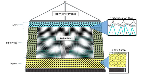
Dredge gear configuration required if the SNE/MA windowpane flounder accountability measure is in place. Image credit: Coonamessett Farm Foundation
If the scallop fishery exceeds its windowpane flounder sub-ACL by 20% or less, this gear restriction would be in place for the month of February only. If the sub-ACL is exceeded by more than 20%, the gear restriction would be in place for March and February.
Under the industry-funded observer program, if a vessel is selected to carry an observer, the vessel is responsible to pay for that observer on that trip. In order to help defray the cost to vessel owners for this observer coverage, one percent of the ABC/ACL is set aside as the Observer Set-Aside. This set-aside is then distributed to vessels that carry observers. LA vessels either receive additional pounds in access areas or DAS in open areas, and LAGC IFQ vessels receive additional pounds attributed to their IFQ allocations.
The industry-funded observer program was first used when scallop vessels gained access into portions of groundfish closed areas under Joint Framework Adjustments 11 and 39 to the Scallop and Northeast Multispecies Fishery Management Plans (FMPs), respectively. The set-aside program was expanded in Amendment 10 to the Scallop FMP to include other access areas and open areas. Since its beginning, the industry-funded observer program has applied to LA vessels, and more recently LAGC IFQ vessels were incorporated into the program. The industry-funded observer program has enabled higher observer rates in the scallop fishery compared to other fisheries in the region.
Observer Set-Aside Compensation Rate:
The observer compensation rates refer to the amount of additional pounds of scallops, or scallop DAS for LA vessels on open area trips, that will be allotted to vessels that are selected to carry observers.
Using the one-percent observer set-aside described above, as well as information on expected trip lengths, trip costs, landings-per-unit effort, and expected scallop prices, NMFS selects compensation rates that are expected to provide sufficient compensation for the observer fee, while also providing sufficient observer coverage based on anticipated coverage levels needed for a given fishing year.
Compensation Rate for LA Vessels
- 0.11 DAS per DAS fished for open area DAS trips (i.e., vessels will be charged 0.89 DAS per DAS fished with an observer onboard)
- 175 lb per day, or part of a day, for access area trips
Compensation Rate for LAGC IFQ Vessels
- 175 lb per trip for access area trips
- This equates to a possession limit of 775 lb when carrying an observer on an access area trip
NOAA Fisheries monitors the compensation rates and the observer set-aside use in each area very closely throughout the year. If information suggests that a different rate is necessary to account for unexpected fishery conditions, we will change the compensation rate as appropriate and necessary. For more details on how we calculated these compensation rates, and our expectation of how it will impact compensation and observer coverage rates, please read the FY 2016 bulletin and the Observer Compensation Rate Summary on these topics.
Permit Categories
| Permit Category | Description | Permits issued in 2014 |
| LA 2 | Full-Time | 247 |
| LA 3 | Part-Time | 2 |
| LA 4 | Occasional | 0 |
| LA 5 | Full-Time Small Dredge | 51 |
| LA 6 | Part-Time Small Dredge | 31 |
| LA 7 | Full-Time - Authorized to use trawl net | 11 |
| LA 8 | Part-Time - Authorized to use trawl net | 0 |
| LA 9 | Occasional - Authorized to use trawl net | 0 |
| LAGC A | Individual Fishing Quota | 239 |
| LAGC B | Northern Gulf of Maine | 92 |
| LAGC C | Incidental Catch | 242 |
Limited access full-time, part-time, and occasional vessel permit categories have been in place since 1994. Allocations for part-time and occasional scallop vessels are set at 40 percent and 8.33 percent of the full-time allocations, respectively.
The Council established the limited access general category permits (Individual Fishing Quota, Northern Gulf of Maine, and incidental) in 2008.
Other permit information: All Federal scallop permits require an active Vessel Monitoring System (VMS) unit.
Commercial operator permit: Operator cards are required for any operator of a charter/party boat or a commercial vessel (including carrier and processor vessels) issued a vessel permit from the Northeast Region and fishing for or in possession of fish.
Commercial dealer/processor permit: Atlantic Sea scallops may be sold only to persons possessing a valid Federal scallop dealer permit. Scallops must be purchased only from vessel owners possessing a valid scallop vessel permit.
How to obtain a Federal scallop fishing permit: All Federal scallop permits are issued under limited access programs. Therefore, a Federal scallop can only be obtained by purchasing a vessel that has already been issued one.
To renew a current Federal scallop permit please contact the permits office at (978) 281-9370. For more information, please visit the Permits website at https://www.greateratlantic.fisheries.noaa.gov/aps/permits/
Possession Limits and Fish Size Requirements
Minimum shell height: The minimum shell height for in-shell scallops that may be landed or possessed at or after landing is 3.5 inches (8.9 cm). Shell height is a straight line measurement from the hinge to the part of the shell that is farthest away from the hinge.
Maximum shell height: There is no maximum scallop size.
Possession & Trip Limits: Scallop possession limits vary by permit and area. The specifics of the catch limits for different permit holders are outlined below.
Limited Access Possession Limits
Open Area Days-at-Sea (DAS)
LA vessels fishing under a DAS in open areas are not subject to a possession limit. Sorting machines are prohibited on vessels fishing under a DAS and the following crew limits also apply:
- LA vessels may have no more than 7 people on board, including the operator
- For vessels in the Small Dredge Program (Categories 5 and 6), no more than 5 people can be on board
- These numbers exclude any observers that may be present
Access Areas
Limited Access vessels fishing in an access area have a possession limit dependent on their permit category. Below are the possession limits from FY 2016:
- Full-time: 17,000 lb/trip
- Part-time: 10,200 lb/trip
When fishing on a declared access area trip, vessels may have no more than 50 bushels of in-shell scallops when outside of the access area.
Access Area trips are now subjected to the following crew limits:
- LA vessels may have no more than 8 people on board, including the operator
- For vessels in the Small Dredge Program (Categories 5 and 6), no more than 6 people can be onboard
- These numbers exclude any observers that may be present
If a limited access vessel carries an observer on board, that vessel may land additional scallops while on an access area trip to compensate for the cost of carrying an observer.
LAGC Possession Limits
| LAGC Permit Category | Scallop Meat Possession Limit | In-Shell Possession Limit Shoreward of VMS Line | In-shell Possession Limit Seaward of VMS Line |
| IFQ – Not declared into the Access Area Program | 600 lb | 75 U.S. bu | 100 U.S. bu |
| IFQ – Declared into the Access Area Program | 600 lb† | 75 U.S. bu | 75 U.S. bu (100 bu only while inside access area) |
| NGOM | 200 lb | 25 U.S. bu | 50 U.S. bu |
| Incidental | 40 lb | 5 U.S. bu | 10 U.S. bu |
† An IFQ-permitted vessel on a declared access area trip may possess up to 750 lb of shucked scallops if it is carrying an observer and the observer set-aside for that particular access area has not been exhausted.
Shell Stock Restrictions
- Vessels fishing in areas that are closed due to paralytic shellfish poisoning (PSP).
- LA vessels fishing in or transiting the area south of 42°20′N. lat. at any time during a trip may possess no more than 50 bu (75 BU for IFQ vessels) of in-shell scallops shoreward of the Vessel Monitoring System (VMS) demarcation line, unless fishing under the state waters exemption.
- LA vessels declared into the Sea Scallop Area Access Program may not possess more than 50 bu (75 BU for IFQ vessels) of in-shell scallops outside of the access area
Other Allowed Species Possession Limits
Northeast (NE) multispecies possession limits for LAGC IFQ vessels: LAGC IFQ vessels are prohibited from landing NE multispecies, unless they are on a declared NE multispecies trip (i.e., they cannot be on a declared IFQ trip and retain NE multispecies).
NE multispecies possession limits on Access Area Trips: Unless otherwise prohibited, limited access scallop vessels, also issued a valid NE multispecies permit, that have declared into a trip and fishing within the Sea Scallop Access Areas may possess and land, per trip, up to a maximum of 1,000 lb of all New England multispecies combined. Additional restrictions for Atlantic cod, haddock, and yellowtail flounder are listed below:
- Atlantic cod - Vessels may possess up to 100 lb (45.4 kg) of Atlantic cod per trip, provided such fish is intended for personal use only and cannot be not sold, traded, or bartered
- Haddock - Vessels may possess and land haddock up to the overall possession limit of all NE multispecies combined, except that vessels are prohibited from possessing or landing haddock from January 1 through June 30
- Yellowtail flounder - vessels are prohibited from possessing yellowtail flounder
NE multispecies possession limits on Scallop DAS trips: Unless otherwise prohibited, limited access scallop vessels, also issued a valid NE multispecies permit, that have declared into the scallop DAS program may possess and land, per trip:
- NE multispecies - A maximum of 300 lb of all NE multispecies combined
- Yellowtail flounder - vessels are prohibited from possessing yellowtail flounder
|
Monkfish Incidental Trip Limits for LA vessels while on a Scallop DAS or in the Sea Scallop Access Area Program |
|
| Area |
NFMA & SFMA |
| Gear |
All gear |
| Landing Limit (tail weight per DAS) |
300 lb |
Monkfish Incidental Trip Limits for LAGC IFQ vessels:
- 50 lb (tail weight) per trip, when fishing in the scallop dredge exemption areas
- When fishing west of 72’30’’ (i.e., in the Mid-Atlantic exemption area), LAGC vessels may use trawls or dredges, and the monkfish possession limit depends on gear size::
- Mesh size equal to or larger than 5.5” diamond/6” square in body, extensions, and codend – 5% of the total weight of fish on board, up to 450 lb trip
Mesh size smaller than 5.5” diamond/6” square in body, extensions, and codend – 50 lb per day, up to 150 lb per trip
Maximum Fish Size: None
Dredge Gear Requirements:
 |
 |
Maximum Dredge Width: Limited Access vessels (excluding vessels in the Small Dredge Program) may not use a dredge(s) with a combined dredge width of more than 31 ft. Limited Access vessels enrolled in the Small Dredge Program may only fish with one dredge, and the dredge width may not exceed 10.5 ft.
LAGC vessels may fish with a maximum combined dredge width of 10.5 ft, measured at the widest point in the bail of the dredge. The only exception is for LAGC vessels fishing in the Mid-Atlantic Exemption Area, where vessels may use dredge gear with a combined dredge width of no more than 31 ft.
Minimum mesh size: The mesh size of any material on the top of any scallop dredge (twine top) may not be smaller than 10-inch square or diamond mesh.
Minimum Ring Size: The ring size in any scallop dredge possessed or used by scallop vessels may not be smaller than 4 inches.
Link restrictions: No more than double links between rings may be used in or on all parts of the dredge bag, except the dredge bottom. No more than triple linking shall be used in or on the dredge bottom portion and the diamonds.
Damaged links that are connected to only one ring, i.e., “hangers,” are allowed if they occur between two links that both couple the same two rings. Dredge rings may not be attached via links to more than four adjacent rings. Thus, dredge rings must be rigged in a configuration such that, when a series of adjacent rings are held horizontally, the neighboring rings form a pattern of horizontal rows and vertical columns.
Gear Restrictions and Obstructions: No material, device, or link configuration may be used if it results in obstructing the release of scallops that would have passed through a legal sized and configured net and dredge. No chafing gear or cookies may be used on the top of the dredge.
All limited access and LAGC IFQ vessels that are fishing for scallops must have no more than seven rows in the apron between the twine top and the clubstick, year-round and in all areas. This is intended to further reduce flatfish bycatch.

Scallop Dredge Gear Stowage Requirements:
Scallop vessels may transit closed areas and access areas (excluding Closed Area II and Elephant Trunk Closed Area, unless there is a compelling safety reason to do so) on either a scallop access area or open area trip, provided gear is properly stowed.
Seasonal Turtle Chain Mat and Turtle Deflector Dredge (TDD) Requirements:
Effective Date, Season, and Area Required:
- Between May 1 and November 30
- Scallop vessels fishing west of 71° W. longitude must use both TDDs and Turtle chain mats during the entire TDD and chain mat season
Chain Mat Description: The mat must cover the entire opening of the dredge bag. The vertical and horizontal chains must be hung to cover the opening of the dredge bag such that the vertical chains extend from the back of the cutting bar to the sweep. The horizontal chains must intersect the vertical chains such that the length of each side of the openings formed by the intersecting chains is less than or equal to 14 inches with the exception of the side of any individual opening created by the sweep. The sweep is defined as a chain extending, usually in an arc, from one end of the dredge frame to the other which the ring bag including the diamonds, is attached. The sweep forms the edge of the opening of the dredge bag.
Which Vessels Have to Use the TDD?
All scallop vessels fishing in the TDD area during the TDD season described above with the exception of Limited Access General Category (LAGC) vessels that use a dredge less than 10’ 6” in width. Specific examples are listed below.
What are the Requirements of the TDD Design?
(1) The cutting bar must be located in front of the depressor plate.
(2) The acute angle between the plane of the bale and the strut must be less than or equal to 45 degrees.
(3) All bale bars must be removed, except the outer bale (single or double) bars and the center support beam, leaving an otherwise unobstructed space between the cutting bar and forward bale wheels, if present. The center support beam must be less than 6” wide. For the purpose of flaring and safe handling of the dredge, a minor appendage, not to exceed 12” in length, may be attached to each of the outer bale bar (“flaring bar”). If the flaring bar is attached in a u-shape, none of the three sides of the flaring bar can exceed 12 inches in length. The appendage should at no point be closer than 12” to the cutting bar so that it does not interfere with the space created by the “bump out”.
(4) Struts must be spaced no more than 12” apart from each other, along the entire length of the frame.
(5) For all dredges with widths of 10’ 6” or greater, the TDD must include a straight extension ("bump out") connecting the outer bale bars to the dredge frame. This "bump out" must exceed 12” in length, as measured along the inside of the bale bar from the front of the cutting bar to the first bend in the bale bar.
Trawl Gear Requirements
Authorized Scallop Trawl Vessels:
Limited Access vessels permitted to use trawl gear (Categories 7, 8, and 9) to harvest scallops must comply with the maximum sweep, minimum mesh, and gear obstruction requirements of the Northeast Multispecies regulations. Trawl gear is not allowed in the northern scallop access areas (Closed Area I, Closed Area II, and Nantucket Lightship).
Limited Access General Category scallop vessels fishing west of 72°30’ W. longitude in the Mid-Atlantic Exemption Area, may fish for scallops with trawl gear provided they comply with all applicable trawl gear restrictions, which depend on the species retained, including scallops.
Maximum sweep: The trawl sweep of nets shall not exceed 144 ft, as measured by the total length of the footrope that is directly attached to the webbing, unless the net is properly stowed and not available for immediate use.
Minimum mesh size: The mesh size for any scallop trawl net in all areas shall not be smaller than 5.5 inches. However, if a vessel possesses other species, other mesh size restrictions may apply.
Scallop Trawl Gear Stowage: Scallop vessels may transit closed areas and access areas (excluding Closed Area II and Elephant Trunk Closed Area, unless there is a compelling safety reason to do so) on either a scallop access area or open area trip, provided gear is properly stowed.
Chart of Scallop Management Areas

(Click to see a full size image of the above chart)
2016 Atlantic Sea Scallop Access Area Coordinates
|
Hudson Canyon Scallop Access Area |
||
|
Point |
N. Latitude |
W. Longitude |
|
H1 |
39°30′ |
73°10′ |
|
H2 |
39°30′ |
72°30′ |
|
H3 |
38°30′ |
73°30′ |
|
H4 |
38°50′ |
73°30′ |
|
H5 |
38°50′ |
73°42′ |
|
H1 |
39°30′ |
73°10′ |
|
Elephant Trunk Scallop Access Area |
||
|
Point |
N. Latitude |
W. Longitude |
|
ETAA1 |
38°30’ |
74°20’ |
|
ETAA2 |
38°30’ |
73°50’ |
|
ETAA3 |
38°40’ |
73°50’ |
|
ETAA4 |
38°40′ |
73°40′ |
|
ETAA5 |
38°50′ |
73°40′ |
|
ETAA6 |
38°50′ |
73°30′ |
|
ETAA7 |
38°10′ |
73°30′ |
|
ETAA8 |
38°10′ |
74°20′ |
|
ETAA1 |
38°30′ |
74°20′ |
|
Delmarva Scallop Access Area |
||
|
Point |
N. Latitude |
W. Longitude |
|
DMV1 |
38°10′ |
74°50′ |
|
DMV2 |
38°10′ |
74°00′ |
|
DMV3 |
37°15′ |
74°00′ |
|
DMV4 |
37°15′ |
74°50′ |
|
DMV1 |
38°10′ |
74°50′ |
The Nantucket North Access Area is open for LAGC IFQ vessels only
|
Nantucket Lightship North Sea Scallop Access Area - **IFQ only** |
||
|
Point |
N. Latitude |
W. Longitude |
|
NLNAA1 |
40°50′ |
69°00′ |
|
NLNAA2 |
40°30′ |
69°00′ |
|
NLNAA3 |
40°30′ |
69°30′ |
|
NLNAA4 |
40°50′ |
69°30′ |
|
NLNAA1 |
40°50′ |
69°00′ |
2016 Atlantic Sea Scallop Closed Areas
|
Closed Area 1 |
|||
|
Point |
N. Latitude |
W. Longitude |
Note |
|
CAIA1 |
41°26′ |
68°30′ |
|
|
CAIA2 |
40°58′ |
68°30′ |
|
|
CAIA3 |
40°54.95′ |
68°53.37′ |
(1) |
|
CAIA4 |
41°04′ |
69°01′ |
(1) |
|
CAIA1 |
41°26′ |
68°30′ |
|
1From Point CAIA3 to Point CAIA4 along the western boundary of Closed Area I, defined in § 648.81(a)(1).
|
Closed Area 2 |
|||
|
Point |
N. Latitude |
W. Longitude |
Note |
|
CAIIA1 |
41°00′ |
67°20′ |
|
|
CAIIA2 |
41°00′ |
66°35.8′ |
|
|
CAIIA3 |
41°18.45' |
(1) |
(2) |
|
CAIIA4 |
41°30′ |
(3) |
(2) |
|
CAIIA5 |
41°30′ |
67°20′ |
|
|
CAIIA1 |
41°00′ |
67°20′ |
|
1The intersection of 41°18.45' N. lat. and the U.S.-Canada Maritime Boundary, approximately 41°18.45' N. lat. and 66°24.89' W. long.
2From Point CAIIA3 connected to Point CAIIA4 along the U.S.-Canada Maritime Boundary.
3The intersection of 41°30′ N. lat. and the U.S.-Canada Maritime Boundary, approximately 41°30′ N. lat., 66°34.73′ W. long.
|
Closed Area 2 Extension |
|||
|
Point |
N. Latitude |
W. Longitude |
Note |
|
CAIIE1 |
40°30' |
67°20′ |
|
|
CAIIE2 |
41°00′ |
67°20′ |
|
|
CAIIE3 |
41°00′ |
66°35.8′ |
|
|
CAIIE4 |
41°18.45′ |
(1) |
(2) |
|
CAIIE5 |
40°30′ |
(3) |
(2) |
|
CAIIE1 |
40°30' |
67°20′ |
|
1The intersection of 41°18.45′ N. lat. and the U.S.-Canada Maritime Boundary, approximately 41°18.45′ N. lat. and 66°24.89′ W. long.
2From Point CAIIE4 to Point CAIIE5 following the U.S.-Canada Maritime Boundary.
3The intersection of 40°30′ N. lat. and the U.S.-Canada Maritime Boundary, approximately, 65°44.34'W. long.
|
Nantucket Lightship Closed Area* |
||
|
Point |
N. Latitude |
W. Longitude |
|
NLAA1 |
40°50′ |
69°30′ |
|
NLAA2 |
40°50′ |
69°00′ |
|
NLAA3 |
40°33’ |
69°00’ |
|
NLAA4 |
40°33’ |
68°48’ |
|
NLAA5 |
40°20’ |
68°48’ |
|
NLAA6 |
40°20′ |
69°30′ |
|
NLAA1 |
40°50′ |
69°30′ |
|
Elephant Trunk Closed Area |
||
|
Point |
N. Latitude |
W. Longitude |
|
ETCA 1 |
38°50’ |
74°20’ |
|
ETCA 2 |
38°50’ |
73°40’ |
|
ETCA 3 |
38°40’ |
73°40’ |
|
ETCA 4 |
38°40’ |
73°50’ |
|
ETCA 5 |
38°30’ |
73°50’ |
|
ETCA 6 |
38°30’ |
74°20’ |
|
ETCA 1 |
38°50’ |
74°20’ |
Other Atlantic Sea Scallop Management Area Coordinates
|
NGOM Scallop Management Area |
||
|
Point |
N. Latitude |
W. Longitude |
|
NGOM1 |
42°20' |
Massachusetts Shoreline |
|
NGOM2 |
42°20' |
69°40' |
|
NGOM3 |
42°49.5' |
69°40' |
|
NGOM4 |
43°12' |
69°00' |
|
NGOM5 |
43°41' |
68°00' |
|
G2 |
43°58' |
67°22' |
|
G1 |
(1) |
(1) |
(1)Northward along the irregular U.S.-Canada maritime boundary to the shoreline
|
GOM Scallop Dredge Exemption Area |
||
|
Point |
N. Latitude |
W. Longitude |
|
SM1 |
41°35′ |
70°00′ |
|
SM2 |
41°35′ |
69°40′ |
|
SM3 |
42°49.5′ |
69°40′ |
|
SM4 |
43°12′ |
69°00′ |
|
SM5 |
43°41′ |
68°00′ |
|
SM6 |
43°58′ |
67°22′ |
|
SM7 |
(1) |
(1) |
(1) Northward along the irregular U.S.-Canada maritime boundary to the shoreline
|
Great South Channel Scallop Dredge Exemption Area |
||
|
Point |
N. Latitude |
W. Longitude |
|
GSC 1 |
42°06′ |
69°40′ |
|
GSC 2 |
41°30′ |
69°10′ |
|
GSC 3 |
41°30′ |
69°23′ |
|
GSC 4 |
40°50′ |
68°49.2′ |
|
GSC 5 |
40°50′ |
69°29.46′ |
|
GSC 6 |
41°10′ |
69°50′ |
|
GSC 7 |
41°10′ |
70°00′ |
|
GSC 8 |
41°35′ |
70°00′ |
|
GSC 9 |
41°35′ |
69°40′ |
Southern New England Scallop Dredge Exemption Area
(A) Bounded on the west, south and east by straight lines connecting the following points in the order stated:
|
Point |
N. Latitude |
W. Longitude |
|
Sc1 |
(1) |
72°30′ |
|
Sc2 |
40°00′ |
72°30′ |
|
Sc3 |
40°00′ |
71°40′ |
|
Sc4 |
39°50′ |
71°40′ |
|
Sc5 |
39°50′ |
70°00′ |
|
Sc6 |
(2) |
70°00′ |
|
Sc7 |
(3) |
70°00′ |
|
Sc8 |
(4) |
70°00′ |
(1)South facing shoreline of Long Island, NY
(2)South facing shoreline of Nantucket, MA
(3)North facing shoreline of Nantucket, MA
(4)South facing shoreline of Cape Cod, MA
(B) Bounded on the northwest by straight lines connecting the following points in the order stated:
|
Point |
N. Latitude |
W. Longitude |
|
Sc9 |
41°00′ |
(1) |
|
Sc10 |
41°00′ |
71°40′ |
|
Sc11 |
(2) |
71°40′ |
(1)East facing shoreline of the south fork of Long Island, NY
(2)South facing shoreline of RI
The Mid-Atlantic Exemption Area
This area is bounded on the east by the western boundary of the Southern New England Dredge Exemption area, as described above.
Protected Resources and Marine Mammal Regulations
It is illegal to harvest or possess protected species unless otherwise specified under the regulations implementing the Endangered Species Act or Marine Mammal Protection Act. Please see links below for more information or contact NMFS, Greater Atlantic Regional Office Protected Resources Division at (978) 281-9328.
- Handling and Resuscitation Requirements
- Please see the Gear tab for more information regarding Turtle Deflector Dredge (TDD) and chain mat requirements for the scallop fishery.
- Atlantic Sturgeon - Endangered and threatened
- Shortnose Sturgeon – Endangered
- Atlantic Salmon - The Gulf of Maine (GOM) distinct population segment (DPS) of Atlantic salmon is endangered.
Charter/Party or Recreational Rules and Regulations
- There is no Charter/Party component to the scallop fishery in Federal waters.
- Atlantic sea scallops may only be harvested from Federal waters by vessels issued a Federal scallop permit. Therefore Atlantic sea scallops may not be harvested from Federal waters by recreational anglers
Reporting
Vessel Monitoring System (VMS) Requirements: All vessels issued a Federal scallop permit are required to have an active VMS unit and must use their VMS unit to declare all vessel activity including fishing trips and transiting.
Interactive Voice Response (IVR) Requirements: The IVR system is only used in the scallop fishery to report RSA trip start, end, and catch.
Observer Requirements:
- Limited Access (LA) Vessels: Call for both Open Area and Access Area trips. 72 hours notice before the intended sail date is required and notice should be no more than 10 days prior to sail date.
- LA General Category Vessels: Call for both Open Area and Access Area trips. Notify weekly by Thursday if you expect to make any trips from Sunday through Saturday of the following week.
The Industry-Funded Scallop Observer Program Call-In Guide can be found by clicking here.
Catch Reporting and Vessel Trip Reports:
Vessel Trip Reports: A vessel trip report (VTR) must be received by NMFS or postmarked within 15 days after the end of the reporting month. For vessels that also hold a NE multispecies permit, VTRs must be submitted weekly by Tuesday of the week after the fishing trip ends. Copies of VTRs must be retained on board the vessel for 1 year after the date of the last entry on the log and otherwise retained for 3 years after the date of the last entry on the log. If no fishing activity took place during a reporting period (week or month), then a VTR must be submitted stating that no fishing trips were taken. Instructions for completing the VTRs can be found by clicking here.
VMS Catch Reports: There are two catch reports which scallop vessels may be required to submit through VMS. Instructions for completing the VMS forms can be found by clicking here.
Scallop Catch Report
The first form is required by all LA and LAGC IFQ vessels that are fishing for, possessing, or retaining scallops, and not also fishing under a NE multispecies DAS or sector allocation. The form, often referred to as the scallop catch report, is used to monitor scallop and yellowtail flounder catch on scallop trips.
These reports must be submitted in 24-hour intervals for each day of fishing that begins at 0000 hours and ends at 2400 hours. The reports must be submitted before 9:00 a.m. local time each day for the previous day’s catch. The reports include:
- Fishing Vessel Trip Report logbook page number;
- Total pounds of scallop meats kept;
- Total pounds of all other fish kept.
The Scallop Pre-Landing Notification Form
The second report relevant to scallop fishing activities is the Scallop Pre-Landing Notification Form, which is required under the following four circumstances:
- When on a declared limited access general category (LAGC) trip;
- When a vessel with an LAGC IFQ or Northern Gulf of Maine scallop permit is on a declared trip outside the scallop fishery when scallops are kept;
- When on a declared limited access scallop access area trip; or
- When declaring out of a limited access scallop open area trip to transit to a port south of 39° N with scallops onboard (send this report immediately once shoreward of the VMS demarcation line at or south of 39° N).
(This includes limited access vessels that are also issued IFQ or NGOM permits when these vessels are landing scallops when not on a declared scallop day-at-sea or on an access area trip allocated through their full-time, part-time, or occasional permits.)
The pre-landing notification form must be submitted at least 6 hours before landing scallops, and before crossing the VMS demarcation line. If your scallop harvesting ends less than 6 hours before landing, then the report is to be sent immediately upon leaving the fishing grounds.
This form serves two important purposes: (1) To support timely monitoring and attribution of scallop landings to vessel permits; and (2) to notify NOAA’s Office of Law Enforcement (OLE) of where vessel operators plan to land scallops.