National Weather Service United States Department of Commerce

Locally heavy rainfall possible in the southern High Plains

A slow moving low pressure system will bring showers and thunderstorms to much of central Texas Sunday into Monday. Some of the storms will contain heavy rainfall which could produce localized flooding. Read More >

Click a location below for detailed forecast.

Last Map Update: Sun, Nov. 6, 2016 at 7:11:30 pm EST

National Weather Service Louisville, KYNational Weather Service Jackson, KYNational Weather Service Charleston, WV
National Weather Service Nashville, TNZoom
Out

National Weather Service Blacksburg, VA
National Weather Service Huntsville, ALNational Weather Service Peachtree City, GANational Weather Service Greer, SC

Drought conditions continue to expand.
Each observation point is apart of our COOP program (Cooperative Observer Program). Each site has a 24 hour observation period that ends and begins at 8 am local time. Each site records temperature, precipitation, and snowfall data. More information about the COOP program can be found here www.nws.noaa.gov/om/coop/ Data began being collected at: Cades Cover on 01/01/1999 || Mount LeConte on 07/01/1987 || Newfound Gap on 01/01/1991 || Sugarlands Visitor Center on 12/01/1921
More information on this climate data can be found at http://www.weather.gov/mrx/dailyclimateimageinfo

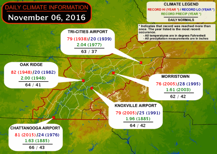
Local Weather History For November 6th...
In 1977, 6 counties in northeast TN declared disaster areas. Over 3" of rain fell. 1 drowned.