|
Digital Elevation Model (DEM) Discovery Portal

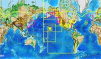
NCEI created a geospatial online catalog that links to web-published digital elevation models (DEMs). This "DEM Discovery Portal" uses an ArcGIS map interface to locate, preview, and link to DEM web pages for download. DEMs may be bathymetric, topographic, or a merged combination of both. They also range from high-resolution coastal DEMs for local studies to coarser DEMs with global coverage. DEM usage ranges from ecologists mapping fish habitat to hurricane modelers estimating coastal storm-surge inundation.
The portal displays a world map showing the footprints of DEMs referenced in the portal, with links to the appropriate web pages for DEM download. DEM information in the portal includes source, cell size, horizontal and vertical datums, type of coverage (bathymetric, topographic, or integrated), file format, and links to web sites for DEM download.
DEMs can be readily added to the portal's catalog if they are published on the web. To add a web-published DEM to the "DEM Discovery Portal", contact NCEI with web links and DEM metadata.
|
|