


National Forecast Charts Legacy Page:
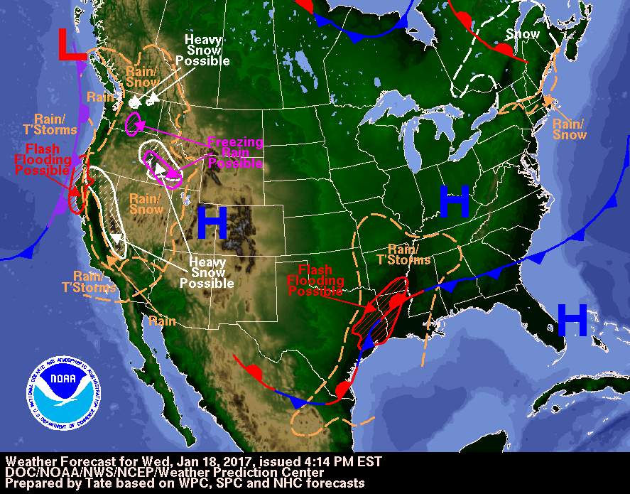
Valid Fri Jan 20, 2017
Valid Sat Jan 21, 2017
Valid Sun Jan 22, 2017

Image Format:
+ Additional Links
- » Description of the National Forecast Chart
- » Product Archives
- » Download hazards in KML or shapefile format


North American Surface Analysis Legacy Page:
Analyzed at 00Z Fri Jan 20, 2017
Analyzed at 03Z Fri Jan 20, 2017
Analyzed at 06Z Fri Jan 20, 2017
Analyzed at 09Z Fri Jan 20, 2017
Analyzed at 12Z Fri Jan 20, 2017
Analyzed at 15Z Fri Jan 20, 2017
Analyzed at 18Z Fri Jan 20, 2017
Analyzed at 21Z Fri Jan 20, 2017
Analyzed at 00Z Sat Jan 21, 2017
Image Format:


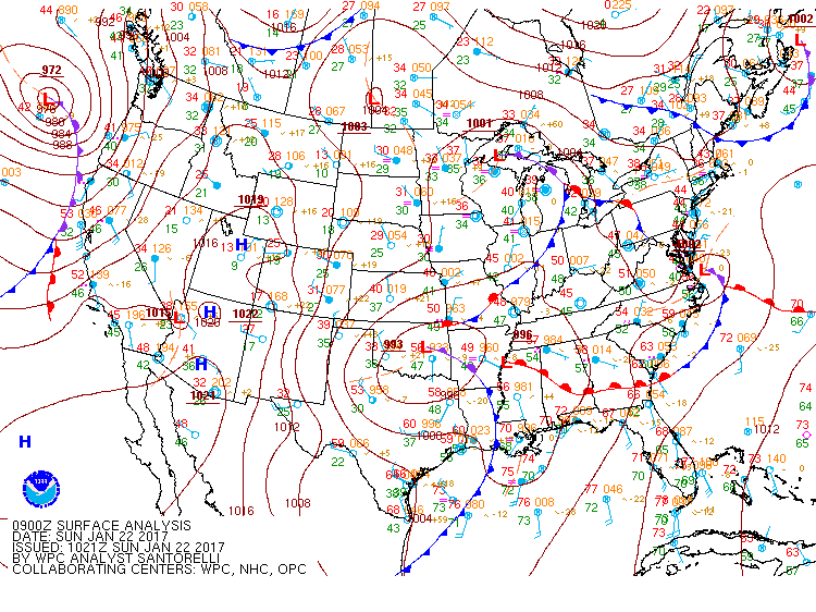


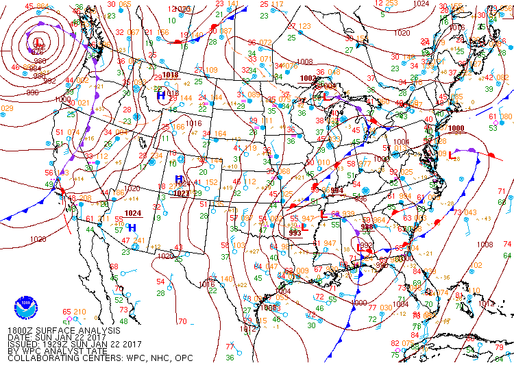


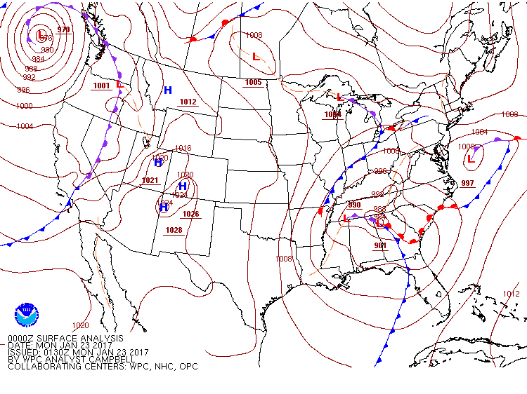
Surface Fronts and Sea-Level Pressures Legacy Page:
Analyzed 00Z Sat Jan 21, 2017
Valid 06Z Sat Jan 21, 2017
Valid 12Z Sat Jan 21, 2017
Valid 18Z Sat Jan 21, 2017
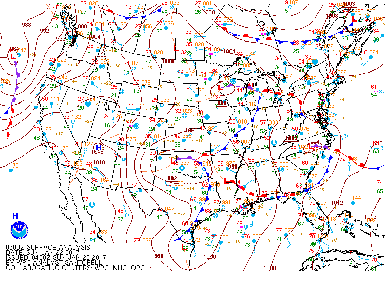
Valid 00Z Sun Jan 22, 2017
Valid 12Z Sun Jan 22, 2017
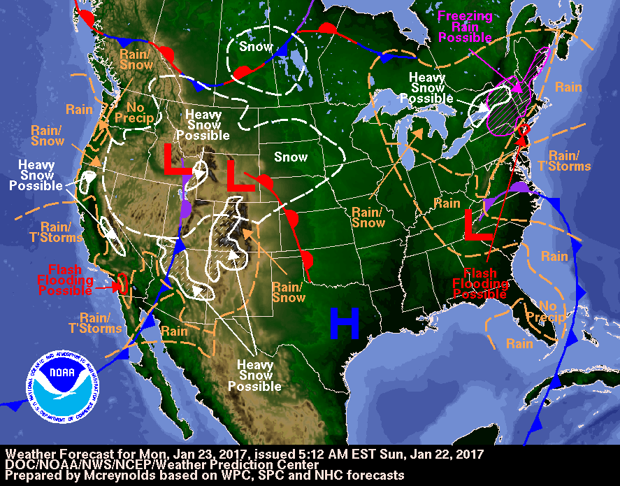
Valid 00Z Mon Jan 23, 2017
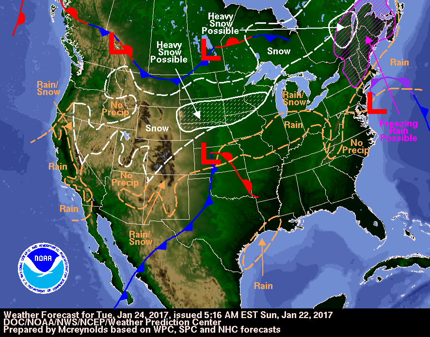
Valid 12Z Tue Jan 24, 2017
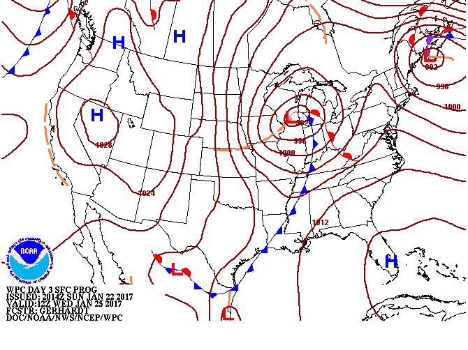
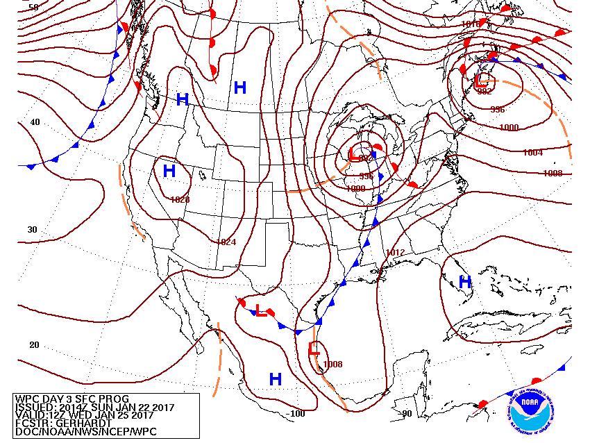
Valid 12Z Wed Jan 25, 2017
Valid 12Z Thu Jan 26, 2017
Valid 12Z Fri Jan 27, 2017
Valid 12Z Sat Jan 28, 2017


+ Short Range Forecast Discussion (Day ½-2½)
+ Medium Range Forecast Discussion (Day 3-7)
+ Additional Links
Short Range Forecast Discussion
NWS Weather Prediction Center College Park MD
255 PM EST Fri Jan 20 2017

Valid 00Z Sat Jan 21 2017 - 00Z Mon Jan 23 2017

...Severe thunderstorms possible through the weekend across
portions of the Gulf Coast and Southeast...

...Heavy snow possible from the higher elevations of California to
the central and southern Rockies...

Periods of scattered to numerous showers and thunderstorms are
expected through much of the weekend from portions of the Gulf
Coast and lower Mississippi valley to the Southeast, as a series
of upper-level disturbances move overhead. One round of showers
and thunderstorms is expected by this evening along much of the
Gulf Coast, spreading across portions of the Southeast overnight
into Saturday morning. On Saturday, a warm front will develop
across the region, which will once again focus numerous showers
and thunderstorms through the day and into the overnight hours. A
low pressure system forecast to take shape across the southern
plains on Saturday will move east into the lower Mississippi
valley by Sunday morning. This system will bring yet another day
of widespread showers and thunderstorms from the lower Mississippi
valley and Gulf Coast to the Southeast. Severe thunderstorms are
possible through the weekend in association with each of these
rounds of showers and storms. Please refer to products issued by
the Storm Prediction Center for further details on the severe
weather threat. Rain will also spread north into the Mid-Atlantic
region by Sunday.

The weather pattern will also be an active one across the western
U.S. through the weekend, as a series of Pacific storms move
onshore. The first of these storm systems is moving into the West
Coast states today, and will bring rain and thunderstorms to areas
along the coast as well as in the Desert Southwest tonight and
Saturday. Heavy snow is possible across portions of the Sierras as
well as the Mogollon Rim and the central/southern Rockies tonight
into Saturday. The West Coast should see a very brief lull in
precipitation during the day on Saturday before another more
powerful Pacific storm system begins to approach late in the day.
This second system will spread rain and mountain snow along nearly
the entire West Coast Saturday night into Sunday. Snow will also
spread across much of the interior West on Sunday. Heavy snow will
be possible in association with this system once again across the
mountains of California, as well as across portions of the Great
Basin through Sunday. Heavy rain is also expected at lower
elevations of California.

Lastly, the northern plains and Upper Midwest will also see the
potential for some relatively light precipitation tonight through
the weekend as a slow-moving upper-level disturbance remains in
the vicinity. A mix of rain, snow, sleet, and freezing rain is
possible tonight through Saturday from the northern plains to the
Upper Great Lakes. Scattered lighter precipitation will linger
across the Upper Midwest into Sunday, with a wintry mix still
possible.


Ryan


Graphics available at www.wpc.ncep.noaa.gov/basicwx/basicwx_wbg.php
EXTENDED FORECAST DISCUSSION
NWS WEATHER PREDICTION CENTER COLLEGE PARK MD
836 AM EST FRI JAN 20 2017

VALID 12Z MON JAN 23 2017 - 12Z FRI JAN 27 2017

...SNOW POTENTIAL FOR THE INTERIOR NORTHEAST AND CENTRAL/HIGH
PLAINS TO THE UPPER MIDWEST NEXT WEEK...


SYNOPTIC PATTERN & MODEL PREFERENCES
~~~~~~~~~~~~~~~~~~~~~~~~~~~~~~~~~~~~
RETROGRADING RIDGING ACROSS CANADA FORCED BY A TROUGH SHARPENING
ALONG 160W LONGITUDE SHOULD REORIENT THE TROUGH, STRETCHING FROM
EASTERN CANADA THROUGH THE CENTRAL/SOUTHERN PLAINS TOWARDS THE SEA
OF CORTEZ/GULF OF CALIFORNIA.  THE GUIDANCE REMAINS IN BETTER THAN
AVERAGE AGREEMENT.  FOR THE PRESSURES, 500 HPA HEIGHTS, AND WIND
GRIDS, A COMPROMISE OF THE 00Z CANADIAN/00Z ECMWF/00Z UKMET/06Z
GFS WAS UTILIZED EARLY BEFORE USING INCREASING AMOUNTS OF THE 00Z
ECMWF ENSEMBLE MEAN AND 00Z NAEFS MEAN MID TO LATE NEXT WEEK.
OTHER WEATHER GRIDS WILL BE MORE HEAVILY ENSEMBLE MEAN BASED TO
REFLECT FORECAST UNCERTAINTY.  THE DAYS 4-7 QPF WILL START OUT AS
A COMPROMISE OF THE 06Z GFS/00Z ECMWF, WITH SOME 12Z GFS THROWN IN
MIDDAY IF ITS MASS FIELDS LOOK REASONABLE.


WEATHER HIGHLIGHTS/THREATS
~~~~~~~~~~~~~~~~~~~~~~~~~~
THE LEAD SYSTEM IN THE EAST/NORTHEAST WILL LIKELY TRANSPORT
SIGNIFICANT MOISTURE FROM THE TROPICS/SUBTROPICS NORTH THEN
NORTHWEST INTO MILD AIR FOR THIS TIME OF THE YEAR FOR AN ARRAY OF
WINTRY PRECIPITATION TYPES. INGREDIENTS ARE THERE FOR AN INTERIOR
EVENT THANKS TO WARMER TEMPERATURES ALOFT IMPORTED BY THIS SYSTEM
AND A CANADIAN HIGH PRESSURE TO THE NORTH KEEPING COOLER AIR AT
THE SURFACE.  AN UPSTREAM KICKER WILL ENSURE THIS ONE WILL NOT
LINGER BUT PRECIPITATION RATES COULD BE IMPRESSIVE.

SIGNIFICANT PRECIPITATION SHOULD DIMINISH IN THE WEST AND INTERIOR
WEST BY MIDWEEK AS THE UPPER TROUGH SWINGS INTO THE PLAINS.
WIDESPREAD MOUNTAIN SNOWS FROM THE SIERRAS TO THE WASATCH AND THE
MOGOLLON RIM TO THE COLORADO ROCKIES SHOULD WIND DOWN TUESDAY INTO
WEDNESDAY AS THE SURFACE LOW ORGANIZES OVER KANSAS AND LIFTS
NORTHEASTWARD. SNOW WILL EXPAND TO THE NORTHEAST ON THE NORTH SIDE
OF THE LOW WHERE SIGNIFICANT ACCUMULATIONS ARE POSSIBLE. AXIS OF
HEAVIEST QPF SHOULD BE NEAR THE NE/SD BORDER INTO SOUTHERN WI.

BY LATER IN THE WEEK, PATTERN BECOMES QUIET AS THE FRONT SETTLES
INTO FLORIDA AND HIGH PRESSURE IS IN FIRM CONTROL OF THE WEST,
SEIZING INCREASING TERRITORY TO THE EAST WITH TIME. DESPITE THE
HIGHER 500 HPA HEIGHTS, NORTHERLY UPPER FLOW AND 700MB TEMPS ABOUT
1-2 SIGMAS BELOW AVERAGE WILL KEEP TEMPERATURES DOWN.  MILD
TEMPERATURES IN THE EAST SHOULD TREND BACK TOWARD CLIMATOLOGY AS
TROUGHING INCREASES ACROSS THE AREA. LAKE EFFECT SNOW PRODUCTION
WILL PICK UP THURSDAY/FRIDAY WITH NORTH/NORTH-NORTHWEST FLOW.

ROTH/FRACASSO
Quantitative Precipitation Forecasts Legacy Page:


» View
Probabilistic Precipitation Guidance (Day 1-3)
+ Forecast Discussion (Day 1-3)
+ Additional Links
+ Forecast Discussion (Day 1-3)
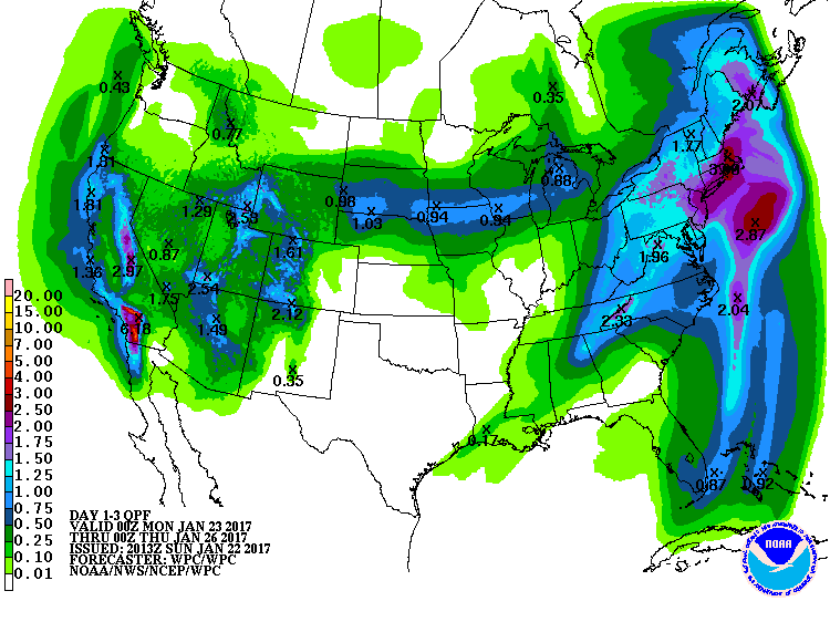
QUANTITATIVE PRECIPITATION FORECAST DISCUSSION
NWS WEATHER PREDICTION CENTER COLLEGE PARK MD
436 PM EST FRI JAN 20 2017


FINAL DAY 1...DAY 2 AND DAY 3 QPF DISCUSSION
VALID JAN 21/0000 UTC THRU JAN 24/0000 UTC
REFERENCE AWIPS GRAPHICS UNDER...PRECIP ACCUM - 24HR


DAY 1

CENTRAL GULF COAST INTO THE SOUTHEAST

LOWERING HEIGHTS IN THE ACTIVE SOUTHERN STREAM FLOW ACROSS THE
LOWER 48 WILL RE-STRENGTHEN THE LOW LEVEL SOUTH SOUTHWESTERLY FLOW
OF THE GULF OF MEXICO---RAISING PW VALUES TO 1.5 TO 2.0+ STANDARD
DEVIATIONS ABOVE THE MEAN FROM THE CENTRAL GULF COAST INTO THE
SOUTHEAST.  THE STRENGTHENING UPPER DIFFLUENCE AHEAD OF THE ABOVE
MENTIONED HEIGHT FALLS WILL SUPPORT WIDESPREAD HEAVY RAINFALL
AMOUNTS IN THIS HIGH PW AXIS.  MODELS ARE SHOWING DIFFERENCES WITH
RESPECT TO THE AXIS OF THIS HEAVY PRECIPITATION.  THE DAY 1 QPF
LEANED MORE TOWARD THE DETAILS OF THE HI RES ARW WHICH HAS SHOWN
BETTER SKILL OVERALL WITH DEPICTION OF ORGANIZED CONVECTIVE
EVENTS.  TRAINING OF CELLS IN A WEST SOUTHWEST TO EAST
NORTHEASTERLY DIRECTION POSSIBLE ALONG THE GULF COAST---WITH
RUNOFF ISSUES POSSIBLE IN AREAS OF TRAINING.  1 TO 2 INCH AREAL
AVERAGE AMOUNTS DEPICTED ALONG THE CENTRAL GULF COAST INTO THE
SOUTHEAST--WITH ISOLATED HEAVIER TOTALS IN AREAS OF TRAINING.

UPPER MS VALLEY INTO THE UPPER LAKES

THE COMBINATION OF A LEAD AREA OF HEIGHT FALLS LIFTING NORTHWARD
FROM THE UPPER MS VALLEY INTO THE UPPER LAKES EARLY DAY
1---FOLLOWED BY A SECOND AREA OF HEIGHT FALLS PUSHING NORTH FROM
THE CENTRAL PLAINS INTO THE UPPER MS VALLEY AND UPPER LAKES WILL
SUPPORT A STRIPE OF MODERATE PRECIP TOTALS DAY 1 ACROSS PORTIONS
OF THE UPPER MS VALLEY INTO THE  UPPER LAKES.  ABOVE AVERAGE TEMPS
ACROSS THIS REGION SHOULD KEEP THE WINTER WEATHER THREAT AT A
MINIMUM WITH AT BEST SOME LIGHT SNOW TOTALS OVER NORTHERN MN.  SEE
THE LATEST QPFHSD FOR ADDITIONAL WINTER WEATHER INFORMATION.

SOUTHWEST---GREAT BASIN INTO THE CENTRAL TO SOUTHERN ROCKIES

THE LATEST SURGE OF HEAVY PRECIPITATION TO AFFECT CALIFORNIA WILL
BE PUSHING INLAND INTO THE SOUTHWEST---GREAT BASIN AND CENTRAL TO
SOUTHERN ROCKIES AS THE ASSOCIATED HEIGHT FALLS MOVE EASTWARD.
WITH PW VALUES FORECAST TO BE MUCH ABOVE AVERAGE AHEAD OF THESE
HEIGHT FALLS---WIDESPREAD  MODERATE TO HEAVY PRECIP TOTALS LIKELY
ACROSS THE SOUTHWEST---GREAT BASIN AND CENTRAL TO SOUTHERN
ROCKIES.  OVERALL---THERE IS GOOD MODEL AGREEMENT WITH THE
PRECIPITATION DISTRIBUTION--WITH MAX AMOUNTS DEPICTED THROUGH THE
MOGOLLON---SOUTHWARD INTO SOUTHEAST AZ/SOUTHWEST NM AND ACROSS THE
SOUTHERN WASATCH AND SOUTHWEST COLORADO ROCKIES.

PACIFIC NORTHWEST INTO CALIFORNIA

IN THE WAKE OF THE STRONG HEIGHT FALLS MOVING INLAND INTO THE
SOUTHWEST---CYCLONIC ONSHORE FLOW WILL PERSIST FROM THE PACIFIC
NORTHWEST SOUTHWARD THROUGH CALIFORNIA.  THIS WILL SUPPORT
ADDITIONAL MODERATE TO LOCALLY HEAVY PRECIP TOTALS---WITH THE
STRONGEST UPSLOPE FLOW AND HEAVIEST PRECIP TOTALS SLATED FOR THE
SIERRA---NORTHERN CALIFORNIA/FAR SOUTHWEST OREGON COAST RANGES AND
OVER FAR SOUTHERN CALIFORNIA COAST RANGE INTO THE NORTHERN BAJA.
AT THE MOMENT---TIMING OF THE NEXT STRONG NORTHEAST PACIFIC SYSTEM
SHOULD KEEP PRECIPITATION ASSOCIATED WITH THIS SYSTEM OFFSHORE
UNTIL THE DAY 2 TIME PERIOD.


DAYS 2 AND 3...


...WEST COAST...

A POWERFUL CLOSED MID LEVEL LOW WILL FOCUS SHORT WAVE ENERGY AND
DEEP PACIFIC MOISTURE ACROSS THE WEST COAST DURING DAYS 2 AND 3.
THE COMBINATION OF DEEP MOISTURE AND STRONG UPSLOPE FLOW WILL
RESULT IN HEAVY TO EXCESSIVE RAINFALL ACROSS PORTIONS OF CA DURING
DAYS 2 AND 3. THERE WAS FAIRLY GOOD MODEL AGREEMENT WITH RESPECT
TO THE OVERALL SYNOPTIC SETUP...SO THE WPC QPF WAS BASED ON A
MULTI MODEL BLEND.

ON DAY 2...A STRONG MID LEVEL CLOSED LOW TRACKS TOWARD THE PACIFIC
NORTHWEST AND NORTHERN CA COASTS. SHORT WAVE ENERGY EJECTED FROM
THE CLOSED MID LEVEL SYSTEM LATCHES ON TO LOW LEVEL MOISTURE
ASSOCIATED WITH AN ATMOSPHERIC RIVER.  THE INTEGRATED WATER VAPOR
TRANSPORT (IVT) AFFECTS NORTHERN AND CENTRAL CA AFTER
22/00Z...WHEN A 55 KNOT LOW LEVEL SOUTHWEST FLOW TRANSPORTS 1.00
TO 1.25 INCH PRECIPITABLE AIR TO THE COAST. THE STRONG UPSLOPE
FLOW IS FOCUSED ON THE TERRAIN...WITH 1.25 TO 1.50 INCH QPF
AMOUNTS PLACED OVER THE SHASTA AND TRINITY RANGES IN NORTHERN
CA...AS WELL AS THE FAVORED UPSLOPE LOCATIONS ALONG THE SIERRA
NEVADA RANGE.

THE STRONGEST SIGNAL FOR THE ATM RIVER APPEARS OVER CENTRAL AND
SOUTHERN CA...CENTERED MAINLY ON DAY 3. A STRONG SHORT WAVE
TRACKING ALONG THE BOTTOM OF THE LONG WAVE TROUGH APPROACHING THE
CA COAST FOCUSES THE 1.25 INCH PRECIPITABLE WATER AIR (WHICH IS
BETWEEN THREE AND FOUR STANDARD DEVIATIONS ABOVE THE MEAN)
INITIALLY ON THE CA COASTAL RANGE AND THE SIERRA NEVADA RANGE. THE
UPSLOPE FLOW IS MOST EFFICIENT ACROSS THE SIERRA NEVADA
RANGE...WHERE A 50 KNOT LOW LEVEL FLOW FOCUSES THE MOISTURE ON THE
FAVORED LOCATIONS. THERE WAS A MULTI MODEL SIGNAL FOR 2.50 TO 4.50
INCHES OF QPF ALONG THE RANGE...WITH THE HIGHEST QPF AMOUNTS
CENTERED OVER THE SOUTHERN PORTION OF THE RANGE (DUE TO BETTER
ACCESS TO THE 1.25 INCH PRECIPITABLE WATER PLUME).

AS THE MOISTURE PLUME DROPS SOUTH ACROSS SOUTHERN CA (MAINLY AFTER
23/00Z)...THE 50 KNOT LOW LEVEL JET IS ALIGNED NEARLY
PERPENDICULAR THE SOUTHERN END OF THE CA COASTAL RANGE...AS WELL
AS STRETCHING FROM THE SIERRA MADRE RANGE TO THE SAN GABRIEL
RANGE. THE STRONG UPSLOPE FLOW ACROSS THE TERRAIN WRINGS THE
MOISTURE OUT HERE...WITH THE MODELS STILL POINTING TO  PCPN
AMOUNTS IN THE 3.00 TO 4.50 INCHES. THERE ARE SOME INDICATIONS
THAT HOURLY RAINFALL RATES IN THE HEART OF THE UPSLOPE FLOW COULD
REACH NEAR AN INCH AN HOUR.

THIS FORECAST WAS LARGELY ABLE TO MAINTAIN CONTINUITY WITH THE
FORECAST OVERNIGHT GIVEN THE MODEL AGREEMENT AND GOOD RUN TO RUN.
MADE A FEW SUBTLE MODIFICATIONS TO THE BOUNDARIES OF THE SLIGHT
RISK AREA ISSUED ON THE OVERNIGHT SHIFT.  IF INSTABILITY APPEARS
AS THOUGH IT WILL BECOME MORE PREVALENT IN THE HEART OF THE STRONG
UPSLOPE FLOW...OR MODEL SOLUTIONS INCREASE QPF IN VULNERABLE AREAS
(SUCH AS BURN SCARS)...A MODERATE RISK COULD EVENTUALLY BE NEEDED
FOR A PORTION OF SOUTHERN CA FOR DAY 3.

HEAVY SNOWFALL IS EXPECTED ACROSS THE HIGHER TERRAIN OF THE WEST
COAST...ESPECIALLY DURING DAY 3. PLEASE REFER TO THE LATEST SUITE
OF WPC WINTER WEATHER PRODUCTS FOR MORE INFORMATION.


...CENTRAL AND SOUTHERN ROCKIES/SOUTHWEST...

A SHORT WAVE TRACKING FROM THE NORTHERN GREAT BASIN TO THE
SOUTHERN ROCKIES AND SOUTHWEST STATES ON DAY 2 PROVIDES LIFT AND
UPSLOPE FLOW FOR LOCALLY HEAVY QPF ACROSS THE REGION. UPSLOPE FLOW
BEHIND THE SHORT WAVE FOCUSES MOISTURE ON THE SOUTHERN ROCKIES FOR
DAY 3. FOR THE MOST PART...THERE WAS GOOD MODEL AGREEMENT WITH THE
TRACK OF THE SHORT WAVE ON DAY 2...SO THE WPC QPF WAS BASED
PRIMARILY ON A BLEND OF THE 00Z ECMWF/GFS.

A SHORT WAVE TRACKING FROM NV TO THE FOUR CORNERS REGION DURING
THE FIRST HALF OF DAY 2 WILL PROVIDE SUFFICIENT SYNOPTIC SCALE
LIFT TO AID IN CYCLOGENESIS ACROSS CO... WHICH THEN TRACKS TO THE
PANHANDLE OF TX. AHEAD OF THE MID LEVEL AND SURFACE SYSTEMS...A 35
TO 45 KNOT LOW LEVEL FLOW TRANSPORTS MOISTURE INTO THE GREAT
BASIN... SOUTHERN ROCKIES AND SOUTHWEST STATES. MODEL SOUNDINGS
INDICATED THE POTENTIAL FOR MARGINAL INSTABILITY (MAINLY IN THE
FORM OF STEEPENING LAPSE RATES) AHEAD OF THE SHORT WAVE.  THE BEST
SYNOPTIC ASCENT EXITS FOR DAY 3...BUT UPSLOPE FLOW AHEAD OF A LONG
WAVE TROUGH APPROACHING THE WEST COAST WILL FOCUS INCREASING LOW
TO MID LEVEL MOISTURE OVER PORTIONS OF NORTHWEST AZ...AS WELL AS
THE WASATCH RANGE IN UT...AND THE SAN JUAN MOUNTAINS IN CO. IN
THESE AREAS.

...LOWER MS VALLEY INTO THE SOUTHEAST/MID ATLANTIC...

A STRONG SHORT WAVE TRACKS FROM THE SOUTHWEST IS EXPECTED TO
BECOME A CLOSED LOW BY THE TIME IT REACHES THE ARKLATEX OR AREAS
IMMEDIATELY EAST OF THERE WHEN THE DAY 2 FORECAST PERIOD BEGINS.
THE CLOSED LOW THEN CROSS THE SOUTHEAST STATES AND MID ATLANTIC
LATE DAY 2/EARLY DAY 3...AND THEN CONTINUES HEADING NORTH TOWARDS
NY AND NEW ENGLAND BY THE END OF DAY 3.  THE AMOUNT OF MOISTURE
AND INSTABILITY AHEAD OF THE MID LEVEL SYSTEM AND IT ATTENDANT
SURFACE LOW COULD RESULT IN HEAVY TO EXCESSIVE RAINFALL.  THE
MODELS HAVE STARTED TO DIVERGE ON THE EVOLUTION OF THE SYSTEM AND
EACH OF THE GLOBAL MODELS HAVE HAD POOR RUN TO RUN CONSISTENCY
STARTING WITH THE 00Z/06Z RUNS.  THE WPC QPF WAS BASED PRIMARILY
ON A BLEND OF THE LATEST AVAILABLE ECMWF/GFS/UKMET...EXCEPT FOR
THE FIRST 12 HOURS OF THE DAY 2 FORECAST WHEN THE 20/12Z ARW WAS
AVAILABLE.

MODEL SOUNDINGS ON DAY 2 SHOWED MARGINAL TO LOCALLY MODERATE
INSTABILITY ACROSS THE WESTERN FL PANHANDLE INTO WESTERN AL AND
MUCH OF GA AND WESTERN SC. THE COMBINATION OF MOISTURE AND
INSTABILITY IS AUGMENTED BY DIVERGENCE IN IN THE LEFT EXIT REGION
OF A 110 KNOT JET CROSSING THE GULF STATES.

THE SURFACE LOW TRACKS FROM THE LOWER MS VALLEY TO WESTERN NC
DURING LATE DAY 2/EARLY DAY 3. WHILE THE SYNOTIC SCALE ASCENT IS
NOT QUITE AS FAVORABLE ACROSS THE REGION AS IT WAS FURTHER
SOUTH...LOW LEVEL CONVERGENCE WILL AID IN FOCUSING THE 1.25 INCH
PRECIPITABLE WATER UP ALONG AND OVER A WARM FRONT EXTENDING ACROSS
THE MID ATLANTIC STATES.  THE 30 TO 40 KNOT VEERING LOW LEVEL
INFLOW BECOMES AN UPSLOPE FLOW ACROSS THE HIGHER TERRAIN OVER THE
TN/NC BORDER UP EAST OF THE APPALACHIANS INTO SOUTHEAST VA AND THE
DELMARVA PENINSULA.

THREE HOUR FLASH FLOOD GUIDANCE THE HIGHER TERRAIN OF THE SOUTHERN
APPALACHIANS IS AS LOW AS 1.50 TO 2.00 INCHES...SO THE COMBINATION
OF DEEPER MOISTURE...MARGINAL (MAINLY ELEVATED) INSTABILITY AND
UPSLOPE FLOW COULD RESULT IN A MARGINAL FLASH FLOOD THREAT.
FURTHER EAST...THE FLASH FLOOD GUIDANCE VALUES ARE HIGHER...SO
DESPITE THE HIGHER QPF AMOUNTS...FLASH FLOODING IS LESS LIKELY
HERE ON DAY 3.


...UPPER GREAT LAKES...

A CLOSED MID LEVEL SYSTEM WOBBLES OVER THE UPPER MS VALLEY AND
UPPER GREAT LAKES AND EVENTUALLY BECOMES A NEGATIVELY TILTED LONG
WAVE TROUGH BY LATE DAY 2 OR EARLY DAY 3.  INFLOW AHEAD OF THE MID
LEVEL SYSTEM RESULTS IN QPF ACROSS THE REGION EACH DAY. THERE WAS
GOOD MODEL AGREEMENT WITH RESPECT TO EVOLUTION OF THE MID LEVEL
SYSTEM...SO THE WPC QPF WAS BASED ON A MULTI MODEL BLEND.


GRAPHICS AVAILABLE ON THE WEB AT
WWW.WPC.NCEP.NOAA.GOV/QPF/QPF2.SHTML


ORAVEC/BANN

24HR QP VT 22/00Z
 0.01 564052 565042 564031 565015 564006 564996 564988 563984
      563980 560966 556955 552947 550941 547936 538918 529904
      526899 524894 521884 514866 510854 506843 503839 498840
      496842 493842 491838 483818 477807 474803 472798 469789
      466780 459760 454750 448744 442738 436734 425731 419723
      417719 413715 407709 400704 396703 391704 379706 374708
      369711 363715 356719 348723 342729 338732 333734 325740
      320746 316753 317760 318763 318765 313774 306794 294832
      288852 286860 285866 285873 284880 284892 282902 280910
      278916 280922 280935 279940 278947 278957 280962 284965
      289967 293966 300962 308956 316960 325962 334960 336957
      335953 334947 333942 330934 323917 326912 330909 335900
      340893 343887 344882 347871 352869 356870 370880 374882
      377882 380881 382877 382873 381870 380867 380860 381855
      385847 386843 384839 381835 377834 369831 367824 364819
      362814 362809 371802 377794 378791 380784 379776 378771
      366759 360753 361750 363750 367751 371751 376749 382743
      386736 388732 390730 393731 401735 407741 421755 426756
      431756 437765 446784 449790 446794 446800 448807 449814
      450820 453826 450828 445828 441832 442843 443856 443861
      445863 445867 445879 443889 439901 437907 434909 430913
      427916 425923 421924 419921 414921 410922 407924 404930
      403935 403944 401949 397959 393967 389979 389984 391988
      396982 402983 405987 410992 415992 417989 431976 434972
      434969 431965 432962 434963 436969 439973 443976 448976
      451975 454976 462981 470986 478989 485995 489995 492993
      495993 497990 500987 502987 503990 503998 504004 504019
      504027 505032 512037
 0.01 512037 516041 520044 524047 529050 532051 534053 538057
      543060 547063 552064 557059 560054 564052
 0.01 507219 508213 507208 506204 504201 495189 492183 486182
      482184 479193 475191 468194 462195 459200 452209 443211
      430204 425198 428192 432193 438197 442202 445204 447202
      451198 453189 453185 455182 457174 455168 453165 454162
      458160 461158 463159 467154 465149 459145 449136 447133
      447130 448121 448116 447113 446108 446104 427094 429100
      426102 422102 417105 414104 412101 411091 412086 414083
      416081 417077 416073 416068 416064 413062 409058 404055
      395054 391059 384060 383063 379064 375061 375055 374050
      361051 354052 349052 345051 332046 324046 318043 312039
      308034 303031 299033 295037 293043 290059 283068 269072
      265075 264080 265083 267091 270095 276099 279104 286113
      294121 314135 317142 317146 316149 310146 303147 299147
      297150 296152 292152 290153 293154 296156 303165 312175
      321181 325185 328190 332196 334202 337209 342214 350224
      360233 370242 379250 383253 390256 403259 417259 429257
      454254 466252 472251 474251 478253 485262 493270 498266
      500262 498258 493244 489238 485237 484238 481232 477227
      474227 472225 472220 475217 479215 485215 489216 491219
      492225 495231 500233 502230 504226 506220 507219
 0.01 413191 414185 411181 404182 397184 392182 390179 386174
      383174 382176 382181 383185 385188 392192 397196 401198
      404197 410194 413191
 0.25 484204 483203 482203 481203 482204 483204 484204
 0.25 478241 453227 456227 458226 459221 458219 452216 446216
      439216 434217 430214 427210 420221 418216 416214 413212
      408211 405207 396200 376186 365181 359180 354181 348183
      345184 345168 341165 335162 325159 313153 307151 302152
      301155 304160 311167 321174 331180 335183 338188 339194
      340199 343206 347211 354219 362227 371233 381241 392248
      403252 415253 427251 438249 447247 457244 467240 473241
      478241
 0.25 449232 449230 447230 446231 447232 448232 449232
 0.25 451173 450170 449168 448167 447167 446167 445169 446171
      447172 448173 449173 451173 451173
 0.25 464913 464905 462903 460904 455906 452908 449911 447914
      443917 441918 441921 443924 448924 454923 457922 460920
      463915 464913
 0.25 418118 409107 406105 402107 395107 391110 385111 383110
      381108 381103 381093 382097 384097 389093 394090 396088
      396083 395080 394082 393078 387077 381074 373064 366061
      363063 362058 361055 368104 365105 363102 361099 361095
      360090 359087 356086 352086 349090 345090 343089 339085
      330075 323073 318077 314080 306079 299078 294076 289076
      285076 278077 276078 274081 274086 276089 291106 299117
      304121 309125 315128 323130 329131 332135 339139 343143
      345151 349155 353155 354152 356146 358144 362144 367147
      372148 374147 378140 379135 381133 386130 398127 402124
      407123 414122 418118
 0.25 402226 402222 398221 394219 383211 377208 374204 369199
      364196 359194 352192 347189 348193 352198 356202 359207
      363211 368210 375213 379217 384219 390223 396225 402226
 0.25 363114 363110 362107 359106 356107 355106 353104 351101
      350099 348099 347103 349105 351108 353110 355113 356113
      359114 361114 363114
 0.25 357774 358770 356766 353764 349762 345763 340766 337769
      332775 324795 320795 315794 310797 309800 304810 301819
      296838 293849 291860 289870 289877 291881 291887 289893
      287903 287917 287929 288944 289955 292959 295956 301950
      306941 310932 314924 317914 320902 324893 330874 335852
      341834 346810 349801 350791 352785 354781 357774
 0.25 339060 339057 338055 335054 332053 329052 326053 323055
      323057 323060 325061 326061 330061 334061 337062 339060
 0.50 459237 445236 438238 432236 422234 415231 414226 416222
      415217 412215 388196 375187 369184 361182 356182 353183
      349184 349188 356191 363193 370198 375204 381208 387212
      402220 405222 404227 398227 388225 384225 381227 378229
      380233 383238 389243 397247 405249 412249 428248 433246
      439243 451240 456239 459237
 0.50 448226 449223 448221 443220 440220 436220 431221 427222
      428225 431229 435231 438228 442227 446227 448226
 0.50 401116 400113 400112 398112 396111 394112 392113 390114
      389116 389118 390119 391119 392118 394118 396117 397116
      399116 401116
 0.50 374225 374223 374220 373220 372218 372217 370217 369217
      368218 367219 367221 368222 369224 371225 372226 374225
 0.50 365218 363216 362214 360213 360212 358212 357214 358215
      359217 361218 363219 364219 365218
 0.50 376137 378125 375121 372122 370125 366121 363121 361126
      359127 358125 357122 349111 337085 332079 329077 325078
      323080 321084 320087 318086 303082 296079 289079 282080
      280084 280087 289096 293102 297108 305117 312122 315124
      319124 322123 323119 326117 329117 332119 335121 338128
      343133 345138 347142 352142 356137 359135 363135 367140
      370142 374141 376137
 0.50 378098 378094 377087 378080 376076 375071 373068 370066
      372071 372077 373082 373088 374093 376098 378098
 0.50 350203 350201 349200 348199 348197 347196 346194 345193
      344193 344195 344196 345198 345200 345201 346203 347203
      349204 350203
 0.50 343173 343168 340166 333163 326160 319157 312154 307152
      304155 306159 309162 314166 320171 327173 334176 341175
      343173
 0.50 344803 344796 342789 342787 339788 337790 333798 331805
      326813 323813 322807 319800 315799 312801 304817 301825
      299833 294853 291870 296877 294886 293895 292906 293949
      296949 299946 303938 311924 314915 316904 321887 327869
      331852 337834 340825 342816 344803
 0.50 336058 336057 335056 334055 332054 330054 329054 327054
      326055 325057 326059 328059 330059 332059 334059 336058
      336058
 1.00 430243 428240 425237 416234 411233 407234 406233 401231
      397230 394230 391233 392236 394239 400244 406246 413245
      422246 428245 430243
 1.00 403216 400211 397206 393202 389200 381194 371188 366186
      361184 354184 357187 363190 367192 375200 383207 391212
      401217 403216
 1.00 374134 375132 375130 375128 374129 374132 374134 374135
      374134
 1.00 350119 342100 340095 338091 333084 331082 327082 326085
      329094 330098 328100 323101 317101 312099 301084 296083
      292084 291088 293092 299101 304107 311113 316114 318112
      323110 328111 336115 341125 344128 346126 345120 350119
 1.00 341170 337167 332164 325161 320159 314157 309156 309159
      311160 316163 321167 328170 335171 341170
 1.00 340812 338810 335811 331815 323823 319829 315833 312818
      310816 308816 305821 300833 297847 296853 295862 297866
      300866 302869 301874 300888 296901 296910 298916 302920
      307918 310914 311905 311896 314890 318879 327853 336828
      339819 340812
 1.00 332058 332057 330057 328057 330058 332058 332058
 1.00 303928 303926 303925 302926 302928 303929 303928
 1.50 427242 424239 419236 414235 411236 405235 400235 400237
      402242 406243 409243 413243 418243 423243 427242
 1.50 397210 395206 392203 388201 384199 381197 377194 374193
      376196 379199 382202 385205 390208 393210 397210
 1.50 334169 335167 334166 332165 330164 329164 327163 325162
      323162 322162 321162 321163 322165 323165 325166 326167
      327168 328168 330169 332169 333169 334169
 1.50 335824 334821 331822 327825 322829 320832 314843 311842
      311835 309827 307826 305828 303833 302838 300844 298851
      297856 299862 304861 305867 304872 304880 305884 304889
      302895 300899 299904 299911 301913 303912 305906 305899
      309888 315879 323857 327846 330835 335824
 2.00 422241 421239 420238 419237 418237 416237 417239 418239
      419240 421240 422241
 2.00 332167 332166 330165 329165 327165 328167 330167 332167
      332167
 2.00 320857 320851 316851 314854 311856 309860 308865 306869
      306875 309879 312875 314873 316868 318864 319860 320857

24HR QP VT 23/00Z
 0.01 538022 539009 539002 538997 537989 536983 533972 530962
      528951 527941 523931 509896 504889 500885 496874 493866
      484854 478847 472841 467833 464825 461815 460802 463798
      463795 462790 461785 460778 458775 457771 454763 449760
      444765 442769 438771 435774 432773 429775 427778 424781
      424785 429793 429804 428809 428815 429820 427823 422828
      419835 413850 413857 417860 425860 435859 441857 445859
      448862 452867 452872 450874 447882 447890 448895 451906
      455916 455923 457928 459935 464942 467949 464952 462952
      459952 457949 453949 450952 452956 452959 454963 457967
      453969 454976 455981 457984 461991 467996 473002 476006
      474010 471014 471019 474026 478032 482035 486035 490036
      494038 496039 499042 506050 508053 512055 515056 520057
      526052 531048 533040 536029 538022
 0.01 509283 511273 512265 511257 509250 500218 499210 500201
      500191 502182 506179 510176 513174 514171 511166 505158
      498146 489134 483133 479137 482181 481184 479182 476178
      469167 466164 466160 470160 472159 471150 467147 463149
      463155 460156 459153 457147 452135 450119 455098 444092
      438090 438094 437096 435096 433093 429089 424089 422094
      420099 419101 414105 409096 400101 395098 393095 395093
      398084 399080 402077 405070 408075 412069 410066 414064
      410062 405067 404063 405059 402058 400063 395062 385065
      378067 374073 371079 371084 374085 382092 387095 388099
      387103 383107 379105 375110 372113 370108 367104 362102
      359102 358106 355112 353110 349112 345115 340129 339137
      340143 334146 330150 331156 331162 327165 325169 322169
      320171 318175 317179 317186 314192 311201 309210 305224
      305230 307235 307239 309240 312241 317245 325247 329252
      334256 345262 355268 370276 381283 392291 398294 402297
      410300 415304 428309 435311 439311 448319 452321 455321
      462319 473324 483319 486311 488301 489291 489284 489277
      490274 492274 495274 497276 502282 507286 509283
 0.01 462711 461702 457701 452704 451698 446700 443705 437712
      434714 431714 427714 425719 426727 430729 434730 440730
      441728 444724 444730 444734 446735 450733 454729 458726
      461713 462711
 0.01 409796 409782 406767 405759 403751 402734 400718 399711
      397706 395701 392697 388693 384691 380688 376688 373688
      371687 369684 366682 363682 356684 352688 349692 344700
      341705 337703 328705 325708 322712 315718 312721 310726
      301747 299751 299759 301771 300777 297781 294785 291788
      285794 278800 269807 262814 255822 250828 247833 245837
      242845 241850 243853 244858 247861 257867 268870 289902
      293910 294914 294918 293920 286931 282940 281944 284948
      289950 293949 301944 304954 305960 306964 307970 310974
      313979 319980 326980 330978 340981 343983 345988 354009
      359016 361019 364025 366030 369035 373037 379036 383035
      386034 386030 385024 386016 385009 385005 381995 378985
      378979 378975 375945 376931 377919 378913 379905 383896
      385892 388889 390890 393890 395888 399885 399882 402876
      405866 409856 408852 406847 409829 408809 409796
 0.01 372053 370052 368052 367052 365054 367054 368052 370053
      372053 372053
 0.01 352084 352082 350081 348081 347081 345081 344083 345083
      346083 348084 350084 352084 352084
 0.01 340098 340096 341093 340093 339091 337090 335088 333088
      333090 333092 332095 333095 334097 336098 338098 340098
      340098
 0.01 334058 332057 330057 328057 330058 332058 334058 334058
 0.25 492253 489249 484244 476230 455236 442236 439236 436233
      434230 434225 420202 416197 411193 408190 409187 412179
      411176 408174 402175 398175 396172 396166 394164 389160
      383163 379167 376164 376159 375151 376146 372139 367136
      361133 357137 355141 355145 354153 353161 350166 344163
      338163 333167 329171 325179 322188 318205 315224 314228
      315231 319233 326237 329239 333241 356256 385270 391273
      395277 409284 421291 427290 431290 435292 443302 446302
      447297 451289 453282 456274 466264 468259 469254 471251
      473252 478253 483252 488252 491254 492253
 0.25 486215 486209 485205 480205 478207 471207 463205 459205
      458209 456213 453216 452219 453223 458224 465223 472221
      478218 483216 486215
 0.25 493914 493904 492896 487881 482869 475858 472855 468854
      465856 464864 466873 468889 468905 469913 472917 477920
      484920 489919 492917 493914
 0.25 450180 451178 451176 451174 449173 447174 446174 446175
      445177 444179 445181 447182 448182 450180 450180
 0.25 401786 400775 397765 396759 395752 395740 395729 394719
      389709 384704 379702 372697 364693 362690 358691 349705
      345712 342720 334732 329740 326744 323746 317747 313745
      309747 309752 312771 310778 307785 302794 297800 291807
      286812 281818 277824 274830 273839 273853 277861 281864
      282868 286874 292880 297884 302889 308893 313895 316898
      322904 325913 329919 334927 337932 339936 340941 342950
      344962 347971 351979 355985 364000 365003 369005 372006
      374004 375997 374991 371982 369972 368963 368945 369934
      369922 369914 370909 373900 375889 377882 379877 379871
      375864 376859 378856 381853 384851 388849 392845 396837
      400830 399823 398818 397807 398798 401786
 0.50 469215 468214 467213 465213 464214 463214 462215 463217
      464217 466217 468216 469215
 0.50 443257 445251 443246 439243 434241 429234 424227 422224
      420219 418213 415210 408205 402199 389185 388181 388176
      388173 386172 382174 379175 376171 370163 367161 365157
      361157 360162 355168 349175 344169 339167 337170 331176
      326186 324195 323202 322207 322217 324222 324228 326231
      330232 335232 339234 368256 377260 386264 391266 394270
      395273 400276 409278 417275 422268 431266 438261 443257
 0.50 390734 390724 388719 386716 372710 365705 363703 359703
      356705 354709 351715 347721 342727 334742 330748 324754
      319758 317761 318765 318771 316779 311788 307794 298804
      289816 284820 280826 278830 278836 279847 282854 286860
      292866 295871 299876 306880 316880 321886 330897 337910
      341916 344925 348945 350954 352965 354972 358972 361970
      363964 363958 363952 362942 364938 365933 366922 367910
      369894 370884 372876 370871 369867 370857 374849 376842
      380834 382827 383823 383820 381810 383806 388804 390801
      392797 394787 392780 390778 377775 372771 363772 360768
      358763 362755 364747 371743 373742 377744 381750 385753
      389751 390747 390734
 0.50 364198 364197 363195 361194 359192 358192 357192 356192
      354192 353193 353195 354195 355196 357196 359197 361197
      362198 364198 364198
 1.00 421245 419239 417232 417225 417220 415217 405210 398202
      388196 383191 380186 372177 368175 360173 352180 348184
      346182 346178 343174 339175 338177 334183 333191 332194
      333197 336204 341215 343219 349223 354226 360226 366227
      374230 375234 379239 386241 391245 396249 401252 421245
 1.00 387212 386208 383207 374204 372197 369194 365192 358188
      351185 349194 349199 353201 362202 368208 373209 378209
      380212 383214 385213 387212
 1.00 382791 380787 374788 369791 366795 363804 360807 355809
      352813 350818 348816 345811 342806 339805 334803 332800
      329797 327792 325785 322784 320786 317790 314793 308799
      302805 295813 290820 284827 283831 284837 287848 289853
      293856 299861 302864 306866 315860 322855 327854 332852
      337845 339843 343843 344846 343849 342859 342865 344869
      348879 351884 354885 356884 359880 361876 364865 365861
      364854 363845 360843 356841 351840 352835 354830 359823
      365815 370808 371804 372801 379796 382793 382791
 1.00 365728 364728 362729 361730 360731 361733 363733 364731
      364730 365728
 1.00 355739 353736 349737 344742 339749 336754 332760 330768
      332770 336769 339762 342757 347750 354747 355739
 1.00 361921 361914 361907 361901 361898 358897 353897 348899
      346904 348910 350913 352916 355921 357924 359924 361921
      361921
 1.00 352795 352793 351793 350794 348795 348796 350797 352796
      352795
 1.00 350844 352842 350840 348841 346840 345840 344840 343842
      345844 346847 347847 349847 350846 350845 350844
 1.50 414227 415221 412219 406217 406222 405227 403230 396228
      390226 385226 383228 382232 386236 391237 399243 402245
      406244 407239 406234 413229 414227
 1.50 403214 402213 400211 399209 398208 397207 395207 395208
      396210 396211 398213 400214 401214 403214 403214
 1.50 387201 384195 380191 377186 372181 367179 363177 360177
      358179 356182 360187 365190 370193 375198 380201 385203
      387201
 1.50 372218 372215 370214 366211 362206 355206 353205 349205
      347200 348193 347187 343183 343179 341177 338181 336186
      336191 339203 342207 348208 348215 352219 360221 367221
      371220 372218
 1.50 356908 356905 355905 354905 354908 355908 356908
 1.50 334835 332822 321821 319813 318806 315802 308803 303807
      299813 295817 292822 287828 287830 288835 290841 293847
      298851 304854 307853 311852 315847 319842 324838 332838
      334835
 2.00 412226 413224 413221 411221 409223 409225 409228 410228
      412226 412226
 2.00 380197 379192 376188 373184 370182 365180 362179 358181
      358184 360185 364188 367190 370192 375196 379198 380197
 2.00 365218 365216 363214 363213 362211 361209 359209 357209
      355209 354209 353210 352211 352213 352215 354217 356218
      357218 359219 361220 362220 365218 365218
 2.00 346205 345200 345198 346194 347192 347189 346186 342185
      341182 338183 337187 338191 339194 339196 340200 341203
      343205 346205
 2.00 314824 315813 314808 310809 304812 298817 294823 290828
      293837 297841 302846 305848 307846 310839 313832 314825
      314824
 3.00 373188 371186 370185 368184 366184 364183 363184 364185
      366187 367188 369189 371189 373188
 3.00 361217 362215 361215 360213 360212 358211 356212 356214
      358215 359216 360217 361217 361217
 3.00 345196 345193 345191 345189 344191 344193 343195 344197
      345196
 3.00 342199 343197 343195 342197 342199 342199

24HR QP VT 24/00Z
 0.01 418638 426649 429656 432663 433670 435674 435679 436685
      437691 438698 436707 436715 438720 443729 447741 452750
      454754 455760 456771 454781 455794 456796 457802 457813
      455820 457823 460824 470823 474825 476828 482833 486839
      489841 493845 498852 510864 516871 521876 529894 531902
      531907 530911 527918 525927 531949 532962 533972 533980
      533984 535986 539987 543990 550995 553002 557015 558027
      558032 558039 558047 556053 552057 545059 541059 535056
      515030 509024 506021 503017 499009 493003 490000 490995
      492990 495985 493981 489982 484977 480973 473969 471969
      469966 466962 467957 470954 474952 474949 464936 462932
      464929 470921 472917 473908 473900 471895 468893 464894
      456893 450890 444889 441888 436884 429881 427879 423879
      419876 409874 405873 402871 398867 402861 404858 403855
      399858 393865 389873 383882 379889 374893 370895 367898
      362903 352912 340917 335917 331915 328915 324913 322909
      321904 320895 320888 318882 314875 312868 311855 314847
      318838 321830 324821 312815 308815 306817 305824 301840
      295859 293863 290866 285867 280869 270870 264864 258860
      252855 248847 251842 247838 243832 240830 236830 232827
      226809 226804 228800 231794 234786 238780 248768 260755
      271742 279732 292727 307720 315715 320713 323711 328710
      332707 337705 340700 345694 351688 358683 362681 365677
      369671 371668 375666 379663 381658 388647
 0.01 508206 509200 508192 506187 503183 501176 500168 499159
      498150 499139 496133 490120 488111 488106 487102 487098
      486095 481092 477089 472089 468091 465095 463114 462118
      461113 460105 454091 451085 451080 450077 450071 449069
      444065 440064 438066 436072 432069 429069 426065 425062
      425058 422053 415052 408051 403052 388051 384051 381049
      376049 367049 361050 356054 355060 356064 356067 356076
      356081 354085 352089 349090 347091 344089 335083 323102
      317104 310104 307111 307115 309120 312124 316127 319131
      325134 329134 334134 336139 342143 344150 344155 341156
      335153 328154 326155 322154 311148 298146 292145 287146
      285147 285150 288155 295164 299168 302173 306185 310192
      311200 313206 316211 332224 337227 341232 346236 349241
      358252 362256 366260 375271 378277 382283 388292 392294
      396297 403300 408305 413308 419310 425312 429311 432313
      443314 450314 456311 461307 465302 480293 484289 488284
      493280 495278 496274 496264 493256 492253 488251 482247
      475241 471240 469238 464234 458226 459221 458215 457209
      456204 458201 459191 459184 461182 463184 467186 469188
      473194 478198 486210 490214 497216 504213 508206
 0.01 458045 458035 456025 454017 453012 451012 447019 444029
      440035 439039 439043 444048 447056 449059 452061 456055
      458045 458045
 0.25 507906 507903 507902 506900 505898 503898 502899 500899
      499898 498898 498900 499901 499903 500906 502908 503909
      505909 506908 507907 507906
 0.25 503880 503875 501870 496868 492866 487867 481867 474868
      472871 474873 480877 485877 488884 494888 497888 500886
      503880
 0.25 454275 456269 456262 452256 440241 430239 426237 422233
      418229 417224 418216 417213 414212 411211 409209 407201
      399182 397180 397177 400173 408167 412163 413158 412155
      413151 415148 422143 428141 438140 441142 443140 445133
      451121 450114 448109 446104 442101 436095 429089 426089
      424091 418099 415102 413102 412099 410088 410080 411073
      411068 409066 403064 393061 388061 385063 383066 379065
      373059 367058 364061 364066 366071 370080 377090 378096
      376100 367114 358115 354112 350108 344101 341096 339095
      337095 332104 330110 332116 335124 342128 347136 351146
      353166 350167 348166 344162 339161 334162 317156 306154
      304157 306162 313168 320176 329183 334190 338197 341205
      345214 349222 381248 389254 394259 397264 397269 400279
      403281 406282 409280 413277 418276 438277 447282 449281
      451279 454275
 0.25 437787 437782 436776 433771 429761 427752 428742 429731
      427705 426699 422694 418687 412682 406678 400672 394668
      389668 384669 379673 374678 363688 351702 340711 333712
      328714 319716 311720 281737 261755 256760 251768 242780
      243793 241801 241810 241816 244819 252820 256822 260821
      266817 274817 279821 281821 284819 289814 295808 303805
      310802 316801 320802 325805 329811 335828 336833 336840
      337853 340862 344866 351870 357871 364869 369862 374857
      377853 379849 380839 382836 385833 391830 397831 406831
      414828 419826 422823 426816 434799 437787
 0.25 399222 398222 397222 395221 397222 398223 399222
 0.25 408138 408133 408131 405128 402128 398128 394128 393129
      390130 388132 388136 389139 391140 395140 397140 400140
      403139 406139 408138
 0.25 377214 376212 374209 372208 370205 369203 366200 364199
      361197 359199 360201 361203 363205 366207 368208 371211
      373211 376214 377214
 0.50 432258 430248 426243 421239 416235 415227 416218 414216
      412217 407219 405223 403227 401228 394227 387225 383223
      378221 372216 368213 363211 359208 355203 350191 354191
      359192 367198 375207 385214 392217 397217 402215 402209
      400204 395200 375183 371179 369179 362179 356180 348182
      349176 347169 344165 340163 335164 328162 322160 314159
      312160 313163 317167 322169 325173 333182 337187 341192
      345203 349212 356222 360226 368229 375231 380236 386243
      395250 401254 407255 412257 419261 422263 424265 427264
      432258
 0.50 445118 443111 439106 434102 431100 427100 424105 419111
      414113 411113 409110 407104 406102 402104 397104 393112
      392119 393122 397122 406119 418122 422122 428125 433123
      439120 442121 445118
 0.50 427779 413696 404686 399681 391677 387677 384679 375685
      363696 353706 348711 341716 319718 311722 304727 279744
      264754 258760 253765 247777 245781 246786 252791 255793
      260794 266792 270791 272795 279801 285803 290803 298800
      308797 315794 326791 332791 336793 340790 342787 344771
      349765 351761 355759 363754 367752 371753 374755 376759
      376765 372767 362778 358784 354792 347794 344797 341801
      337810 337817 341825 344832 343839 344845 348852 356855
      362854 365852 370845 373837 377830 382827 390823 393820
      398819 404820 409818 414811 415807 417801 419790 424785
      427779
 0.50 394154 395152 395149 394147 392147 391148 389148 388148
      387149 385150 384152 383154 384155 386155 388156 390156
      391156 392156 393154 394154
 0.50 388125 388122 385119 378115 376117 371117 366121 361123
      356117 346107 340103 337105 335108 334112 336116 338118
      343119 347120 350122 355128 356135 358139 361142 366146
      367148 369146 371144 378142 379139 380133 388125
 0.50 379164 379162 379160 379158 379156 377156 375156 374157
      373158 373159 372161 371163 372165 374166 375166 376166
      378166 379164
 0.50 372174 371173 370172 370171 368171 368172 367171 366170
      365171 366171 367173 367174 369175 371175 372174
 0.50 380074 380071 379074 379075 380074
 0.50 376073 376072 376071 376069 375066 373064 372064 371063
      370063 369063 368066 369068 370070 371071 372073 374075
      376075 376073
 1.00 409247 408244 406241 405238 403237 400236 396235 394235
      393239 394242 397244 400246 403247 407248 409247
 1.00 410718 408709 406704 402699 396695 390692 387691 383692
      377695 371701 363708 351716 345721 337725 330729 327730
      323730 318726 313727 301734 296739 294748 288752 281755
      276754 269756 263759 258763 254769 255779 261782 268781
      278776 290769 303761 310756 316753 322751 329750 335751
      339749 340746 346741 353737 360735 369735 374737 378740
      382747 384755 385766 384775 381783 374787 356803 353810
      352816 353822 351829 350834 352838 357839 362837 370825
      382816 385810 386805 386799 386797 389794 394791 402780
      406774 411768 414765 414759 412751 410733 410718
 1.00 398210 396206 393202 386196 380191 373185 370183 366183
      361183 358185 360188 365191 370197 377203 384208 395212
      398210
 1.00 369222 369219 368218 367217 365217 363217 362218 361220
      362221 364222 366223 368223 369222
 1.00 344186 345180 346174 344169 342166 339165 334166 327165
      321164 325168 329171 333176 336178 337180 340185 344186
 1.00 334763 332760 327762 323764 320767 317770 315774 315779
      317783 322784 325781 328778 331774 332770 333765 334763
 1.50 406755 406750 405744 401734 397729 394729 391727 391724
      393721 395718 396714 396710 395706 389701 387700 383701
      377705 371710 367717 366719 367725 370727 373727 381726
      388728 388736 387746 387755 389758 393759 400760 404758
      406755
 1.50 394207 394206 393204 392204 390204 392206 393207 394207
 1.50 385203 387200 384198 381195 378192 374189 371186 366185
      360185 362187 366189 369192 372195 375198 380201 383203
      385203
 1.50 370815 371813 369811 368812 367813 368815 370816 370815
 1.50 358830 359828 358827 357828 356828 355830 355832 357833
      357832 358830 358830
 1.50 343180 344175 344173 343170 341167 337167 335167 332167
      328167 328168 331171 333173 335175 338174 339179 339181
      343182 343180
 2.00 371190 371189 369188 369187 369188 370190 371191 371190
 2.00 342179 343177 343175 342173 341175 340177 340179 341180
      342179
 2.00 340170 339168 338170 339171 340170
Excessive Rainfall Forecasts Legacy Page:
Valid 01Z Sat Jan 21 2017 - 12Z Sat Jan 21 2017
Valid 12Z Sat Jan 21 2017 - 12Z Sun Jan 22 2017
Valid 12Z Sun Jan 22 2017 - 12Z Mon Jan 23 2017


+ Forecast Discussion
+ Additional Links
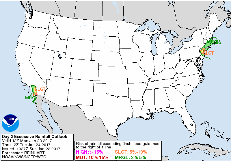
EXCESSIVE RAINFALL DISCUSSION
NWS WEATHER PREDICTION CENTER COLLEGE PARK MD
758 PM EST FRI JAN 20 2017

...VALID 01Z SAT JAN 21 2017 - 12Z SAT JAN 21 2017...
...REFERENCE AWIPS GRAPHIC UNDER...DAY 1 EXCESSIVE RAINFALL...


MARGINAL RISK OF RAINFALL EXCEEDING FFG TO THE RIGHT OF A LINE FROM
20 N NSI 10 WSW VNY 20 ESE PMD 25 NNW PSP 30 NE CZZ 60 SSE CZZ
85 S MMTJ 105 SSW NRS 90 SSW NUC.

MARGINAL RISK OF RAINFALL EXCEEDING FFG TO THE RIGHT OF A LINE FROM
20 NW KMZG IAH 15 N POE 35 SE GTR 30 NW MXF 15 ENE GZH
25 SE PQL 10 W S58.

SLIGHT RISK OF RAINFALL EXCEEDING FFG TO THE RIGHT OF A LINE FROM
25 NE NSI 10 NNE EMT 15 NE RIV 20 SSW PSP 15 N CZZ 25 SSW CZZ
35 SSW NRS 60 WSW NZY.

SLIGHT RISK OF RAINFALL EXCEEDING FFG TO THE RIGHT OF A LINE FROM
15 N KBQX 10 ESE IAH 10 NW HEZ 25 E NMM 45 NNW GZH 30 NNE BFM
25 SSW HSA 25 W KEIR.


0100 UTC UPDATE...

TWO NOTABLE CHANGES WERE MADE TO THE PREVIOUS DAY 1 EXCESSIVE
RAINFALL OUTLOOK. FIRST...WAS ABLE TO TRIM THE NORTHERN TWO-THIRDS
OF THE MARGINAL AND SLIGHT RISK AREAS ACROSS CA...BASED ON THE
LATEST RADAR AND SATELLITE TRENDS...ALONG WITH THE FORECAST GOING
FORWARD AS THE NARROWING ATMOSPHERIC RIVER CONTINUES TO WEAKEN AS
IT AND THE COLD FRONT IN ITS WAKE PUSH SOUTH OF THE STATE LATER
THIS EVENING.

ELSEWHERE...HAVE EXPANDED THE MARGINAL AND SLIGHT RISK AREAS
FARTHER WEST THROUGH WESTERN LA AND THE UPPER TX COAST...AGAIN
ALSO BASED ON THE OBSERVATIONAL TRENDS ALONG WITH THE LATEST HRRR
TRENDS.

HURLEY

...CALIFORNIA...

BROAD SCALE CYCLONIC FLOW EXISTS OVER THE WESTERN U.S...ANCHORED
UPSTREAM BY A POWERFUL 160-170 KNOT JET STREAK. A BETTER DEFINED /
DEEPER TROUGH WILL DEVELOP AND MIGRATE INTO CALIFORNIA EARLY TODAY
ALONG THE CYCLONIC SHEAR SIDE OF THIS RATHER STRAIGHT AND RATHER
STRONG JET STREAK. THIS WAVE WILL TAP INTO SUB-TROPICAL MOISTURE
AND PRODUCE DEEP ONSHORE FLOW THROUGH THE COLUMN...WITH 700 MB
U-WIND COMPONENT ANOMALIES OF 3 TO 5 STANDARD DEVIATIONS FROM
CLIMATOLOGY ALONG THE COAST. THIS ALONG WITH STRONG HEIGHT FALLS
AS THE FLOW AMPLIFIES A BIT...WILL PROMOTE SOME HEAVY RAINFALL FOR
COASTAL CALIFORNIA...PROGRESSING NORTH TO SOUTH DURING THE DAY.
RAINFALL RATES WILL LIKELY EXCEED A HALF INCH PER HOUR AT
TIMES...LEADING TO EVENT TOTALS OF 2.0 TO 3.5 INCHES IN THE
FAVORED TERRAIN ALONG THE COAST...AS WELL AS SIMILAR LIQUID
EQUIVALENTS OVER THE SOUTHERN END OF THE SIERRAS. ALONG THE COAST
THE RAINFALL WILL BE FAIRLY EVENLY DISTRIBUTED FROM MONTEREY TO
SAN DIEGO...AS THE SYSTEM WILL REMAIN POTENT BUT PROGRESSIVE.
FLOODING / FLASH FLOODING WILL BE POSSIBLE.


...CENTRAL GULF COAST STATES...

THE NEXT IN A SERIES OF ENERGETIC AND PROGRESSIVE SHORTWAVE
TROUGHS WILL PULL OUT IN THE PLAINS TODAY...ACTING TO TIGHTEN
GRADIENTS AND STRENGTHEN A JET STREAK WITHIN SSW - NNE FLOW OVER
THE WESTERN GULF STATES. THE LOW LEVEL
RESPONSE WILL DRAW MOISTURE AND INSTABILITY RAPIDLY BACK NORTHWARD
OUT OF THE GULF INTO LOUISIANA AND ADJACENT PARTS OF TX / MS. THE
GREATEST MOISTURE FLUX SHOULD BE ORIENTED INTO SOUTHERN LOUISIANA
BY 00-06Z
THE 21ST...WITH WINDS THEN BEGINNING TO VEER AS THE SYNOPTIC FLOW
REGIME REMAINS PROGRESSIVE. THEREFORE...WE FAVORED SOLUTIONS SUCH
AS THE NSSL WRF AND GEM REGIONAL WHICH DEPICT HEAVIER SWATHS OF
RAIN ORIGINATING IN SOUTHERN LOUISIANA AND EXPANDING EASTWARD.
THIS ORIENTATION...AS DEPICTED IN THE DETERMINISTIC WPC
FORECAST...WOULD OVERLAP WITH AREAS THAT SAW HEAVY RAIN ON
THURSDAY...AND WHERE FLASH FLOOD GUIDANCE VALUES HAVE DECREASED.
WE ENCOMPASSED MUCH OF SOUTHERN LOUISIANA AND SOUTHERN MISSISSIPPI
IN A SLIGHT RISK OF EXCESSIVE RAINFALL...BUT WERE ALSO GENEROUS
WITH THE NORTHERN EXPANSE OF THE SLIGHT AND MARGINAL RISK
AREAS...ACCOUNTING FOR UNCERTAINTY AND ACCOUNTING FOR A SECONDARY
SWATH OF HEAVIER RAIN RATES SEEN IN MUCH OF THE HI-RES GUIDANCE
OVER NORTHERN LA / CENTRAL MS. THIS SEEMS TO CORRESPOND TO MID
LEVEL FRONTOGENESIS AND DEEP LAYER Q-VECTOR CONVERGENCE PER THE
GFS AND ECMWF.

BURKE
Winter Weather Forecasts Legacy Page:


» Interactive Winter Weather Map (Day 1-3)
» Interactive Winter Weather Map (Day 4-7)
+ Forecast Discussion (Day 1-3)
+ Additional Links
» Interactive Winter Weather Map (Day 4-7)
+ Forecast Discussion (Day 1-3)
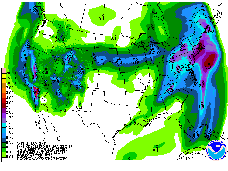
PROBABILISTIC HEAVY SNOW AND ICING DISCUSSION
NWS WEATHER PREDICTION CENTER COLLEGE PARK MD
453 PM EST FRI JAN 20 2017

VALID 00Z SAT JAN 21 2017 - 00Z TUE JAN 24 2017

DAYS 1-3...

...WESTERN U.S....

AN ACTIVE PATTERN IS EXPECTED TO CONTINUE FOR THE WESTERN
U.S....PARTICULARLY FOR CALIFORNIA OVER THE NEXT 3 DAYS...WITH
HEAVY MOUNTAIN SNOWS AND THE POTENTIAL FOR ADDITIONAL
ACCUMULATIONS EXCEEDING 4 FEET ALONG THE HIGHER PEAKS IN THE
SIERRA.

FOR FRI EVENING EVENING THROUGH THE OVERNIGHT HOURS INTO SAT...A
WELL-DEFINED MID-LEVEL SHORTWAVE/STRONG UPPER JET IS EXPECTED TO
DIG SOUTH OF THE UPPER LOW THAT IS CURRENTLY CENTERED OFF OF THE
PACIFIC NORTHWEST COAST.  ANOMALOUS MOISTURE ADVECTION AFFORDED BY
STRONG SOUTHWESTERLY FLOW AHEAD OF THE ASSOCIATED COLD FRONT
INTERACTING WITH FAVORABLE UPPER JET DYNAMICS WILL HELP SUPPORT
HEAVY SNOWS INTO THE EVENING HOURS ALONG THE SOUTHERN CA COASTAL
RANGES THAT WILL TRANSLATE EAST INTO THE INTERIOR SOUTHWESTERN
U.S. OVERNIGHT...IMPACTING THE MOUNTAINS OF SOUTHERN UT AND
ARIZONA RIM COUNTRY BEFORE REACHING INTO PORTIONS OF NEW MEXICO
AND SOUTHERN CO BY EARLY SAT.  MEANWHILE...PERSISTENT ONSHORE FLOW
WILL CONTINUE TO SUPPORT ADDITIONAL HEAVY SNOWS ALONG THE COASTAL
RANGES OF NORTHWESTERN CA AND SIERRA BEFORE A SHORTWAVE RIDGE
OFFERS A BRIEF RESPITE LATE SAT.

HEAVY PRECIPITATION IS EXPECTED TO RETURN TO NORTHERN CA ON SUN AS
A NEW LOW FORMS OFF OF THE PACIFIC NORTHWEST COAST WITH A STRONG
UPPER JET TO ITS SOUTH EXTENDING INTO NORTHERN CA.  THIS WILL
SUPPORT A FRESH ROUND OF HEAVY SNOWS FOR THE NORTHERN COASTAL
RANGES OF CA INTO THE SOUTHERN CASCADES AND THE SIERRA.  FROM LATE
SUN INTO MON...THE AFOREMENTIONED RIDGE WILL CONTINUE TO GIVE WAY
TO AN AMPLIFYING TROUGH...WITH AN AXIS OF DEEP ONSHORE FLOW
SHIFTING SOUTH ACROSS CA.  AS HEAVY SNOWS CONTINUE ALONG THE
SIERRA...RESIDUAL MOISTURE SPREADING EAST WILL SUPPORT THE
DEVELOPMENT OF LOCALLY HEAVY SNOWS ACROSS OROGRAPHICALLY FAVORED
REGIONS ACROSS THE CENTRAL GREAT BASIN AND PORTIONS OF THE
ROCKIES...INCLUDING THE TETONS...UINTAS...WASATCH AND THE WESTERN
CO RANGES.  AS THE TROUGH CONTINUES TO AMPLIFY...LOCALLY HEAVY
SNOWS ARE EXPECTED TO RETURN TO THE COASTAL RANGES OF SOUTHERN CA
EARLY MON.

DAY 3...

INTERIOR NORTHEAST...

GUIDANCE SHOWS THE SHORTWAVE TROUGH IMPACTING THE SOUTHWESTERN
U.S. FRI EVENING INTO SAT...SHIFTING EAST OF THE SOUTHERN ROCKIES
WITH A CLOSED LOW DEVELOPING OVER THE SOUTHERN HIGH PLAINS SAT
EVENING.  THIS LOW IS EXPECTED TO SPIN ACROSS THE SOUTHERN PLAINS
AND LOWER MS VALLEY ON SUN BEFORE BEGINNING TO LIFT TO THE NORTH
AS IT MOVES ACROSS THE SOUTHEASTERN U.S. EARLY MON.  GUIDANCE
BEGINS TO DIVERGE ON MON WITH RESPECT TO THE TRACK AND AMPLITUDE
OF THE LOW...CONTRIBUTING TO SIGNIFICANT PRECIPITATION TYPE
DIFFERENCES ACROSS THE INTERIOR NORTHEAST SUN NIGHT-EARLY MON.  TO
VARYING DEGREES GUIDANCE SHOWS COOLER AIR ASSOCIATED WITH A
BLOCKING HIGH OVER SOUTHEASTERN CANADA SPILLING SOUTH...OFFERING A
PERIOD OF MIXED PRECIPITATION WITH ACCUMULATING SNOWS ALONG THE
NORTHERN PERIPHERY OF THE PRECIPITATION SHIELD AS IT REACHES INTO
NORTHERN PA...UPSTATE NY AND CENTRAL TO NORTHERN NEW ENGLAND MON
MORNING.  GIVEN THE UNCERTAINTY...THE WPC FORECAST FAVORED AMOUNTS
THAT WERE HEAVIER THAN THE WARMER GFS...BUT ALSO DOWNPLAYED THE
FORECAST FOR HEAVIER AMOUNTS PRESENTED BY THE NAM...THE 09Z
SREFMEAN AND THE 00Z ECMWF.

PEREIRA
Medium Range Forecasts Legacy Page:
Valid 12Z Tue Jan 24, 2017
Valid 12Z Wed Jan 25, 2017
Valid 12Z Thu Jan 26, 2017
Valid 12Z Fri Jan 27, 2017
Valid 12Z Sat Jan 28, 2017
Image Options:


+ Forecast Discussion
+ Additional Links
EXTENDED FORECAST DISCUSSION
NWS WEATHER PREDICTION CENTER COLLEGE PARK MD
836 AM EST FRI JAN 20 2017
VALID 12Z MON JAN 23 2017 - 12Z FRI JAN 27 2017
...SNOW POTENTIAL FOR THE INTERIOR NORTHEAST AND CENTRAL/HIGH
PLAINS TO THE UPPER MIDWEST NEXT WEEK...
SYNOPTIC PATTERN & MODEL PREFERENCES
~~~~~~~~~~~~~~~~~~~~~~~~~~~~~~~~~~~~
RETROGRADING RIDGING ACROSS CANADA FORCED BY A TROUGH SHARPENING
ALONG 160W LONGITUDE SHOULD REORIENT THE TROUGH, STRETCHING FROM
EASTERN CANADA THROUGH THE CENTRAL/SOUTHERN PLAINS TOWARDS THE SEA
OF CORTEZ/GULF OF CALIFORNIA. THE GUIDANCE REMAINS IN BETTER THAN
AVERAGE AGREEMENT. FOR THE PRESSURES, 500 HPA HEIGHTS, AND WIND
GRIDS, A COMPROMISE OF THE 00Z CANADIAN/00Z ECMWF/00Z UKMET/06Z
GFS WAS UTILIZED EARLY BEFORE USING INCREASING AMOUNTS OF THE 00Z
ECMWF ENSEMBLE MEAN AND 00Z NAEFS MEAN MID TO LATE NEXT WEEK.
OTHER WEATHER GRIDS WILL BE MORE HEAVILY ENSEMBLE MEAN BASED TO
REFLECT FORECAST UNCERTAINTY. THE DAYS 4-7 QPF WILL START OUT AS
A COMPROMISE OF THE 06Z GFS/00Z ECMWF, WITH SOME 12Z GFS THROWN IN
MIDDAY IF ITS MASS FIELDS LOOK REASONABLE.
WEATHER HIGHLIGHTS/THREATS
~~~~~~~~~~~~~~~~~~~~~~~~~~
THE LEAD SYSTEM IN THE EAST/NORTHEAST WILL LIKELY TRANSPORT
SIGNIFICANT MOISTURE FROM THE TROPICS/SUBTROPICS NORTH THEN
NORTHWEST INTO MILD AIR FOR THIS TIME OF THE YEAR FOR AN ARRAY OF
WINTRY PRECIPITATION TYPES. INGREDIENTS ARE THERE FOR AN INTERIOR
EVENT THANKS TO WARMER TEMPERATURES ALOFT IMPORTED BY THIS SYSTEM
AND A CANADIAN HIGH PRESSURE TO THE NORTH KEEPING COOLER AIR AT
THE SURFACE. AN UPSTREAM KICKER WILL ENSURE THIS ONE WILL NOT
LINGER BUT PRECIPITATION RATES COULD BE IMPRESSIVE.
SIGNIFICANT PRECIPITATION SHOULD DIMINISH IN THE WEST AND INTERIOR
WEST BY MIDWEEK AS THE UPPER TROUGH SWINGS INTO THE PLAINS.
WIDESPREAD MOUNTAIN SNOWS FROM THE SIERRAS TO THE WASATCH AND THE
MOGOLLON RIM TO THE COLORADO ROCKIES SHOULD WIND DOWN TUESDAY INTO
WEDNESDAY AS THE SURFACE LOW ORGANIZES OVER KANSAS AND LIFTS
NORTHEASTWARD. SNOW WILL EXPAND TO THE NORTHEAST ON THE NORTH SIDE
OF THE LOW WHERE SIGNIFICANT ACCUMULATIONS ARE POSSIBLE. AXIS OF
HEAVIEST QPF SHOULD BE NEAR THE NE/SD BORDER INTO SOUTHERN WI.
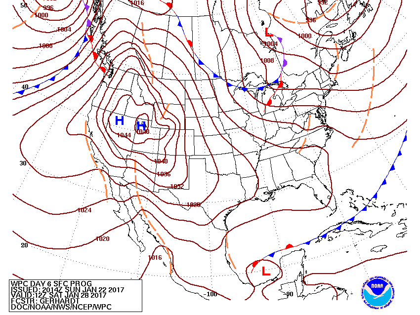
BY LATER IN THE WEEK, PATTERN BECOMES QUIET AS THE FRONT SETTLES
INTO FLORIDA AND HIGH PRESSURE IS IN FIRM CONTROL OF THE WEST,
SEIZING INCREASING TERRITORY TO THE EAST WITH TIME. DESPITE THE
HIGHER 500 HPA HEIGHTS, NORTHERLY UPPER FLOW AND 700MB TEMPS ABOUT
1-2 SIGMAS BELOW AVERAGE WILL KEEP TEMPERATURES DOWN. MILD
TEMPERATURES IN THE EAST SHOULD TREND BACK TOWARD CLIMATOLOGY AS
TROUGHING INCREASES ACROSS THE AREA. LAKE EFFECT SNOW PRODUCTION
WILL PICK UP THURSDAY/FRIDAY WITH NORTH/NORTH-NORTHWEST FLOW.
ROTH/FRACASSO
Forecast Tools (Prototype):
1/3/6/24-hr Changes

Change in weather parameters over the last 1/3/6/24 hours. The data used here is either from the Real-Time Mesoscale Analysis (RTMA) or the Rapid Refresh (RAP). The RTMA is shown at its native resolution of 2.5km and is used for surface variables. The RAP is shown at 32km (native resolution 13km) and is primarily used for non-surface (i.e., upper level) variables. For more information please see the RTMA or the RAP website.
GEFS Probabilities

This forecast product shows probabilistic information for the lower 48 states from the GEFS. This updates four times daily. Probabilities of exceeding or remaining less than such variables as precipitation, temperature, or sea-level pressure at various thresholds are displayed.
Links to Other Useful Forecast Tools
Meteorological Conversions and CalculationsStorm Prediction Center's Forecast Tools
Ensemble Situational Awareness Table


.jpg)