
Find the latest maps by property address or by community.
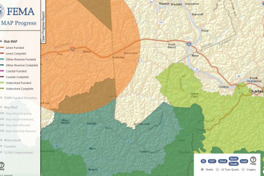
Risk MAP projects have been funded across the Nation. Visit and learn about projects in your area today.

Communities are using Risk MAP products and tools to help reduce and communicate about flood risk.

Get a visual overview of what FEMA flood maps are and how the map update process works using the Flood Map Infographic.
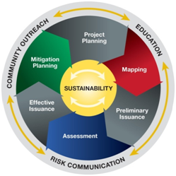
This page discusses the Risk MAP project lifecycle for flood risk projects. This page is intended for a variety of audiences, including state and community officials; homeowners, renters and business owners; real estate, lending, insurance professionals; engineers, surveyors and architects.
In the Risk Mapping, Assessment and Planning (Risk MAP) program, each flood risk project is tailored to the needs and capabilities of each affected community and may involve different steps, products and services. This page outlines the major steps in a typical flood risk project. For all projects, a strong emphasis is placed on community engagement and partnerships to ensure a whole community approach to reducing flood risk and building more resilient and sustainable communities.
 Take Action!
To understand your flood risk and view your flood maps, visit the Flood Map Service Center (MSC).
To learn more about the National Flood Insurance Program (NFIP) and how to get flood insurance, visit www.Floodsmart.gov.
Take action to Plan & Prepare for yourself, your family, and your community.
Project Planning
Selecting the Project area
First, with input from state and local leaders, a watershed is reviewed to determine if there may be a need for new or updated Flood Insurance Rate Maps (FIRMs) or other flood risk products. This decision is based on the current flood risk in the area, available data, increases in development, population affected and other related factors.
Visit the CNMS webpage and fact sheet for more information on how CNMS aids in this process.
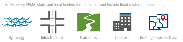
The Discovery Process
Next, FEMA, state and local leaders collect current and historic flood-related data and then meet to review this data, as part of the Discovery process to get a complete picture of the area’s flood risk. This information helps determine whether a flood risk project is actually needed and, if so, what the scope of the project will be.
View Success stories about Project planning
Mapping and Data
Data and Product Development
Once a flood risk project is initiated, FEMA and its mapping partners move forward with preparing the data, maps and flood risk products. These may include the regulatory Flood Insurance Rate Map (FIRM) and Flood Insurance Study (FIS) report used for floodplain management and insurance requirements and non-regulatory flood risk products which can be used by local officials to support mitigation and community planning and public outreach efforts.
FEMA maintains guidelines and standards to support the Risk MAP program, including defining requirements for flood risk analysis and mapping products, Letters of Map Change and other Risk MAP data and product development activities.
The Flood Risk Review Meeting
An optional Flood Risk Review Meeting may be organized to give community officials the chance to review and provide early feedback on draft versions of the preliminary FIRM and FIS report and flood risk products. Using the information provided, community officials can begin identifying mitigation measures for their community and communicating with the public about possible changes in flood risk.
The Resilience Meeting
As communities are reviewing the Risk MAP products delivered, the Resilience Meeting takes place, before or after the release of preliminary FIRMs, to help communities plan for the future. During this meeting, FEMA, state and local leaders discuss factors contributing to flooding in the project area, ways the Risk MAP products can support ongoing risk assessment and planning efforts and work to identify additional ways to reduce flood risk.
View Success stories about mapping and data
Preliminary FIRM Issuance
Distribution of Maps and Data
Preliminary versions of the FIRM and FIS report are delivered to community officials and posted publicly through FEMA’s Flood Map Service Center for review and comment. These products will show new or updated 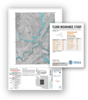 flood hazard data which will affect floodplain development requirements and/or flood insurance rates in communities once effective.
The CCO Meeting and Public Open House
After the release of preliminary FIRMs and FIS reports, FEMA holds meetings to present them first to community officials (Consultation Coordination Officer or CCO Meeting) and then the general public (Open House). Any changes in flood risk will be explained and participants will have an opportunity to provide feedback on the products.
The 90-Day Appeal Period
After the CCO Meeting, a 90-day appeal period for communities with new or updated flood hazards begins after a public notification process is completed. During this period, communities or the public (through their community officials) can submit data to revise the FIRM if they believe it is scientifically or technically incorrect. FEMA will review all appeals and, if necessary, make changes to the FIRM, based on the information submitted.
View Success stories about preliminary firm issuance
Risk Assessment
Flood Risk Products
Risk MAP provides local officials with flood risk products, including risk assessments using FEMA’s Hazus-MH software, to help them better understand their flood risk, its potential impact and to guide local mitigation and outreach efforts. These products are usually presented during the Flood Risk Review, CCO and/or Resilience Meetings and are available publicly through FEMA’s Flood Map Service Center.
View Success stories about flood risk products
Effective FIRM and FIS Report Issuance
After all appeals are resolved, FEMA sends community officials a Letter of Final Determination (LFD) six months before the new FIRM and FIS report become effective. During this six-month period, communities must adopt or amend their floodplain management ordinance to reflect the new maps. Once the new FIRM takes effect, it will be available through FEMA’s Flood Map Service Center and will affect floodplain development requirements and/or flood insurance rates.
View Success stories about effective firm and fis report issuance
Planning for Mitigation Action
The flood risk products developed as part of a flood risk project are designed to help communities effectively plan to mitigate flood risk. Flood Risk Review, Resilience and CCO Meetings allow FEMA and its partners to provide guidance to local officials to help them identify mitigation opportunities that work for their community. Mitigation efforts influenced by Risk MAP are tracked using the Risk MAP Mitigation Action Tracker.